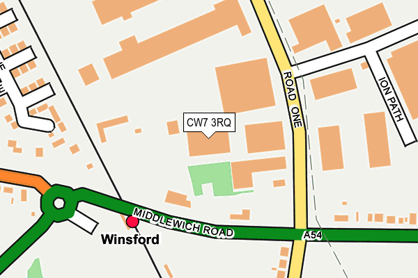
CW7 3RQ is located in the Winsford Gravel electoral ward, within the unitary authority of Cheshire West and Chester and the English Parliamentary constituency of Eddisbury. The Sub Integrated Care Board (ICB) Location is NHS Cheshire and Merseyside ICB - 27D and the police force is Cheshire. This postcode has been in use since October 2003.


GetTheData
Source: OS OpenMap – Local (Ordnance Survey)
Source: OS VectorMap District (Ordnance Survey)
Licence: Open Government Licence (requires attribution)
| Easting | 367347 |
| Northing | 366178 |
| Latitude | 53.191694 |
| Longitude | -2.490166 |
GetTheData
Source: Open Postcode Geo
Licence: Open Government Licence
| Country | England |
| Postcode District | CW7 |
➜ See where CW7 is on a map ➜ Where is Winsford? | |
GetTheData
Source: Land Registry Price Paid Data
Licence: Open Government Licence
Elevation or altitude of CW7 3RQ as distance above sea level:
| Metres | Feet | |
|---|---|---|
| Elevation | 40m | 131ft |
Elevation is measured from the approximate centre of the postcode, to the nearest point on an OS contour line from OS Terrain 50, which has contour spacing of ten vertical metres.
➜ How high above sea level am I? Find the elevation of your current position using your device's GPS.
GetTheData
Source: Open Postcode Elevation
Licence: Open Government Licence
| Ward | Winsford Gravel |
| Constituency | Eddisbury |
GetTheData
Source: ONS Postcode Database
Licence: Open Government Licence
| Road Three (Road One) | Winsford Industrial Estate | 56m |
| Road Three (Road One) | Winsford Industrial Estate | 60m |
| Road One (Middlewich Road) | Clive | 143m |
| Kwik Save (Road Three) | Winsford Industrial Estate | 148m |
| Road One (Middlewich Road) | Clive | 158m |
| Winsford Station | 0.3km |
GetTheData
Source: NaPTAN
Licence: Open Government Licence
GetTheData
Source: ONS Postcode Database
Licence: Open Government Licence


➜ Get more ratings from the Food Standards Agency
GetTheData
Source: Food Standards Agency
Licence: FSA terms & conditions
| Last Collection | |||
|---|---|---|---|
| Location | Mon-Fri | Sat | Distance |
| Queens Hotel | 17:30 | 11:30 | 2,651m |
| Nantwich Road | 16:00 | 11:00 | 3,098m |
| Occleston School | 16:15 | 07:45 | 3,108m |
GetTheData
Source: Dracos
Licence: Creative Commons Attribution-ShareAlike
The below table lists the International Territorial Level (ITL) codes (formerly Nomenclature of Territorial Units for Statistics (NUTS) codes) and Local Administrative Units (LAU) codes for CW7 3RQ:
| ITL 1 Code | Name |
|---|---|
| TLD | North West (England) |
| ITL 2 Code | Name |
| TLD6 | Cheshire |
| ITL 3 Code | Name |
| TLD63 | Cheshire West and Chester |
| LAU 1 Code | Name |
| E06000050 | Cheshire West and Chester |
GetTheData
Source: ONS Postcode Directory
Licence: Open Government Licence
The below table lists the Census Output Area (OA), Lower Layer Super Output Area (LSOA), and Middle Layer Super Output Area (MSOA) for CW7 3RQ:
| Code | Name | |
|---|---|---|
| OA | E00094572 | |
| LSOA | E01018733 | Cheshire West and Chester 035A |
| MSOA | E02003886 | Cheshire West and Chester 035 |
GetTheData
Source: ONS Postcode Directory
Licence: Open Government Licence
| CW7 3NQ | Middlewich Road | 184m |
| CW7 3NH | Middlewich Road | 216m |
| CW7 3NU | Clive Lane | 242m |
| CW7 3NJ | Moss Lane | 257m |
| CW7 3PZ | Road One | 261m |
| CW7 3NT | Middlewich Road | 309m |
| CW7 3PB | Rilshaw Lane | 318m |
| CW7 3TT | Nunsmere Close | 417m |
| CW7 3LG | Thames Place | 445m |
| CW7 3LH | Mersey Place | 470m |
GetTheData
Source: Open Postcode Geo; Land Registry Price Paid Data
Licence: Open Government Licence