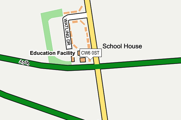
CW6 0ST is located in the Tarvin & Kelsall electoral ward, within the unitary authority of Cheshire West and Chester and the English Parliamentary constituency of Eddisbury. The Sub Integrated Care Board (ICB) Location is NHS Cheshire and Merseyside ICB - 27D and the police force is Cheshire. This postcode has been in use since January 1980.


GetTheData
Source: OS OpenMap – Local (Ordnance Survey)
Source: OS VectorMap District (Ordnance Survey)
Licence: Open Government Licence (requires attribution)
| Easting | 355284 |
| Northing | 368433 |
| Latitude | 53.211082 |
| Longitude | -2.671015 |
GetTheData
Source: Open Postcode Geo
Licence: Open Government Licence
| Country | England |
| Postcode District | CW6 |
➜ See where CW6 is on a map | |
GetTheData
Source: Land Registry Price Paid Data
Licence: Open Government Licence
Elevation or altitude of CW6 0ST as distance above sea level:
| Metres | Feet | |
|---|---|---|
| Elevation | 100m | 328ft |
Elevation is measured from the approximate centre of the postcode, to the nearest point on an OS contour line from OS Terrain 50, which has contour spacing of ten vertical metres.
➜ How high above sea level am I? Find the elevation of your current position using your device's GPS.
GetTheData
Source: Open Postcode Elevation
Licence: Open Government Licence
| Ward | Tarvin & Kelsall |
| Constituency | Eddisbury |
GetTheData
Source: ONS Postcode Database
Licence: Open Government Licence
| Primary School (Chester Road) | Delamere | 40m |
| Primary School (Chester Road) | Delamere | 48m |
| St Peter's Church (Chester Road) | Delamere | 684m |
| Post Office (Station Road) | Delamere | 1,027m |
| Old Toll House (Chester Road) | Delamere | 1,100m |
| Delamere Station | 2km |
| Mouldsworth Station | 4.7km |
| Cuddington Station | 5.8km |
GetTheData
Source: NaPTAN
Licence: Open Government Licence
GetTheData
Source: ONS Postcode Database
Licence: Open Government Licence


➜ Get more ratings from the Food Standards Agency
GetTheData
Source: Food Standards Agency
Licence: FSA terms & conditions
| Last Collection | |||
|---|---|---|---|
| Location | Mon-Fri | Sat | Distance |
| Cheese Hill | 16:15 | 10:45 | 4,095m |
| Delamere Park | 16:45 | 08:00 | 4,952m |
| Portal | 16:00 | 09:30 | 5,041m |
GetTheData
Source: Dracos
Licence: Creative Commons Attribution-ShareAlike
The below table lists the International Territorial Level (ITL) codes (formerly Nomenclature of Territorial Units for Statistics (NUTS) codes) and Local Administrative Units (LAU) codes for CW6 0ST:
| ITL 1 Code | Name |
|---|---|
| TLD | North West (England) |
| ITL 2 Code | Name |
| TLD6 | Cheshire |
| ITL 3 Code | Name |
| TLD63 | Cheshire West and Chester |
| LAU 1 Code | Name |
| E06000050 | Cheshire West and Chester |
GetTheData
Source: ONS Postcode Directory
Licence: Open Government Licence
The below table lists the Census Output Area (OA), Lower Layer Super Output Area (LSOA), and Middle Layer Super Output Area (MSOA) for CW6 0ST:
| Code | Name | |
|---|---|---|
| OA | E00094422 | |
| LSOA | E01018707 | Cheshire West and Chester 045A |
| MSOA | E02003891 | Cheshire West and Chester 045 |
GetTheData
Source: ONS Postcode Directory
Licence: Open Government Licence
| CW6 0SU | Watling Drive | 139m |
| CW8 2HS | Chester Road | 543m |
| CW6 0SS | 579m | |
| CW6 0SR | Organsdale | 601m |
| CW6 0SX | Stoney Lane | 667m |
| CW8 2HX | The Ridge | 914m |
| CW6 0GL | Old Pale Heights | 949m |
| CW8 2HU | Station Road | 1003m |
| CW6 0JS | Heaths Lane | 1030m |
| CW8 2HY | Eddisbury Hill | 1042m |
GetTheData
Source: Open Postcode Geo; Land Registry Price Paid Data
Licence: Open Government Licence