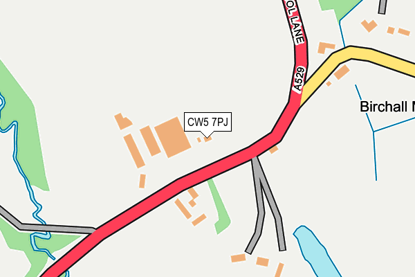
CW5 7PJ lies on Audlem Road in Hatherton, Nantwich. CW5 7PJ is located in the Wybunbury electoral ward, within the unitary authority of Cheshire East and the English Parliamentary constituency of Crewe and Nantwich. The Sub Integrated Care Board (ICB) Location is NHS Cheshire and Merseyside ICB - 27D and the police force is Cheshire. This postcode has been in use since March 1982.


GetTheData
Source: OS OpenMap – Local (Ordnance Survey)
Source: OS VectorMap District (Ordnance Survey)
Licence: Open Government Licence (requires attribution)
| Easting | 367831 |
| Northing | 346089 |
| Latitude | 53.011150 |
| Longitude | -2.480905 |
GetTheData
Source: Open Postcode Geo
Licence: Open Government Licence
| Street | Audlem Road |
| Locality | Hatherton |
| Town/City | Nantwich |
| Country | England |
| Postcode District | CW5 |
➜ See where CW5 is on a map ➜ Where is Birchall Moss? | |
GetTheData
Source: Land Registry Price Paid Data
Licence: Open Government Licence
Elevation or altitude of CW5 7PJ as distance above sea level:
| Metres | Feet | |
|---|---|---|
| Elevation | 60m | 197ft |
Elevation is measured from the approximate centre of the postcode, to the nearest point on an OS contour line from OS Terrain 50, which has contour spacing of ten vertical metres.
➜ How high above sea level am I? Find the elevation of your current position using your device's GPS.
GetTheData
Source: Open Postcode Elevation
Licence: Open Government Licence
| Ward | Wybunbury |
| Constituency | Crewe And Nantwich |
GetTheData
Source: ONS Postcode Database
Licence: Open Government Licence
| Birchall Moss Lane (Bridgemere Lane) | Birchall Moss | 552m |
| White Lion Ph (Audlem Road) | Hankelow | 955m |
| White Lion Ph (Audlem Road) | Hankelow | 974m |
| Oakes Corner (Audlem Road) | Hatherton | 1,174m |
| Oakes Corner (Audlem Road) | Hatherton | 1,178m |
GetTheData
Source: NaPTAN
Licence: Open Government Licence
| Percentage of properties with Next Generation Access | 100.0% |
| Percentage of properties with Superfast Broadband | 100.0% |
| Percentage of properties with Ultrafast Broadband | 88.9% |
| Percentage of properties with Full Fibre Broadband | 88.9% |
Superfast Broadband is between 30Mbps and 300Mbps
Ultrafast Broadband is > 300Mbps
| Percentage of properties unable to receive 2Mbps | 0.0% |
| Percentage of properties unable to receive 5Mbps | 0.0% |
| Percentage of properties unable to receive 10Mbps | 0.0% |
| Percentage of properties unable to receive 30Mbps | 0.0% |
GetTheData
Source: Ofcom
Licence: Ofcom Terms of Use (requires attribution)
GetTheData
Source: ONS Postcode Database
Licence: Open Government Licence


➜ Get more ratings from the Food Standards Agency
GetTheData
Source: Food Standards Agency
Licence: FSA terms & conditions
| Last Collection | |||
|---|---|---|---|
| Location | Mon-Fri | Sat | Distance |
| Hatherton So | 16:00 | 08:30 | 470m |
| Hankelow | 16:00 | 12:00 | 1,046m |
| Hunsterson | 16:45 | 08:30 | 1,906m |
GetTheData
Source: Dracos
Licence: Creative Commons Attribution-ShareAlike
The below table lists the International Territorial Level (ITL) codes (formerly Nomenclature of Territorial Units for Statistics (NUTS) codes) and Local Administrative Units (LAU) codes for CW5 7PJ:
| ITL 1 Code | Name |
|---|---|
| TLD | North West (England) |
| ITL 2 Code | Name |
| TLD6 | Cheshire |
| ITL 3 Code | Name |
| TLD62 | Cheshire East |
| LAU 1 Code | Name |
| E06000049 | Cheshire East |
GetTheData
Source: ONS Postcode Directory
Licence: Open Government Licence
The below table lists the Census Output Area (OA), Lower Layer Super Output Area (LSOA), and Middle Layer Super Output Area (MSOA) for CW5 7PJ:
| Code | Name | |
|---|---|---|
| OA | E00093429 | |
| LSOA | E01018515 | Cheshire East 049C |
| MSOA | E02003837 | Cheshire East 049 |
GetTheData
Source: ONS Postcode Directory
Licence: Open Government Licence
| CW5 7PL | Bridgemere Lane | 468m |
| CW3 0JH | Park View | 601m |
| CW5 7PH | Broomlands Cottages | 619m |
| CW3 0JF | Swedish Houses | 648m |
| CW3 0JE | Audlem Road | 680m |
| CW3 0JW | The Nook | 802m |
| CW3 0JN | Old School Lane | 963m |
| CW3 0JG | Longhill Lane | 970m |
| CW3 0JB | Hall Lane | 1013m |
| CW3 0JL | Monks Lane | 1072m |
GetTheData
Source: Open Postcode Geo; Land Registry Price Paid Data
Licence: Open Government Licence