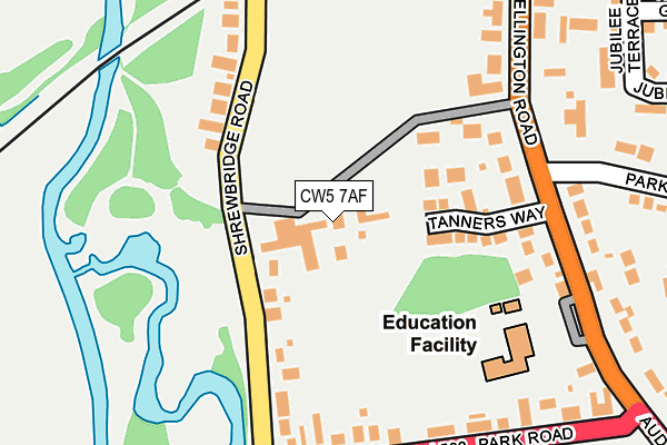
CW5 7AF lies on Brookfield Park in Nantwich. CW5 7AF is located in the Nantwich South and Stapeley electoral ward, within the unitary authority of Cheshire East and the English Parliamentary constituency of Crewe and Nantwich. The Sub Integrated Care Board (ICB) Location is NHS Cheshire and Merseyside ICB - 27D and the police force is Cheshire. This postcode has been in use since July 1986.


GetTheData
Source: OS OpenMap – Local (Ordnance Survey)
Source: OS VectorMap District (Ordnance Survey)
Licence: Open Government Licence (requires attribution)
| Easting | 365072 |
| Northing | 351583 |
| Latitude | 53.060362 |
| Longitude | -2.522621 |
GetTheData
Source: Open Postcode Geo
Licence: Open Government Licence
| Street | Brookfield Park |
| Town/City | Nantwich |
| Country | England |
| Postcode District | CW5 |
➜ See where CW5 is on a map ➜ Where is Nantwich? | |
GetTheData
Source: Land Registry Price Paid Data
Licence: Open Government Licence
Elevation or altitude of CW5 7AF as distance above sea level:
| Metres | Feet | |
|---|---|---|
| Elevation | 40m | 131ft |
Elevation is measured from the approximate centre of the postcode, to the nearest point on an OS contour line from OS Terrain 50, which has contour spacing of ten vertical metres.
➜ How high above sea level am I? Find the elevation of your current position using your device's GPS.
GetTheData
Source: Open Postcode Elevation
Licence: Open Government Licence
| Ward | Nantwich South And Stapeley |
| Constituency | Crewe And Nantwich |
GetTheData
Source: ONS Postcode Database
Licence: Open Government Licence
2, BROOKFIELD PARK, NANTWICH, CW5 7AF 2009 30 NOV £220,000 |
GetTheData
Source: HM Land Registry Price Paid Data
Licence: Contains HM Land Registry data © Crown copyright and database right 2025. This data is licensed under the Open Government Licence v3.0.
| St Anne's Primary School (Wellington Road) | Nantwich | 207m |
| Newbold Way (Park Road) | Nantwich | 213m |
| St Anne's Primary School (Wellington Road) | Nantwich | 254m |
| Rookery Drive (Parkfield Drive) | Nantwich | 381m |
| Station View | Nantwich | 417m |
| Nantwich Station | 0.4km |
| Wrenbury Station | 6.7km |
GetTheData
Source: NaPTAN
Licence: Open Government Licence
| Percentage of properties with Next Generation Access | 100.0% |
| Percentage of properties with Superfast Broadband | 100.0% |
| Percentage of properties with Ultrafast Broadband | 0.0% |
| Percentage of properties with Full Fibre Broadband | 0.0% |
Superfast Broadband is between 30Mbps and 300Mbps
Ultrafast Broadband is > 300Mbps
| Percentage of properties unable to receive 2Mbps | 0.0% |
| Percentage of properties unable to receive 5Mbps | 0.0% |
| Percentage of properties unable to receive 10Mbps | 0.0% |
| Percentage of properties unable to receive 30Mbps | 0.0% |
GetTheData
Source: Ofcom
Licence: Ofcom Terms of Use (requires attribution)
GetTheData
Source: ONS Postcode Database
Licence: Open Government Licence


➜ Get more ratings from the Food Standards Agency
GetTheData
Source: Food Standards Agency
Licence: FSA terms & conditions
| Last Collection | |||
|---|---|---|---|
| Location | Mon-Fri | Sat | Distance |
| Shrewbridge Road | 17:45 | 08:30 | 110m |
| Park Road | 17:45 | 08:30 | 309m |
| Station Hotel | 17:00 | 11:15 | 453m |
GetTheData
Source: Dracos
Licence: Creative Commons Attribution-ShareAlike
The below table lists the International Territorial Level (ITL) codes (formerly Nomenclature of Territorial Units for Statistics (NUTS) codes) and Local Administrative Units (LAU) codes for CW5 7AF:
| ITL 1 Code | Name |
|---|---|
| TLD | North West (England) |
| ITL 2 Code | Name |
| TLD6 | Cheshire |
| ITL 3 Code | Name |
| TLD62 | Cheshire East |
| LAU 1 Code | Name |
| E06000049 | Cheshire East |
GetTheData
Source: ONS Postcode Directory
Licence: Open Government Licence
The below table lists the Census Output Area (OA), Lower Layer Super Output Area (LSOA), and Middle Layer Super Output Area (MSOA) for CW5 7AF:
| Code | Name | |
|---|---|---|
| OA | E00093374 | |
| LSOA | E01018504 | Cheshire East 050D |
| MSOA | E02003839 | Cheshire East 050 |
GetTheData
Source: ONS Postcode Directory
Licence: Open Government Licence
| CW5 7FL | Tanners Way | 98m |
| CW5 7AD | Shrewbridge Road | 128m |
| CW5 7AA | Shrewbridge Road | 168m |
| CW5 7AG | Park Road | 194m |
| CW5 7AQ | Park Road | 224m |
| CW5 7BX | Wellington Road | 234m |
| CW5 7DA | Wellington Road | 240m |
| CW5 7BZ | Hillfield View | 282m |
| CW5 7BF | Brook Way | 290m |
| CW5 7BH | Wellington Road | 310m |
GetTheData
Source: Open Postcode Geo; Land Registry Price Paid Data
Licence: Open Government Licence