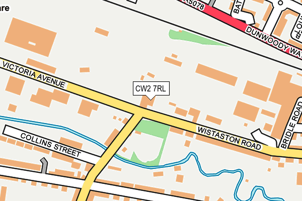
CW2 7RL is located in the Crewe West electoral ward, within the unitary authority of Cheshire East and the English Parliamentary constituency of Crewe and Nantwich. The Sub Integrated Care Board (ICB) Location is NHS Cheshire and Merseyside ICB - 27D and the police force is Cheshire. This postcode has been in use since January 1980.


GetTheData
Source: OS OpenMap – Local (Ordnance Survey)
Source: OS VectorMap District (Ordnance Survey)
Licence: Open Government Licence (requires attribution)
| Easting | 369702 |
| Northing | 355565 |
| Latitude | 53.096438 |
| Longitude | -2.453915 |
GetTheData
Source: Open Postcode Geo
Licence: Open Government Licence
| Country | England |
| Postcode District | CW2 |
➜ See where CW2 is on a map ➜ Where is Crewe? | |
GetTheData
Source: Land Registry Price Paid Data
Licence: Open Government Licence
Elevation or altitude of CW2 7RL as distance above sea level:
| Metres | Feet | |
|---|---|---|
| Elevation | 50m | 164ft |
Elevation is measured from the approximate centre of the postcode, to the nearest point on an OS contour line from OS Terrain 50, which has contour spacing of ten vertical metres.
➜ How high above sea level am I? Find the elevation of your current position using your device's GPS.
GetTheData
Source: Open Postcode Elevation
Licence: Open Government Licence
| Ward | Crewe West |
| Constituency | Crewe And Nantwich |
GetTheData
Source: ONS Postcode Database
Licence: Open Government Licence
| Stewart Street (Wistaston Road) | Crewe | 44m |
| Wisaston Road (Stewart Street) | Crewe | 88m |
| Eagle Bridge Health Centre (Dunwoody Way) | Crewe | 182m |
| Eagle Bridge Health Centre (Dunwoody Way) | Crewe | 200m |
| Stewart Street (Alton Street) | Crewe | 211m |
| Crewe Station | 1.6km |
| Nantwich Station | 5.7km |
GetTheData
Source: NaPTAN
Licence: Open Government Licence
GetTheData
Source: ONS Postcode Database
Licence: Open Government Licence


➜ Get more ratings from the Food Standards Agency
GetTheData
Source: Food Standards Agency
Licence: FSA terms & conditions
| Last Collection | |||
|---|---|---|---|
| Location | Mon-Fri | Sat | Distance |
| Wistaston Road | 17:30 | 12:30 | 264m |
| Walthall Street | 17:00 | 12:30 | 592m |
| Ford Lane | 17:30 | 12:00 | 634m |
GetTheData
Source: Dracos
Licence: Creative Commons Attribution-ShareAlike
The below table lists the International Territorial Level (ITL) codes (formerly Nomenclature of Territorial Units for Statistics (NUTS) codes) and Local Administrative Units (LAU) codes for CW2 7RL:
| ITL 1 Code | Name |
|---|---|
| TLD | North West (England) |
| ITL 2 Code | Name |
| TLD6 | Cheshire |
| ITL 3 Code | Name |
| TLD62 | Cheshire East |
| LAU 1 Code | Name |
| E06000049 | Cheshire East |
GetTheData
Source: ONS Postcode Directory
Licence: Open Government Licence
The below table lists the Census Output Area (OA), Lower Layer Super Output Area (LSOA), and Middle Layer Super Output Area (MSOA) for CW2 7RL:
| Code | Name | |
|---|---|---|
| OA | E00093339 | |
| LSOA | E01018497 | Cheshire East 039D |
| MSOA | E02003830 | Cheshire East 039 |
GetTheData
Source: ONS Postcode Directory
Licence: Open Government Licence
| CW2 7RJ | Wistaston Road | 158m |
| CW2 7PD | Valley Court | 165m |
| CW2 7RW | Stewart Street | 187m |
| CW2 7PU | Alton Street | 199m |
| CW2 7PT | Alton Street | 238m |
| CW1 3DB | Blount Close | 261m |
| CW1 3AW | Dunwoody Way | 266m |
| CW2 7RR | Collins Street | 272m |
| CW1 3DQ | Bateman Close | 284m |
| CW2 8LT | Stewart Street | 286m |
GetTheData
Source: Open Postcode Geo; Land Registry Price Paid Data
Licence: Open Government Licence