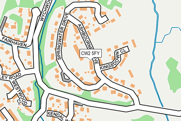
CW2 5FY lies on Ashbourne Drive in Weston, Crewe. CW2 5FY is located in the Wybunbury electoral ward, within the unitary authority of Cheshire East and the English Parliamentary constituency of Crewe and Nantwich. The Sub Integrated Care Board (ICB) Location is NHS Cheshire and Merseyside ICB - 27D and the police force is Cheshire. This postcode has been in use since July 2004.


GetTheData
Source: OS OpenMap – Local (Ordnance Survey)
Source: OS VectorMap District (Ordnance Survey)
Licence: Open Government Licence (requires attribution)
| Easting | 373123 |
| Northing | 350427 |
| Latitude | 53.050421 |
| Longitude | -2.402397 |
GetTheData
Source: Open Postcode Geo
Licence: Open Government Licence
| Street | Ashbourne Drive |
| Locality | Weston |
| Town/City | Crewe |
| Country | England |
| Postcode District | CW2 |
➜ See where CW2 is on a map ➜ Where is Weston? | |
GetTheData
Source: Land Registry Price Paid Data
Licence: Open Government Licence
Elevation or altitude of CW2 5FY as distance above sea level:
| Metres | Feet | |
|---|---|---|
| Elevation | 60m | 197ft |
Elevation is measured from the approximate centre of the postcode, to the nearest point on an OS contour line from OS Terrain 50, which has contour spacing of ten vertical metres.
➜ How high above sea level am I? Find the elevation of your current position using your device's GPS.
GetTheData
Source: Open Postcode Elevation
Licence: Open Government Licence
| Ward | Wybunbury |
| Constituency | Crewe And Nantwich |
GetTheData
Source: ONS Postcode Database
Licence: Open Government Licence
2024 13 DEC £535,000 |
2021 20 MAY £582,500 |
2021 30 APR £656,000 |
2019 27 SEP £435,000 |
2019 23 AUG £560,000 |
2018 2 MAR £430,000 |
2017 21 DEC £620,000 |
2017 6 DEC £465,000 |
2017 14 JUL £445,000 |
2016 19 AUG £570,000 |
GetTheData
Source: HM Land Registry Price Paid Data
Licence: Contains HM Land Registry data © Crown copyright and database right 2025. This data is licensed under the Open Government Licence v3.0.
| Ashbourne Drive (Wychwood Park) | Chorlton | 198m |
| St Clements Court (Waybutt Lane) | Chorlton | 366m |
| Redbourne Drive (Wychwood Park) | Chorlton | 612m |
| Little Lakes (Wychwood Park) | Weston | 722m |
| Wychwood Park (Newcastle Road) | Weston | 938m |
| Crewe Station | 4.8km |
GetTheData
Source: NaPTAN
Licence: Open Government Licence
| Percentage of properties with Next Generation Access | 100.0% |
| Percentage of properties with Superfast Broadband | 100.0% |
| Percentage of properties with Ultrafast Broadband | 100.0% |
| Percentage of properties with Full Fibre Broadband | 100.0% |
Superfast Broadband is between 30Mbps and 300Mbps
Ultrafast Broadband is > 300Mbps
| Median download speed | 3.0Mbps |
| Average download speed | 5.4Mbps |
| Maximum download speed | 39.72Mbps |
| Median upload speed | 0.4Mbps |
| Average upload speed | 1.2Mbps |
| Maximum upload speed | 10.00Mbps |
| Percentage of properties unable to receive 2Mbps | 0.0% |
| Percentage of properties unable to receive 5Mbps | 0.0% |
| Percentage of properties unable to receive 10Mbps | 0.0% |
| Percentage of properties unable to receive 30Mbps | 0.0% |
GetTheData
Source: Ofcom
Licence: Ofcom Terms of Use (requires attribution)
Estimated total energy consumption in CW2 5FY by fuel type, 2015.
| Consumption (kWh) | 307,728 |
|---|---|
| Meter count | 15 |
| Mean (kWh/meter) | 20,515 |
| Median (kWh/meter) | 20,170 |
| Consumption (kWh) | 249,819 |
|---|---|
| Meter count | 32 |
| Mean (kWh/meter) | 7,807 |
| Median (kWh/meter) | 5,917 |
GetTheData
Source: Postcode level gas estimates: 2015 (experimental)
Source: Postcode level electricity estimates: 2015 (experimental)
Licence: Open Government Licence
GetTheData
Source: ONS Postcode Database
Licence: Open Government Licence


➜ Get more ratings from the Food Standards Agency
GetTheData
Source: Food Standards Agency
Licence: FSA terms & conditions
| Last Collection | |||
|---|---|---|---|
| Location | Mon-Fri | Sat | Distance |
| Weston So | 17:30 | 10:15 | 1,808m |
| Hough So | 17:30 | 09:00 | 1,927m |
| Hollymount | 17:15 | 10:15 | 2,552m |
GetTheData
Source: Dracos
Licence: Creative Commons Attribution-ShareAlike
The below table lists the International Territorial Level (ITL) codes (formerly Nomenclature of Territorial Units for Statistics (NUTS) codes) and Local Administrative Units (LAU) codes for CW2 5FY:
| ITL 1 Code | Name |
|---|---|
| TLD | North West (England) |
| ITL 2 Code | Name |
| TLD6 | Cheshire |
| ITL 3 Code | Name |
| TLD62 | Cheshire East |
| LAU 1 Code | Name |
| E06000049 | Cheshire East |
GetTheData
Source: ONS Postcode Directory
Licence: Open Government Licence
The below table lists the Census Output Area (OA), Lower Layer Super Output Area (LSOA), and Middle Layer Super Output Area (MSOA) for CW2 5FY:
| Code | Name | |
|---|---|---|
| OA | E00174411 | |
| LSOA | E01018515 | Cheshire East 049C |
| MSOA | E02003837 | Cheshire East 049 |
GetTheData
Source: ONS Postcode Directory
Licence: Open Government Licence
| CW2 5FX | Kingsdown Close | 77m |
| CW2 5FW | Springwater Drive | 102m |
| CW2 5SA | Kendal Way | 194m |
| CW2 5GG | Fairhaven | 260m |
| CW2 5GF | Westwood Close | 277m |
| CW2 5GD | Henley Road | 340m |
| CW2 5NS | St Clements Court | 347m |
| CW2 5GE | Chiltern Close | 357m |
| CW2 5NF | Chorlton Lane | 471m |
| CW2 5GN | Richmond Close | 495m |
GetTheData
Source: Open Postcode Geo; Land Registry Price Paid Data
Licence: Open Government Licence