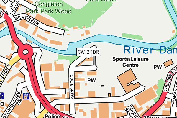
CW12 1DR lies on Park View in Congleton. CW12 1DR is located in the Congleton West electoral ward, within the unitary authority of Cheshire East and the English Parliamentary constituency of Congleton. The Sub Integrated Care Board (ICB) Location is NHS Cheshire and Merseyside ICB - 27D and the police force is Cheshire. This postcode has been in use since January 1980.


GetTheData
Source: OS OpenMap – Local (Ordnance Survey)
Source: OS VectorMap District (Ordnance Survey)
Licence: Open Government Licence (requires attribution)
| Easting | 386106 |
| Northing | 363221 |
| Latitude | 53.165923 |
| Longitude | -2.209279 |
GetTheData
Source: Open Postcode Geo
Licence: Open Government Licence
| Street | Park View |
| Town/City | Congleton |
| Country | England |
| Postcode District | CW12 |
➜ See where CW12 is on a map ➜ Where is Congleton? | |
GetTheData
Source: Land Registry Price Paid Data
Licence: Open Government Licence
Elevation or altitude of CW12 1DR as distance above sea level:
| Metres | Feet | |
|---|---|---|
| Elevation | 80m | 262ft |
Elevation is measured from the approximate centre of the postcode, to the nearest point on an OS contour line from OS Terrain 50, which has contour spacing of ten vertical metres.
➜ How high above sea level am I? Find the elevation of your current position using your device's GPS.
GetTheData
Source: Open Postcode Elevation
Licence: Open Government Licence
| Ward | Congleton West |
| Constituency | Congleton |
GetTheData
Source: ONS Postcode Database
Licence: Open Government Licence
| Spragg Street (Willow Street) | Congleton | 291m |
| Park Street (Moor Street) | Congleton | 304m |
| Antrobus Street (Mill Street) | Congleton | 308m |
| Antrobus Street (Mill Street) | Congleton | 329m |
| Fox Street (Brook Street) | Congleton | 343m |
| Congleton Station | 1.4km |
GetTheData
Source: NaPTAN
Licence: Open Government Licence
| Percentage of properties with Next Generation Access | 100.0% |
| Percentage of properties with Superfast Broadband | 100.0% |
| Percentage of properties with Ultrafast Broadband | 0.0% |
| Percentage of properties with Full Fibre Broadband | 0.0% |
Superfast Broadband is between 30Mbps and 300Mbps
Ultrafast Broadband is > 300Mbps
| Percentage of properties unable to receive 2Mbps | 0.0% |
| Percentage of properties unable to receive 5Mbps | 0.0% |
| Percentage of properties unable to receive 10Mbps | 0.0% |
| Percentage of properties unable to receive 30Mbps | 0.0% |
GetTheData
Source: Ofcom
Licence: Ofcom Terms of Use (requires attribution)
GetTheData
Source: ONS Postcode Database
Licence: Open Government Licence


➜ Get more ratings from the Food Standards Agency
GetTheData
Source: Food Standards Agency
Licence: FSA terms & conditions
| Last Collection | |||
|---|---|---|---|
| Location | Mon-Fri | Sat | Distance |
| Moor Street | 17:15 | 11:15 | 307m |
| West End Cottage | 17:30 | 11:45 | 341m |
| Harper Grove | 16:45 | 10:00 | 379m |
GetTheData
Source: Dracos
Licence: Creative Commons Attribution-ShareAlike
The below table lists the International Territorial Level (ITL) codes (formerly Nomenclature of Territorial Units for Statistics (NUTS) codes) and Local Administrative Units (LAU) codes for CW12 1DR:
| ITL 1 Code | Name |
|---|---|
| TLD | North West (England) |
| ITL 2 Code | Name |
| TLD6 | Cheshire |
| ITL 3 Code | Name |
| TLD62 | Cheshire East |
| LAU 1 Code | Name |
| E06000049 | Cheshire East |
GetTheData
Source: ONS Postcode Directory
Licence: Open Government Licence
The below table lists the Census Output Area (OA), Lower Layer Super Output Area (LSOA), and Middle Layer Super Output Area (MSOA) for CW12 1DR:
| Code | Name | |
|---|---|---|
| OA | E00092857 | |
| LSOA | E01018402 | Cheshire East 027C |
| MSOA | E02003816 | Cheshire East 027 |
GetTheData
Source: ONS Postcode Directory
Licence: Open Government Licence
| CW12 1DS | Park Road | 63m |
| CW12 1DP | Park Road | 120m |
| CW12 1GD | Mill Green | 157m |
| CW12 1DT | Worrall Street | 174m |
| CW12 1EA | The Meadows | 178m |
| CW12 1JG | Mill Green | 197m |
| CW12 1EH | Lower Park Street | 220m |
| CW12 1EE | Foundry Bank | 229m |
| CW12 1DE | Stonehouse Green | 232m |
| CW12 1FS | Mill Green | 248m |
GetTheData
Source: Open Postcode Geo; Land Registry Price Paid Data
Licence: Open Government Licence