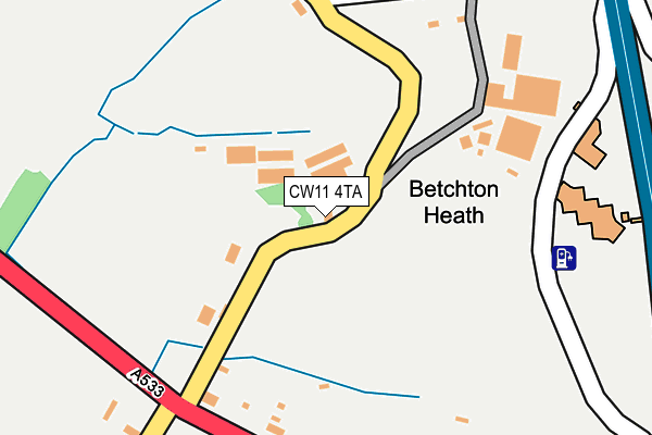
CW11 4TA lies on Betchton Heath in Betchton, Sandbach. CW11 4TA is located in the Brereton Rural electoral ward, within the unitary authority of Cheshire East and the English Parliamentary constituency of Congleton. The Sub Integrated Care Board (ICB) Location is NHS Cheshire and Merseyside ICB - 27D and the police force is Cheshire. This postcode has been in use since December 1995.


GetTheData
Source: OS OpenMap – Local (Ordnance Survey)
Source: OS VectorMap District (Ordnance Survey)
Licence: Open Government Licence (requires attribution)
| Easting | 377281 |
| Northing | 360301 |
| Latitude | 53.139388 |
| Longitude | -2.341071 |
GetTheData
Source: Open Postcode Geo
Licence: Open Government Licence
| Street | Betchton Heath |
| Locality | Betchton |
| Town/City | Sandbach |
| Country | England |
| Postcode District | CW11 |
➜ See where CW11 is on a map ➜ Where is Betchton Heath? | |
GetTheData
Source: Land Registry Price Paid Data
Licence: Open Government Licence
Elevation or altitude of CW11 4TA as distance above sea level:
| Metres | Feet | |
|---|---|---|
| Elevation | 70m | 230ft |
Elevation is measured from the approximate centre of the postcode, to the nearest point on an OS contour line from OS Terrain 50, which has contour spacing of ten vertical metres.
➜ How high above sea level am I? Find the elevation of your current position using your device's GPS.
GetTheData
Source: Open Postcode Elevation
Licence: Open Government Licence
| Ward | Brereton Rural |
| Constituency | Congleton |
GetTheData
Source: ONS Postcode Database
Licence: Open Government Licence
| Sandbach Services Coach Stop (Off M6) | Sandbach | 227m |
| Sandbach Services Coach Stop (Off M6) | Sandbach | 392m |
| Peartree Close (School Lane) | Sandbach Heath | 429m |
| Manor Park (Manor Road) | Sandbach Heath | 571m |
| Heath Road | Sandbach Heath | 576m |
| Sandbach Station | 3.7km |
GetTheData
Source: NaPTAN
Licence: Open Government Licence
| Percentage of properties with Next Generation Access | 100.0% |
| Percentage of properties with Superfast Broadband | 40.0% |
| Percentage of properties with Ultrafast Broadband | 0.0% |
| Percentage of properties with Full Fibre Broadband | 0.0% |
Superfast Broadband is between 30Mbps and 300Mbps
Ultrafast Broadband is > 300Mbps
| Median download speed | 16.1Mbps |
| Average download speed | 17.5Mbps |
| Maximum download speed | 40.00Mbps |
| Median upload speed | 2.9Mbps |
| Average upload speed | 3.1Mbps |
| Maximum upload speed | 7.03Mbps |
| Percentage of properties unable to receive 2Mbps | 0.0% |
| Percentage of properties unable to receive 5Mbps | 0.0% |
| Percentage of properties unable to receive 10Mbps | 0.0% |
| Percentage of properties unable to receive 30Mbps | 60.0% |
GetTheData
Source: Ofcom
Licence: Ofcom Terms of Use (requires attribution)
GetTheData
Source: ONS Postcode Database
Licence: Open Government Licence


➜ Get more ratings from the Food Standards Agency
GetTheData
Source: Food Standards Agency
Licence: FSA terms & conditions
| Last Collection | |||
|---|---|---|---|
| Location | Mon-Fri | Sat | Distance |
| M6 Services | 16:30 | 12:15 | 340m |
| Sandbach Post Office | 18:15 | 12:30 | 1,510m |
| St Georges Walk | 18:30 | 1,517m | |
GetTheData
Source: Dracos
Licence: Creative Commons Attribution-ShareAlike
The below table lists the International Territorial Level (ITL) codes (formerly Nomenclature of Territorial Units for Statistics (NUTS) codes) and Local Administrative Units (LAU) codes for CW11 4TA:
| ITL 1 Code | Name |
|---|---|
| TLD | North West (England) |
| ITL 2 Code | Name |
| TLD6 | Cheshire |
| ITL 3 Code | Name |
| TLD62 | Cheshire East |
| LAU 1 Code | Name |
| E06000049 | Cheshire East |
GetTheData
Source: ONS Postcode Directory
Licence: Open Government Licence
The below table lists the Census Output Area (OA), Lower Layer Super Output Area (LSOA), and Middle Layer Super Output Area (MSOA) for CW11 4TA:
| Code | Name | |
|---|---|---|
| OA | E00092933 | |
| LSOA | E01018418 | Cheshire East 033C |
| MSOA | E02003822 | Cheshire East 033 |
GetTheData
Source: ONS Postcode Directory
Licence: Open Government Licence
| CW11 2WE | Newcastle Road | 222m |
| CW11 2LU | Manor Road | 229m |
| CW11 2NB | Manor Road | 326m |
| CW11 2LZ | Brookland Drive | 359m |
| CW11 2LY | St Johns Way | 387m |
| CW11 2LS | School Lane | 428m |
| CW11 2LT | Pear Tree Close | 481m |
| CW11 2LD | Heath Avenue | 486m |
| CW11 2LX | Brookland Drive | 500m |
| CW11 2LA | Bailey Crescent | 525m |
GetTheData
Source: Open Postcode Geo; Land Registry Price Paid Data
Licence: Open Government Licence