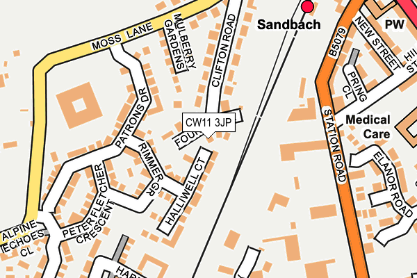
CW11 3JP lies on Foundry Lane in Sandbach. CW11 3JP is located in the Sandbach Elworth electoral ward, within the unitary authority of Cheshire East and the English Parliamentary constituency of Congleton. The Sub Integrated Care Board (ICB) Location is NHS Cheshire and Merseyside ICB - 27D and the police force is Cheshire. This postcode has been in use since December 1995.


GetTheData
Source: OS OpenMap – Local (Ordnance Survey)
Source: OS VectorMap District (Ordnance Survey)
Licence: Open Government Licence (requires attribution)
| Easting | 373630 |
| Northing | 361336 |
| Latitude | 53.148505 |
| Longitude | -2.395733 |
GetTheData
Source: Open Postcode Geo
Licence: Open Government Licence
| Street | Foundry Lane |
| Town/City | Sandbach |
| Country | England |
| Postcode District | CW11 |
➜ See where CW11 is on a map ➜ Where is Elworth? | |
GetTheData
Source: Land Registry Price Paid Data
Licence: Open Government Licence
Elevation or altitude of CW11 3JP as distance above sea level:
| Metres | Feet | |
|---|---|---|
| Elevation | 60m | 197ft |
Elevation is measured from the approximate centre of the postcode, to the nearest point on an OS contour line from OS Terrain 50, which has contour spacing of ten vertical metres.
➜ How high above sea level am I? Find the elevation of your current position using your device's GPS.
GetTheData
Source: Open Postcode Elevation
Licence: Open Government Licence
| Ward | Sandbach Elworth |
| Constituency | Congleton |
GetTheData
Source: ONS Postcode Database
Licence: Open Government Licence
2018 27 NOV £236,000 |
2018 31 OCT £240,000 |
2018 16 AUG £240,000 |
2015 14 AUG £248,000 |
5, FOUNDRY LANE, SANDBACH, CW11 3JP 2015 26 JUN £268,995 |
2015 30 APR £245,000 |
KNIGHTSHULME, FOUNDRY LANE, SANDBACH, CW11 3JP 2008 17 JAN £495,000 |
KNIGHTSHULME, FOUNDRY LANE, SANDBACH, CW11 3JP 2006 30 JUN £495,000 |
KNIGHTSHULME, FOUNDRY LANE, SANDBACH, CW11 3JP 1997 3 JUL £57,500 |
GetTheData
Source: HM Land Registry Price Paid Data
Licence: Contains HM Land Registry data © Crown copyright and database right 2025. This data is licensed under the Open Government Licence v3.0.
| Railway Station (Station Road) | Elworth | 240m |
| Railway Station (Station Road) | Elworth | 275m |
| Railway Station (London Road) | Elworth | 333m |
| Railway Station (London Road) | Elworth | 354m |
| Primary School (Middlewich Road) | Elworth | 447m |
| Sandbach Station | 0.2km |
GetTheData
Source: NaPTAN
Licence: Open Government Licence
| Percentage of properties with Next Generation Access | 100.0% |
| Percentage of properties with Superfast Broadband | 100.0% |
| Percentage of properties with Ultrafast Broadband | 0.0% |
| Percentage of properties with Full Fibre Broadband | 0.0% |
Superfast Broadband is between 30Mbps and 300Mbps
Ultrafast Broadband is > 300Mbps
| Median download speed | 55.0Mbps |
| Average download speed | 51.7Mbps |
| Maximum download speed | 80.00Mbps |
| Median upload speed | 10.0Mbps |
| Average upload speed | 12.2Mbps |
| Maximum upload speed | 20.00Mbps |
| Percentage of properties unable to receive 2Mbps | 0.0% |
| Percentage of properties unable to receive 5Mbps | 0.0% |
| Percentage of properties unable to receive 10Mbps | 0.0% |
| Percentage of properties unable to receive 30Mbps | 0.0% |
GetTheData
Source: Ofcom
Licence: Ofcom Terms of Use (requires attribution)
GetTheData
Source: ONS Postcode Database
Licence: Open Government Licence


➜ Get more ratings from the Food Standards Agency
GetTheData
Source: Food Standards Agency
Licence: FSA terms & conditions
| Last Collection | |||
|---|---|---|---|
| Location | Mon-Fri | Sat | Distance |
| Elworth So | 17:00 | 11:00 | 363m |
| The Avenue | 17:00 | 11:30 | 576m |
| St Peters Rise | 17:30 | 11:30 | 733m |
GetTheData
Source: Dracos
Licence: Creative Commons Attribution-ShareAlike
The below table lists the International Territorial Level (ITL) codes (formerly Nomenclature of Territorial Units for Statistics (NUTS) codes) and Local Administrative Units (LAU) codes for CW11 3JP:
| ITL 1 Code | Name |
|---|---|
| TLD | North West (England) |
| ITL 2 Code | Name |
| TLD6 | Cheshire |
| ITL 3 Code | Name |
| TLD62 | Cheshire East |
| LAU 1 Code | Name |
| E06000049 | Cheshire East |
GetTheData
Source: ONS Postcode Directory
Licence: Open Government Licence
The below table lists the Census Output Area (OA), Lower Layer Super Output Area (LSOA), and Middle Layer Super Output Area (MSOA) for CW11 3JP:
| Code | Name | |
|---|---|---|
| OA | E00093057 | |
| LSOA | E01018440 | Cheshire East 031A |
| MSOA | E02003820 | Cheshire East 031 |
GetTheData
Source: ONS Postcode Directory
Licence: Open Government Licence
| CW11 3AQ | Halliwell Court | 103m |
| CW11 3AF | Rimmer Grove | 106m |
| CW11 3GN | Mulberry Gardens | 124m |
| CW11 3JJ | Clifton Road | 125m |
| CW11 3JG | Station Road | 144m |
| CW11 3GW | Moss Lane | 169m |
| CW11 3AS | Patrons Drive | 197m |
| CW11 3AP | Peter Fletcher Crescent | 197m |
| CW11 3JW | Moss Lane | 206m |
| CW11 3FT | Elizabeth Close | 211m |
GetTheData
Source: Open Postcode Geo; Land Registry Price Paid Data
Licence: Open Government Licence