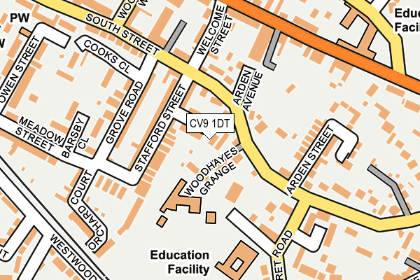
CV9 1DT is located in the Atherstone South and Mancetter electoral ward, within the local authority district of North Warwickshire and the English Parliamentary constituency of North Warwickshire. The Sub Integrated Care Board (ICB) Location is NHS Coventry and Warwickshire ICB - B2M3M and the police force is Warwickshire. This postcode has been in use since January 1980.


GetTheData
Source: OS OpenMap – Local (Ordnance Survey)
Source: OS VectorMap District (Ordnance Survey)
Licence: Open Government Licence (requires attribution)
| Easting | 431081 |
| Northing | 297479 |
| Latitude | 52.574265 |
| Longitude | -1.542802 |
GetTheData
Source: Open Postcode Geo
Licence: Open Government Licence
| Country | England |
| Postcode District | CV9 |
➜ See where CV9 is on a map ➜ Where is Atherstone? | |
GetTheData
Source: Land Registry Price Paid Data
Licence: Open Government Licence
Elevation or altitude of CV9 1DT as distance above sea level:
| Metres | Feet | |
|---|---|---|
| Elevation | 90m | 295ft |
Elevation is measured from the approximate centre of the postcode, to the nearest point on an OS contour line from OS Terrain 50, which has contour spacing of ten vertical metres.
➜ How high above sea level am I? Find the elevation of your current position using your device's GPS.
GetTheData
Source: Open Postcode Elevation
Licence: Open Government Licence
| Ward | Atherstone South And Mancetter |
| Constituency | North Warwickshire |
GetTheData
Source: ONS Postcode Database
Licence: Open Government Licence
| Arden Avenue (South Street) | Atherstone | 82m |
| New Dolphin Inn (Long Street) | Atherstone | 188m |
| New Dolphin Inn (Long Street) | Atherstone | 205m |
| Woolpack Way (South Street) | Atherstone | 245m |
| Tannery Close (North Street) | Atherstone | 305m |
| Atherstone Station | 0.9km |
GetTheData
Source: NaPTAN
Licence: Open Government Licence
| Percentage of properties with Next Generation Access | 100.0% |
| Percentage of properties with Superfast Broadband | 100.0% |
| Percentage of properties with Ultrafast Broadband | 100.0% |
| Percentage of properties with Full Fibre Broadband | 0.0% |
Superfast Broadband is between 30Mbps and 300Mbps
Ultrafast Broadband is > 300Mbps
| Percentage of properties unable to receive 2Mbps | 0.0% |
| Percentage of properties unable to receive 5Mbps | 0.0% |
| Percentage of properties unable to receive 10Mbps | 0.0% |
| Percentage of properties unable to receive 30Mbps | 0.0% |
GetTheData
Source: Ofcom
Licence: Ofcom Terms of Use (requires attribution)
GetTheData
Source: ONS Postcode Database
Licence: Open Government Licence


➜ Get more ratings from the Food Standards Agency
GetTheData
Source: Food Standards Agency
Licence: FSA terms & conditions
| Last Collection | |||
|---|---|---|---|
| Location | Mon-Fri | Sat | Distance |
| South Street | 18:30 | 09:00 | 103m |
| Atherstone | 18:45 | 12:15 | 382m |
| Atherstone Delivery Office | 18:45 | 12:15 | 382m |
GetTheData
Source: Dracos
Licence: Creative Commons Attribution-ShareAlike
The below table lists the International Territorial Level (ITL) codes (formerly Nomenclature of Territorial Units for Statistics (NUTS) codes) and Local Administrative Units (LAU) codes for CV9 1DT:
| ITL 1 Code | Name |
|---|---|
| TLG | West Midlands (England) |
| ITL 2 Code | Name |
| TLG1 | Herefordshire, Worcestershire and Warwickshire |
| ITL 3 Code | Name |
| TLG13 | Warwickshire CC |
| LAU 1 Code | Name |
| E07000218 | North Warwickshire |
GetTheData
Source: ONS Postcode Directory
Licence: Open Government Licence
The below table lists the Census Output Area (OA), Lower Layer Super Output Area (LSOA), and Middle Layer Super Output Area (MSOA) for CV9 1DT:
| Code | Name | |
|---|---|---|
| OA | E00158095 | |
| LSOA | E01031013 | North Warwickshire 003E |
| MSOA | E02006470 | North Warwickshire 003 |
GetTheData
Source: ONS Postcode Directory
Licence: Open Government Licence
| CV9 1DS | Stratton Street | 35m |
| CV9 1DZ | South Street | 45m |
| CV9 1DY | South Street | 60m |
| CV9 1DW | Stafford Street | 76m |
| CV9 1DN | Stafford Street | 83m |
| CV9 1EA | Arden Avenue | 99m |
| CV9 1EW | School Court | 102m |
| CV9 1DP | Grove Road | 120m |
| CV9 1DR | South Street | 120m |
| CV9 1DX | Welcome Street | 123m |
GetTheData
Source: Open Postcode Geo; Land Registry Price Paid Data
Licence: Open Government Licence