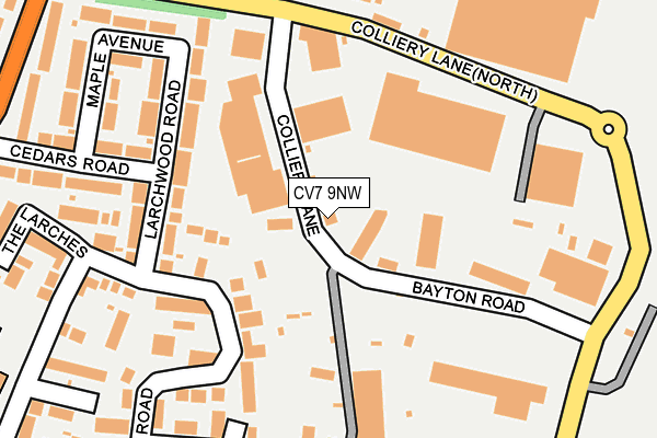
CV7 9NW lies on Colliery Lane in Exhall, Coventry. CV7 9NW is located in the Poplar electoral ward, within the local authority district of Nuneaton and Bedworth and the English Parliamentary constituency of North Warwickshire. The Sub Integrated Care Board (ICB) Location is NHS Coventry and Warwickshire ICB - B2M3M and the police force is Warwickshire. This postcode has been in use since January 1980.


GetTheData
Source: OS OpenMap – Local (Ordnance Survey)
Source: OS VectorMap District (Ordnance Survey)
Licence: Open Government Licence (requires attribution)
| Easting | 435818 |
| Northing | 285971 |
| Latitude | 52.470506 |
| Longitude | -1.474152 |
GetTheData
Source: Open Postcode Geo
Licence: Open Government Licence
| Street | Colliery Lane |
| Locality | Exhall |
| Town/City | Coventry |
| Country | England |
| Postcode District | CV7 |
➜ See where CV7 is on a map ➜ Where is Bedworth? | |
GetTheData
Source: Land Registry Price Paid Data
Licence: Open Government Licence
Elevation or altitude of CV7 9NW as distance above sea level:
| Metres | Feet | |
|---|---|---|
| Elevation | 100m | 328ft |
Elevation is measured from the approximate centre of the postcode, to the nearest point on an OS contour line from OS Terrain 50, which has contour spacing of ten vertical metres.
➜ How high above sea level am I? Find the elevation of your current position using your device's GPS.
GetTheData
Source: Open Postcode Elevation
Licence: Open Government Licence
| Ward | Poplar |
| Constituency | North Warwickshire |
GetTheData
Source: ONS Postcode Database
Licence: Open Government Licence
GEOFF SIPSON COMMERCIALS LTD, COLLIERY LANE, EXHALL, COVENTRY, CV7 9NW 2004 28 MAY £400,000 |
GetTheData
Source: HM Land Registry Price Paid Data
Licence: Contains HM Land Registry data © Crown copyright and database right 2025. This data is licensed under the Open Government Licence v3.0.
| Excel (Colliery Lane) | Exhall | 161m |
| Excel (Colliery Lane) | Exhall | 169m |
| Colliery Lane (Colliery Lane North) | Bedworth | 173m |
| Colliery Lane (Colliery Lane North) | Exhall | 191m |
| Shearings (Bayton Road) | Exhall | 226m |
| Bedworth Station | 1.1km |
| Coventry Arena Station | 2.9km |
| Bermuda Park Station | 3.4km |
GetTheData
Source: NaPTAN
Licence: Open Government Licence
| Median download speed | 55.0Mbps |
| Average download speed | 50.0Mbps |
| Maximum download speed | 80.00Mbps |
| Median upload speed | 13.7Mbps |
| Average upload speed | 12.3Mbps |
| Maximum upload speed | 20.00Mbps |
GetTheData
Source: Ofcom
Licence: Ofcom Terms of Use (requires attribution)
GetTheData
Source: ONS Postcode Database
Licence: Open Government Licence


➜ Get more ratings from the Food Standards Agency
GetTheData
Source: Food Standards Agency
Licence: FSA terms & conditions
| Last Collection | |||
|---|---|---|---|
| Location | Mon-Fri | Sat | Distance |
| Tregorrick Road | 17:30 | 11:15 | 481m |
| Coventry Road | 16:15 | 12:15 | 496m |
| Thompsons Road | 16:00 | 11:30 | 616m |
GetTheData
Source: Dracos
Licence: Creative Commons Attribution-ShareAlike
The below table lists the International Territorial Level (ITL) codes (formerly Nomenclature of Territorial Units for Statistics (NUTS) codes) and Local Administrative Units (LAU) codes for CV7 9NW:
| ITL 1 Code | Name |
|---|---|
| TLG | West Midlands (England) |
| ITL 2 Code | Name |
| TLG1 | Herefordshire, Worcestershire and Warwickshire |
| ITL 3 Code | Name |
| TLG13 | Warwickshire CC |
| LAU 1 Code | Name |
| E07000219 | Nuneaton and Bedworth |
GetTheData
Source: ONS Postcode Directory
Licence: Open Government Licence
The below table lists the Census Output Area (OA), Lower Layer Super Output Area (LSOA), and Middle Layer Super Output Area (MSOA) for CV7 9NW:
| Code | Name | |
|---|---|---|
| OA | E00158513 | |
| LSOA | E01031098 | Nuneaton and Bedworth 015D |
| MSOA | E02006489 | Nuneaton and Bedworth 015 |
GetTheData
Source: ONS Postcode Directory
Licence: Open Government Licence
| CV7 9PW | Tresillian Road | 122m |
| CV7 9GD | Larchwood Road | 145m |
| CV7 9FZ | Larchwood Road | 187m |
| CV7 9PP | Tresillian Road | 193m |
| CV7 9NQ | Rosemullion Close | 216m |
| CV7 9PL | Kenwyn Green | 231m |
| CV7 9NJ | Cedars Road | 242m |
| CV7 9AY | Maple Avenue | 246m |
| CV7 9NF | The Larches | 268m |
| CV7 9NP | Devoran Close | 312m |
GetTheData
Source: Open Postcode Geo; Land Registry Price Paid Data
Licence: Open Government Licence