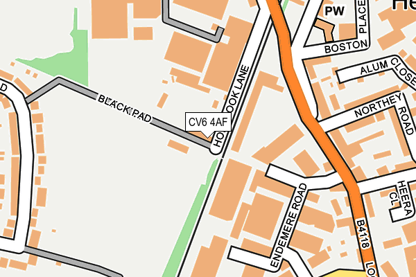
CV6 4AF is located in the Radford electoral ward, within the metropolitan district of Coventry and the English Parliamentary constituency of Coventry North West. The Sub Integrated Care Board (ICB) Location is NHS Coventry and Warwickshire ICB - B2M3M and the police force is West Midlands. This postcode has been in use since January 1980.


GetTheData
Source: OS OpenMap – Local (Ordnance Survey)
Source: OS VectorMap District (Ordnance Survey)
Licence: Open Government Licence (requires attribution)
| Easting | 433647 |
| Northing | 281592 |
| Latitude | 52.431295 |
| Longitude | -1.506542 |
GetTheData
Source: Open Postcode Geo
Licence: Open Government Licence
| Country | England |
| Postcode District | CV6 |
➜ See where CV6 is on a map ➜ Where is Coventry? | |
GetTheData
Source: Land Registry Price Paid Data
Licence: Open Government Licence
Elevation or altitude of CV6 4AF as distance above sea level:
| Metres | Feet | |
|---|---|---|
| Elevation | 100m | 328ft |
Elevation is measured from the approximate centre of the postcode, to the nearest point on an OS contour line from OS Terrain 50, which has contour spacing of ten vertical metres.
➜ How high above sea level am I? Find the elevation of your current position using your device's GPS.
GetTheData
Source: Open Postcode Elevation
Licence: Open Government Licence
| Ward | Radford |
| Constituency | Coventry North West |
GetTheData
Source: ONS Postcode Database
Licence: Open Government Licence
| Northey Rd (Lockhurst Lane) | Edgwick | 148m |
| Northey Rd (Lockhurst Lane) | Edgwick | 187m |
| Livingstone Rd (Lockhurst Lane) | Edgwick | 340m |
| Burnaby Rd (Holbrook Lane) | Whitmore Park | 352m |
| Holbrook Lane (Burnaby Rd) | Whitmore Park | 379m |
| Coventry Arena Station | 2km |
| Coventry Station | 3.4km |
| Canley Station | 4.5km |
GetTheData
Source: NaPTAN
Licence: Open Government Licence
GetTheData
Source: ONS Postcode Database
Licence: Open Government Licence

➜ Get more ratings from the Food Standards Agency
GetTheData
Source: Food Standards Agency
Licence: FSA terms & conditions
| Last Collection | |||
|---|---|---|---|
| Location | Mon-Fri | Sat | Distance |
| Durbar Avenue | 17:30 | 10:00 | 197m |
| Churchill Avenue | 17:15 | 10:15 | 597m |
| Great Heath Post Office | 18:45 | 11:30 | 600m |
GetTheData
Source: Dracos
Licence: Creative Commons Attribution-ShareAlike
The below table lists the International Territorial Level (ITL) codes (formerly Nomenclature of Territorial Units for Statistics (NUTS) codes) and Local Administrative Units (LAU) codes for CV6 4AF:
| ITL 1 Code | Name |
|---|---|
| TLG | West Midlands (England) |
| ITL 2 Code | Name |
| TLG3 | West Midlands |
| ITL 3 Code | Name |
| TLG33 | Coventry |
| LAU 1 Code | Name |
| E08000026 | Coventry |
GetTheData
Source: ONS Postcode Directory
Licence: Open Government Licence
The below table lists the Census Output Area (OA), Lower Layer Super Output Area (LSOA), and Middle Layer Super Output Area (MSOA) for CV6 4AF:
| Code | Name | |
|---|---|---|
| OA | E00048712 | |
| LSOA | E01009626 | Coventry 011D |
| MSOA | E02001968 | Coventry 011 |
GetTheData
Source: ONS Postcode Directory
Licence: Open Government Licence
| CV6 5NJ | Lockhurst Lane | 172m |
| CV6 5NQ | Lockhurst Lane | 233m |
| CV6 5NF | Northey Road | 237m |
| CV6 3GU | Blackwatch Road | 251m |
| CV6 5PR | Marion Road | 255m |
| CV6 5TQ | Alum Close | 263m |
| CV6 5PS | Kingfield Road | 269m |
| CV6 5NE | Northey Road | 275m |
| CV6 3GW | Blackwatch Road | 281m |
| CV6 5ND | Station Street West | 297m |
GetTheData
Source: Open Postcode Geo; Land Registry Price Paid Data
Licence: Open Government Licence