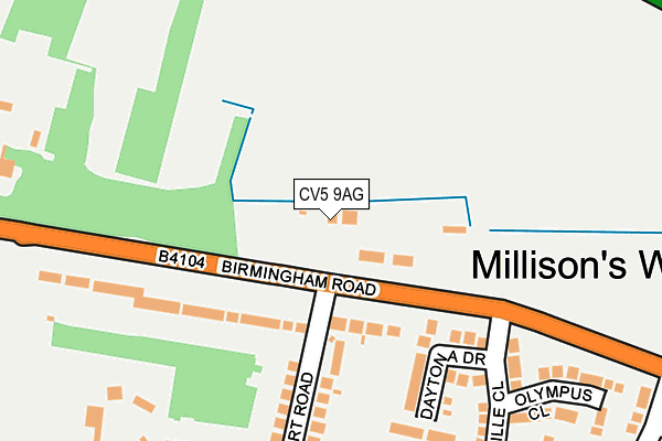
CV5 9AG lies on Birmingham Road in Millisons Wood, Coventry. CV5 9AG is located in the Meriden electoral ward, within the metropolitan district of Solihull and the English Parliamentary constituency of Meriden. The Sub Integrated Care Board (ICB) Location is NHS Birmingham and Solihull ICB - 15E and the police force is West Midlands. This postcode has been in use since September 2002.


GetTheData
Source: OS OpenMap – Local (Ordnance Survey)
Source: OS VectorMap District (Ordnance Survey)
Licence: Open Government Licence (requires attribution)
| Easting | 426493 |
| Northing | 281896 |
| Latitude | 52.434403 |
| Longitude | -1.611743 |
GetTheData
Source: Open Postcode Geo
Licence: Open Government Licence
| Street | Birmingham Road |
| Locality | Millisons Wood |
| Town/City | Coventry |
| Country | England |
| Postcode District | CV5 |
➜ See where CV5 is on a map ➜ Where is Millison's Wood? | |
GetTheData
Source: Land Registry Price Paid Data
Licence: Open Government Licence
Elevation or altitude of CV5 9AG as distance above sea level:
| Metres | Feet | |
|---|---|---|
| Elevation | 140m | 459ft |
Elevation is measured from the approximate centre of the postcode, to the nearest point on an OS contour line from OS Terrain 50, which has contour spacing of ten vertical metres.
➜ How high above sea level am I? Find the elevation of your current position using your device's GPS.
GetTheData
Source: Open Postcode Elevation
Licence: Open Government Licence
| Ward | Meriden |
| Constituency | Meriden |
GetTheData
Source: ONS Postcode Database
Licence: Open Government Licence
| Albert Rd (Birmingham Rd) | Millisons Wood | 50m |
| Albert Rd (Birmingham Rd) | Millisons Wood | 71m |
| James Dawson Drive (Birmingham Rd) | Pickford Green | 370m |
| James Dawson Drive (Birmingham Rd) | Pickford Green | 450m |
| A45 Bridge (Showell Lane) | Millisons Wood | 599m |
| Tile Hill Station | 4.5km |
| Berkswell Station | 4.8km |
| Canley Station | 5.9km |
GetTheData
Source: NaPTAN
Licence: Open Government Licence
| Percentage of properties with Next Generation Access | 100.0% |
| Percentage of properties with Superfast Broadband | 100.0% |
| Percentage of properties with Ultrafast Broadband | 0.0% |
| Percentage of properties with Full Fibre Broadband | 0.0% |
Superfast Broadband is between 30Mbps and 300Mbps
Ultrafast Broadband is > 300Mbps
| Percentage of properties unable to receive 2Mbps | 0.0% |
| Percentage of properties unable to receive 5Mbps | 0.0% |
| Percentage of properties unable to receive 10Mbps | 0.0% |
| Percentage of properties unable to receive 30Mbps | 0.0% |
GetTheData
Source: Ofcom
Licence: Ofcom Terms of Use (requires attribution)
GetTheData
Source: ONS Postcode Database
Licence: Open Government Licence


➜ Get more ratings from the Food Standards Agency
GetTheData
Source: Food Standards Agency
Licence: FSA terms & conditions
| Last Collection | |||
|---|---|---|---|
| Location | Mon-Fri | Sat | Distance |
| Millisons Wood | 17:30 | 09:45 | 67m |
| Royal Oak | 16:00 | 09:45 | 716m |
| Eaves Green | 17:15 | 10:00 | 966m |
GetTheData
Source: Dracos
Licence: Creative Commons Attribution-ShareAlike
The below table lists the International Territorial Level (ITL) codes (formerly Nomenclature of Territorial Units for Statistics (NUTS) codes) and Local Administrative Units (LAU) codes for CV5 9AG:
| ITL 1 Code | Name |
|---|---|
| TLG | West Midlands (England) |
| ITL 2 Code | Name |
| TLG3 | West Midlands |
| ITL 3 Code | Name |
| TLG32 | Solihull |
| LAU 1 Code | Name |
| E08000029 | Solihull |
GetTheData
Source: ONS Postcode Directory
Licence: Open Government Licence
The below table lists the Census Output Area (OA), Lower Layer Super Output Area (LSOA), and Middle Layer Super Output Area (MSOA) for CV5 9AG:
| Code | Name | |
|---|---|---|
| OA | E00051417 | |
| LSOA | E01010164 | Solihull 017B |
| MSOA | E02002097 | Solihull 017 |
GetTheData
Source: ONS Postcode Directory
Licence: Open Government Licence
| CV5 9AY | Birmingham Road | 119m |
| CV5 9QG | Daytona Drive | 193m |
| CV5 9AS | Albert Road | 211m |
| CV5 9AT | Grace Road | 254m |
| CV5 9QH | Bonneville Close | 270m |
| CV5 9QQ | Olympus Close | 281m |
| CV5 9QN | Armarna Drive | 302m |
| CV5 9QL | Luxor Lane | 396m |
| CV5 9QJ | James Dawson Drive | 398m |
| CV5 9QW | Thebes Close | 410m |
GetTheData
Source: Open Postcode Geo; Land Registry Price Paid Data
Licence: Open Government Licence