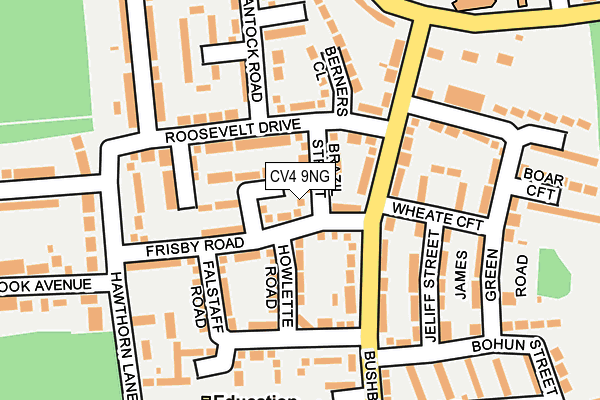
CV4 9NG is located in the Woodlands electoral ward, within the metropolitan district of Coventry and the English Parliamentary constituency of Coventry North West. The Sub Integrated Care Board (ICB) Location is NHS Coventry and Warwickshire ICB - B2M3M and the police force is West Midlands. This postcode has been in use since January 1980.


GetTheData
Source: OS OpenMap – Local (Ordnance Survey)
Source: OS VectorMap District (Ordnance Survey)
Licence: Open Government Licence (requires attribution)
| Easting | 428475 |
| Northing | 278618 |
| Latitude | 52.404835 |
| Longitude | -1.582869 |
GetTheData
Source: Open Postcode Geo
Licence: Open Government Licence
| Country | England |
| Postcode District | CV4 |
➜ See where CV4 is on a map ➜ Where is Coventry? | |
GetTheData
Source: Land Registry Price Paid Data
Licence: Open Government Licence
Elevation or altitude of CV4 9NG as distance above sea level:
| Metres | Feet | |
|---|---|---|
| Elevation | 110m | 361ft |
Elevation is measured from the approximate centre of the postcode, to the nearest point on an OS contour line from OS Terrain 50, which has contour spacing of ten vertical metres.
➜ How high above sea level am I? Find the elevation of your current position using your device's GPS.
GetTheData
Source: Open Postcode Elevation
Licence: Open Government Licence
| Ward | Woodlands |
| Constituency | Coventry North West |
GetTheData
Source: ONS Postcode Database
Licence: Open Government Licence
| Brazil St (Roosevelt Dr) | Tile Hill North | 69m |
| Frisby Rd (Bushbery Avenue) | Tile Hill North | 70m |
| Frisby Rd (Bushbery Avenue) | Tile Hill North | 83m |
| Brazil St (Roosevelt Dr) | Tile Hill North | 87m |
| Jardine Crescent (Bushbery Avenue) | Tile Hill North | 199m |
| Tile Hill Station | 1.4km |
| Canley Station | 2.5km |
| Berkswell Station | 4.2km |
GetTheData
Source: NaPTAN
Licence: Open Government Licence
| Percentage of properties with Next Generation Access | 100.0% |
| Percentage of properties with Superfast Broadband | 100.0% |
| Percentage of properties with Ultrafast Broadband | 100.0% |
| Percentage of properties with Full Fibre Broadband | 100.0% |
Superfast Broadband is between 30Mbps and 300Mbps
Ultrafast Broadband is > 300Mbps
| Percentage of properties unable to receive 2Mbps | 0.0% |
| Percentage of properties unable to receive 5Mbps | 0.0% |
| Percentage of properties unable to receive 10Mbps | 0.0% |
| Percentage of properties unable to receive 30Mbps | 0.0% |
GetTheData
Source: Ofcom
Licence: Ofcom Terms of Use (requires attribution)
GetTheData
Source: ONS Postcode Database
Licence: Open Government Licence


➜ Get more ratings from the Food Standards Agency
GetTheData
Source: Food Standards Agency
Licence: FSA terms & conditions
| Last Collection | |||
|---|---|---|---|
| Location | Mon-Fri | Sat | Distance |
| Jardine Crescent Post Office | 17:00 | 11:30 | 553m |
| Jobs Lane | 17:00 | 09:45 | 731m |
| Broad Lane | 17:30 | 11:15 | 788m |
GetTheData
Source: Dracos
Licence: Creative Commons Attribution-ShareAlike
The below table lists the International Territorial Level (ITL) codes (formerly Nomenclature of Territorial Units for Statistics (NUTS) codes) and Local Administrative Units (LAU) codes for CV4 9NG:
| ITL 1 Code | Name |
|---|---|
| TLG | West Midlands (England) |
| ITL 2 Code | Name |
| TLG3 | West Midlands |
| ITL 3 Code | Name |
| TLG33 | Coventry |
| LAU 1 Code | Name |
| E08000026 | Coventry |
GetTheData
Source: ONS Postcode Directory
Licence: Open Government Licence
The below table lists the Census Output Area (OA), Lower Layer Super Output Area (LSOA), and Middle Layer Super Output Area (MSOA) for CV4 9NG:
| Code | Name | |
|---|---|---|
| OA | E00049077 | |
| LSOA | E01009701 | Coventry 029D |
| MSOA | E02001986 | Coventry 029 |
GetTheData
Source: ONS Postcode Directory
Licence: Open Government Licence
| CV4 9NE | Brazil Street | 43m |
| CV4 9LF | Frisby Road | 63m |
| CV4 9LH | Howlette Road | 77m |
| CV4 9NN | Bushberry Avenue | 93m |
| CV4 9LP | Roosevelt Drive | 95m |
| CV4 9LJ | Roosevelt Drive | 104m |
| CV4 9NF | Bantock Road | 107m |
| CV4 9LN | Roosevelt Drive | 121m |
| CV4 9SH | Wheate Croft | 124m |
| CV4 9RY | Falstaff Road | 132m |
GetTheData
Source: Open Postcode Geo; Land Registry Price Paid Data
Licence: Open Government Licence