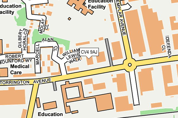
CV4 9AJ is located in the Westwood electoral ward, within the metropolitan district of Coventry and the English Parliamentary constituency of Coventry South. The Sub Integrated Care Board (ICB) Location is NHS Coventry and Warwickshire ICB - B2M3M and the police force is West Midlands. This postcode has been in use since July 1995.


GetTheData
Source: OS OpenMap – Local (Ordnance Survey)
Source: OS VectorMap District (Ordnance Survey)
Licence: Open Government Licence (requires attribution)
| Easting | 429095 |
| Northing | 277895 |
| Latitude | 52.398319 |
| Longitude | -1.573809 |
GetTheData
Source: Open Postcode Geo
Licence: Open Government Licence
| Country | England |
| Postcode District | CV4 |
➜ See where CV4 is on a map ➜ Where is Coventry? | |
GetTheData
Source: Land Registry Price Paid Data
Licence: Open Government Licence
Elevation or altitude of CV4 9AJ as distance above sea level:
| Metres | Feet | |
|---|---|---|
| Elevation | 100m | 328ft |
Elevation is measured from the approximate centre of the postcode, to the nearest point on an OS contour line from OS Terrain 50, which has contour spacing of ten vertical metres.
➜ How high above sea level am I? Find the elevation of your current position using your device's GPS.
GetTheData
Source: Open Postcode Elevation
Licence: Open Government Licence
| Ward | Westwood |
| Constituency | Coventry South |
GetTheData
Source: ONS Postcode Database
Licence: Open Government Licence
| Wolfe Rd (Torrington Ave) | Tile Hill North | 26m |
| Wolfe Rd (Torrington Ave) | Tile Hill North | 168m |
| Templar Avenue (Torrington Ave) | Tile Hill North | 189m |
| Templar Avenue (Torrington Ave) | Tile Hill North | 311m |
| Hancock Green (Wolfe Rd) | Westwood Business Park | 348m |
| Tile Hill Station | 1.6km |
| Canley Station | 1.8km |
| Coventry Station | 4.1km |
GetTheData
Source: NaPTAN
Licence: Open Government Licence
| Percentage of properties with Next Generation Access | 0.0% |
| Percentage of properties with Superfast Broadband | 0.0% |
| Percentage of properties with Ultrafast Broadband | 0.0% |
| Percentage of properties with Full Fibre Broadband | 0.0% |
Superfast Broadband is between 30Mbps and 300Mbps
Ultrafast Broadband is > 300Mbps
| Median download speed | 13.9Mbps |
| Average download speed | 18.1Mbps |
| Maximum download speed | 70.44Mbps |
| Median upload speed | 0.8Mbps |
| Average upload speed | 3.2Mbps |
| Maximum upload speed | 19.94Mbps |
| Percentage of properties unable to receive 2Mbps | 0.0% |
| Percentage of properties unable to receive 5Mbps | 0.0% |
| Percentage of properties unable to receive 10Mbps | 0.0% |
| Percentage of properties unable to receive 30Mbps | 100.0% |
GetTheData
Source: Ofcom
Licence: Ofcom Terms of Use (requires attribution)
GetTheData
Source: ONS Postcode Database
Licence: Open Government Licence


➜ Get more ratings from the Food Standards Agency
GetTheData
Source: Food Standards Agency
Licence: FSA terms & conditions
| Last Collection | |||
|---|---|---|---|
| Location | Mon-Fri | Sat | Distance |
| Torrington Avenue | 16:30 | 09:45 | 295m |
| Jobs Lane | 17:00 | 09:45 | 553m |
| Standard Avenue | 16:30 | 11:45 | 782m |
GetTheData
Source: Dracos
Licence: Creative Commons Attribution-ShareAlike
The below table lists the International Territorial Level (ITL) codes (formerly Nomenclature of Territorial Units for Statistics (NUTS) codes) and Local Administrative Units (LAU) codes for CV4 9AJ:
| ITL 1 Code | Name |
|---|---|
| TLG | West Midlands (England) |
| ITL 2 Code | Name |
| TLG3 | West Midlands |
| ITL 3 Code | Name |
| TLG33 | Coventry |
| LAU 1 Code | Name |
| E08000026 | Coventry |
GetTheData
Source: ONS Postcode Directory
Licence: Open Government Licence
The below table lists the Census Output Area (OA), Lower Layer Super Output Area (LSOA), and Middle Layer Super Output Area (MSOA) for CV4 9AJ:
| Code | Name | |
|---|---|---|
| OA | E00048974 | |
| LSOA | E01009676 | Coventry 032A |
| MSOA | E02001989 | Coventry 032 |
GetTheData
Source: ONS Postcode Directory
Licence: Open Government Licence
| CV4 9YP | Molay Close | 172m |
| CV4 9AP | Torrington Avenue | 188m |
| CV4 9TJ | Torrington Avenue | 207m |
| CV4 9UP | Wolfe Road | 238m |
| CV4 9YA | Tremelay Drive | 243m |
| CV4 9YH | Ridefort Close | 258m |
| CV4 9BP | Templar Avenue | 277m |
| CV4 9HD | Meadowcroft Close | 278m |
| CV4 9HF | Hedgefield Way | 295m |
| CV4 9YE | Montbard Close | 298m |
GetTheData
Source: Open Postcode Geo; Land Registry Price Paid Data
Licence: Open Government Licence