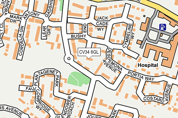
CV34 6GL lies on Parolles Close in Heathcote, Warwick. CV34 6GL is located in the Warwick Myton & Heathcote electoral ward, within the local authority district of Warwick and the English Parliamentary constituency of Warwick and Leamington. The Sub Integrated Care Board (ICB) Location is NHS Coventry and Warwickshire ICB - B2M3M and the police force is Warwickshire. This postcode has been in use since December 2001.


GetTheData
Source: OS OpenMap – Local (Ordnance Survey)
Source: OS VectorMap District (Ordnance Survey)
Licence: Open Government Licence (requires attribution)
| Easting | 431224 |
| Northing | 263446 |
| Latitude | 52.268306 |
| Longitude | -1.543856 |
GetTheData
Source: Open Postcode Geo
Licence: Open Government Licence
| Street | Parolles Close |
| Locality | Heathcote |
| Town/City | Warwick |
| Country | England |
| Postcode District | CV34 |
➜ See where CV34 is on a map ➜ Where is Warwick? | |
GetTheData
Source: Land Registry Price Paid Data
Licence: Open Government Licence
Elevation or altitude of CV34 6GL as distance above sea level:
| Metres | Feet | |
|---|---|---|
| Elevation | 70m | 230ft |
Elevation is measured from the approximate centre of the postcode, to the nearest point on an OS contour line from OS Terrain 50, which has contour spacing of ten vertical metres.
➜ How high above sea level am I? Find the elevation of your current position using your device's GPS.
GetTheData
Source: Open Postcode Elevation
Licence: Open Government Licence
| Ward | Warwick Myton & Heathcote |
| Constituency | Warwick And Leamington |
GetTheData
Source: ONS Postcode Database
Licence: Open Government Licence
18, PAROLLES CLOSE, HEATHCOTE, WARWICK, CV34 6GL 2007 23 AUG £199,950 |
18, PAROLLES CLOSE, HEATHCOTE, WARWICK, CV34 6GL 2001 20 SEP £113,500 |
GetTheData
Source: HM Land Registry Price Paid Data
Licence: Contains HM Land Registry data © Crown copyright and database right 2025. This data is licensed under the Open Government Licence v3.0.
| Ophelia Drive (Portia Way) | Warwick Gates | 94m |
| Ophelia Drive | Warwick Gates | 134m |
| Jourdain Park (Ophelia Drive) | Warwick Gates | 219m |
| Falstaff Grove (Ophelia Way) | Warwick Gates | 256m |
| Tachbrook Park Drive (Heathcote Lane) | Warwick Gates | 298m |
| Leamington Spa Station | 1.9km |
| Warwick Station | 3.3km |
| Warwick Parkway Station | 5.1km |
GetTheData
Source: NaPTAN
Licence: Open Government Licence
| Percentage of properties with Next Generation Access | 100.0% |
| Percentage of properties with Superfast Broadband | 100.0% |
| Percentage of properties with Ultrafast Broadband | 84.6% |
| Percentage of properties with Full Fibre Broadband | 0.0% |
Superfast Broadband is between 30Mbps and 300Mbps
Ultrafast Broadband is > 300Mbps
| Median download speed | 70.2Mbps |
| Average download speed | 61.6Mbps |
| Maximum download speed | 100.00Mbps |
| Median upload speed | 19.2Mbps |
| Average upload speed | 14.7Mbps |
| Maximum upload speed | 20.00Mbps |
| Percentage of properties unable to receive 2Mbps | 0.0% |
| Percentage of properties unable to receive 5Mbps | 0.0% |
| Percentage of properties unable to receive 10Mbps | 0.0% |
| Percentage of properties unable to receive 30Mbps | 0.0% |
GetTheData
Source: Ofcom
Licence: Ofcom Terms of Use (requires attribution)
Estimated total energy consumption in CV34 6GL by fuel type, 2015.
| Consumption (kWh) | 65,049 |
|---|---|
| Meter count | 9 |
| Mean (kWh/meter) | 7,228 |
| Median (kWh/meter) | 6,204 |
| Consumption (kWh) | 19,102 |
|---|---|
| Meter count | 8 |
| Mean (kWh/meter) | 2,388 |
| Median (kWh/meter) | 2,149 |
GetTheData
Source: Postcode level gas estimates: 2015 (experimental)
Source: Postcode level electricity estimates: 2015 (experimental)
Licence: Open Government Licence
GetTheData
Source: ONS Postcode Database
Licence: Open Government Licence


➜ Get more ratings from the Food Standards Agency
GetTheData
Source: Food Standards Agency
Licence: FSA terms & conditions
| Last Collection | |||
|---|---|---|---|
| Location | Mon-Fri | Sat | Distance |
| Romeo Arbour | 17:00 | 10:30 | 338m |
| Cressida Close | 17:00 | 10:00 | 354m |
| Collins Road Business Box | 627m | ||
GetTheData
Source: Dracos
Licence: Creative Commons Attribution-ShareAlike
The below table lists the International Territorial Level (ITL) codes (formerly Nomenclature of Territorial Units for Statistics (NUTS) codes) and Local Administrative Units (LAU) codes for CV34 6GL:
| ITL 1 Code | Name |
|---|---|
| TLG | West Midlands (England) |
| ITL 2 Code | Name |
| TLG1 | Herefordshire, Worcestershire and Warwickshire |
| ITL 3 Code | Name |
| TLG13 | Warwickshire CC |
| LAU 1 Code | Name |
| E07000222 | Warwick |
GetTheData
Source: ONS Postcode Directory
Licence: Open Government Licence
The below table lists the Census Output Area (OA), Lower Layer Super Output Area (LSOA), and Middle Layer Super Output Area (MSOA) for CV34 6GL:
| Code | Name | |
|---|---|---|
| OA | E00172311 | |
| LSOA | E01031315 | Warwick 012A |
| MSOA | E02006530 | Warwick 012 |
GetTheData
Source: ONS Postcode Directory
Licence: Open Government Licence
| CV34 6FX | Desdemona Avenue | 55m |
| CV34 6GQ | Cleopatra Grove | 136m |
| CV34 6FW | Chatillon Close | 139m |
| CV34 6GJ | Bushy End | 142m |
| CV34 6GH | Jack Cade Way | 145m |
| CV34 6FQ | Cymbeline Way | 152m |
| CV34 6EX | Plantagenet Park | 155m |
| CV34 6XG | Lear Grove | 160m |
| CV34 6XJ | Ophelia Drive | 164m |
| CV34 6ET | Glendower Approach | 175m |
GetTheData
Source: Open Postcode Geo; Land Registry Price Paid Data
Licence: Open Government Licence