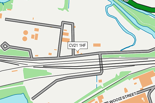
CV21 1HF is located in the Newbold and Brownsover electoral ward, within the local authority district of Rugby and the English Parliamentary constituency of Rugby. The Sub Integrated Care Board (ICB) Location is NHS Coventry and Warwickshire ICB - B2M3M and the police force is Warwickshire. This postcode has been in use since January 1980.


GetTheData
Source: OS OpenMap – Local (Ordnance Survey)
Source: OS VectorMap District (Ordnance Survey)
Licence: Open Government Licence (requires attribution)
| Easting | 449667 |
| Northing | 276147 |
| Latitude | 52.381131 |
| Longitude | -1.271740 |
GetTheData
Source: Open Postcode Geo
Licence: Open Government Licence
| Country | England |
| Postcode District | CV21 |
➜ See where CV21 is on a map ➜ Where is Rugby? | |
GetTheData
Source: Land Registry Price Paid Data
Licence: Open Government Licence
Elevation or altitude of CV21 1HF as distance above sea level:
| Metres | Feet | |
|---|---|---|
| Elevation | 90m | 295ft |
Elevation is measured from the approximate centre of the postcode, to the nearest point on an OS contour line from OS Terrain 50, which has contour spacing of ten vertical metres.
➜ How high above sea level am I? Find the elevation of your current position using your device's GPS.
GetTheData
Source: Open Postcode Elevation
Licence: Open Government Licence
| Ward | Newbold And Brownsover |
| Constituency | Rugby |
GetTheData
Source: ONS Postcode Database
Licence: Open Government Licence
| Yates Avenue (Newbold Road) | Newbold On Avon | 331m |
| Yates Avenue (Newbold Road) | Newbold On Avon | 336m |
| Fosterd Road (Yates Avenue) | Newbold On Avon | 370m |
| Fosterd Road | Newbold On Avon | 384m |
| Hunters Lane (Newbold Road) | Rugby | 444m |
| Rugby Station | 1.5km |
GetTheData
Source: NaPTAN
Licence: Open Government Licence
GetTheData
Source: ONS Postcode Database
Licence: Open Government Licence


➜ Get more ratings from the Food Standards Agency
GetTheData
Source: Food Standards Agency
Licence: FSA terms & conditions
| Last Collection | |||
|---|---|---|---|
| Location | Mon-Fri | Sat | Distance |
| Newbold Road(Essex Street) | 17:30 | 11:45 | 560m |
| Avenue Road | 17:30 | 11:30 | 654m |
| Newbold Road | 17:30 | 11:30 | 707m |
GetTheData
Source: Dracos
Licence: Creative Commons Attribution-ShareAlike
The below table lists the International Territorial Level (ITL) codes (formerly Nomenclature of Territorial Units for Statistics (NUTS) codes) and Local Administrative Units (LAU) codes for CV21 1HF:
| ITL 1 Code | Name |
|---|---|
| TLG | West Midlands (England) |
| ITL 2 Code | Name |
| TLG1 | Herefordshire, Worcestershire and Warwickshire |
| ITL 3 Code | Name |
| TLG13 | Warwickshire CC |
| LAU 1 Code | Name |
| E07000220 | Rugby |
GetTheData
Source: ONS Postcode Directory
Licence: Open Government Licence
The below table lists the Census Output Area (OA), Lower Layer Super Output Area (LSOA), and Middle Layer Super Output Area (MSOA) for CV21 1HF:
| Code | Name | |
|---|---|---|
| OA | E00158895 | |
| LSOA | E01031171 | Rugby 003A |
| MSOA | E02006494 | Rugby 003 |
GetTheData
Source: ONS Postcode Directory
Licence: Open Government Licence
| CV21 1HE | Newbold Road | 252m |
| CV21 2JY | Izod Road | 416m |
| CV21 1DE | Fosterd Road | 445m |
| CV21 2JX | Follager Road | 455m |
| CV21 2NF | Worcester Street | 464m |
| CV21 2HF | Follager Road | 467m |
| CV21 1DG | Yates Avenue | 477m |
| CV21 1DH | Newbold Road | 478m |
| CV21 2NE | Essex Street | 500m |
| CV21 2JZ | Willans Place | 501m |
GetTheData
Source: Open Postcode Geo; Land Registry Price Paid Data
Licence: Open Government Licence