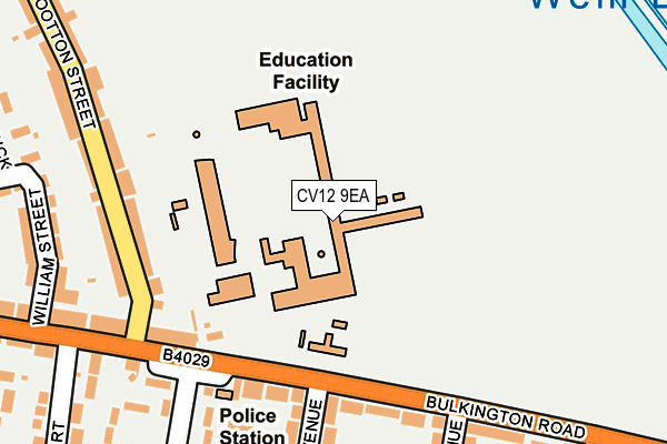
CV12 9EA is located in the Poplar electoral ward, within the local authority district of Nuneaton and Bedworth and the English Parliamentary constituency of North Warwickshire. The Sub Integrated Care Board (ICB) Location is NHS Coventry and Warwickshire ICB - B2M3M and the police force is Warwickshire. This postcode has been in use since January 1980.


GetTheData
Source: OS OpenMap – Local (Ordnance Survey)
Source: OS VectorMap District (Ordnance Survey)
Licence: Open Government Licence (requires attribution)
| Easting | 436782 |
| Northing | 287035 |
| Latitude | 52.480024 |
| Longitude | -1.459836 |
GetTheData
Source: Open Postcode Geo
Licence: Open Government Licence
| Country | England |
| Postcode District | CV12 |
➜ See where CV12 is on a map ➜ Where is Bedworth? | |
GetTheData
Source: Land Registry Price Paid Data
Licence: Open Government Licence
Elevation or altitude of CV12 9EA as distance above sea level:
| Metres | Feet | |
|---|---|---|
| Elevation | 100m | 328ft |
Elevation is measured from the approximate centre of the postcode, to the nearest point on an OS contour line from OS Terrain 50, which has contour spacing of ten vertical metres.
➜ How high above sea level am I? Find the elevation of your current position using your device's GPS.
GetTheData
Source: Open Postcode Elevation
Licence: Open Government Licence
| Ward | Poplar |
| Constituency | North Warwickshire |
GetTheData
Source: ONS Postcode Database
Licence: Open Government Licence
| York Avenue (Bulkington Road) | Bedworth | 161m |
| Nicholas Chamberlaine School (Wootton Street) | Bedworth | 193m |
| East Avenue (Bulkington Road) | Bedworth | 203m |
| Wootton Street (Bulkington Road) | Bedworth | 219m |
| Wootton Street (Bulkington Road) | Bedworth | 231m |
| Bedworth Station | 0.5km |
| Bermuda Park Station | 2.5km |
| Coventry Arena Station | 4.3km |
GetTheData
Source: NaPTAN
Licence: Open Government Licence
GetTheData
Source: ONS Postcode Database
Licence: Open Government Licence


➜ Get more ratings from the Food Standards Agency
GetTheData
Source: Food Standards Agency
Licence: FSA terms & conditions
| Last Collection | |||
|---|---|---|---|
| Location | Mon-Fri | Sat | Distance |
| Furnace Fields Post Office | 17:00 | 11:00 | 602m |
| Bedworth Delivery Office | 18:30 | 12:00 | 723m |
| Bedworth Delivery Office | 18:30 | 12:00 | 725m |
GetTheData
Source: Dracos
Licence: Creative Commons Attribution-ShareAlike
The below table lists the International Territorial Level (ITL) codes (formerly Nomenclature of Territorial Units for Statistics (NUTS) codes) and Local Administrative Units (LAU) codes for CV12 9EA:
| ITL 1 Code | Name |
|---|---|
| TLG | West Midlands (England) |
| ITL 2 Code | Name |
| TLG1 | Herefordshire, Worcestershire and Warwickshire |
| ITL 3 Code | Name |
| TLG13 | Warwickshire CC |
| LAU 1 Code | Name |
| E07000219 | Nuneaton and Bedworth |
GetTheData
Source: ONS Postcode Directory
Licence: Open Government Licence
The below table lists the Census Output Area (OA), Lower Layer Super Output Area (LSOA), and Middle Layer Super Output Area (MSOA) for CV12 9EA:
| Code | Name | |
|---|---|---|
| OA | E00158524 | |
| LSOA | E01031095 | Nuneaton and Bedworth 015A |
| MSOA | E02006489 | Nuneaton and Bedworth 015 |
GetTheData
Source: ONS Postcode Directory
Licence: Open Government Licence
| CV12 9DU | Wootton Street | 156m |
| CV12 9EB | Bulkington Road | 175m |
| CV12 9DX | Wootton Street | 180m |
| CV12 9ED | Bulkington Road | 202m |
| CV12 9EH | East Avenue | 244m |
| CV12 9DS | William Street | 247m |
| CV12 9DT | Bulkington Road | 249m |
| CV12 9DR | Bulkington Road | 256m |
| CV12 9DP | Brick Kiln Way | 282m |
| CV12 9EJ | York Avenue | 300m |
GetTheData
Source: Open Postcode Geo; Land Registry Price Paid Data
Licence: Open Government Licence