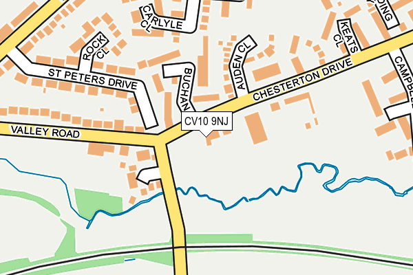
CV10 9NJ is located in the Galley Common electoral ward, within the local authority district of Nuneaton and Bedworth and the English Parliamentary constituency of Nuneaton. The Sub Integrated Care Board (ICB) Location is NHS Coventry and Warwickshire ICB - B2M3M and the police force is Warwickshire. This postcode has been in use since January 1980.


GetTheData
Source: OS OpenMap – Local (Ordnance Survey)
Source: OS VectorMap District (Ordnance Survey)
Licence: Open Government Licence (requires attribution)
| Easting | 431840 |
| Northing | 291850 |
| Latitude | 52.523618 |
| Longitude | -1.532141 |
GetTheData
Source: Open Postcode Geo
Licence: Open Government Licence
| Country | England |
| Postcode District | CV10 |
➜ See where CV10 is on a map ➜ Where is Nuneaton? | |
GetTheData
Source: Land Registry Price Paid Data
Licence: Open Government Licence
Elevation or altitude of CV10 9NJ as distance above sea level:
| Metres | Feet | |
|---|---|---|
| Elevation | 120m | 394ft |
Elevation is measured from the approximate centre of the postcode, to the nearest point on an OS contour line from OS Terrain 50, which has contour spacing of ten vertical metres.
➜ How high above sea level am I? Find the elevation of your current position using your device's GPS.
GetTheData
Source: Open Postcode Elevation
Licence: Open Government Licence
| Ward | Galley Common |
| Constituency | Nuneaton |
GetTheData
Source: ONS Postcode Database
Licence: Open Government Licence
| Arthur Rank Hall (Chesterton Drive) | Galley Common | 103m |
| Arthur Rank Hall (Chesterton Drive) | Galley Common | 117m |
| Valley Road | Galley Common | 162m |
| Valley Road | Galley Common | 172m |
| St Peters Drive (Hickman Road) | Galley Common | 289m |
| Nuneaton Station | 4.6km |
| Bermuda Park Station | 4.8km |
| Bedworth Station | 6.6km |
GetTheData
Source: NaPTAN
Licence: Open Government Licence
GetTheData
Source: ONS Postcode Database
Licence: Open Government Licence


➜ Get more ratings from the Food Standards Agency
GetTheData
Source: Food Standards Agency
Licence: FSA terms & conditions
| Last Collection | |||
|---|---|---|---|
| Location | Mon-Fri | Sat | Distance |
| Galley Common Post Office | 16:15 | 10:30 | 380m |
| School Hill | 16:45 | 11:45 | 1,630m |
| Ansley Buildings | 16:00 | 11:45 | 1,730m |
GetTheData
Source: Dracos
Licence: Creative Commons Attribution-ShareAlike
The below table lists the International Territorial Level (ITL) codes (formerly Nomenclature of Territorial Units for Statistics (NUTS) codes) and Local Administrative Units (LAU) codes for CV10 9NJ:
| ITL 1 Code | Name |
|---|---|
| TLG | West Midlands (England) |
| ITL 2 Code | Name |
| TLG1 | Herefordshire, Worcestershire and Warwickshire |
| ITL 3 Code | Name |
| TLG13 | Warwickshire CC |
| LAU 1 Code | Name |
| E07000219 | Nuneaton and Bedworth |
GetTheData
Source: ONS Postcode Directory
Licence: Open Government Licence
The below table lists the Census Output Area (OA), Lower Layer Super Output Area (LSOA), and Middle Layer Super Output Area (MSOA) for CV10 9NJ:
| Code | Name | |
|---|---|---|
| OA | E00158465 | |
| LSOA | E01031083 | Nuneaton and Bedworth 004C |
| MSOA | E02006478 | Nuneaton and Bedworth 004 |
GetTheData
Source: ONS Postcode Directory
Licence: Open Government Licence
| CV10 9RR | Buchan Close | 99m |
| CV10 9RP | Auden Close | 120m |
| CV10 8RP | Mayfair Drive | 123m |
| CV10 9RW | Wells Close | 171m |
| CV10 9NF | Rock Close | 194m |
| CV10 9NE | St Peters Drive | 195m |
| CV10 9QX | Carlyle Close | 196m |
| CV10 9NH | Valley Road | 226m |
| CV10 9RA | Bronte Close | 229m |
| CV10 9RG | Keats Close | 237m |
GetTheData
Source: Open Postcode Geo; Land Registry Price Paid Data
Licence: Open Government Licence