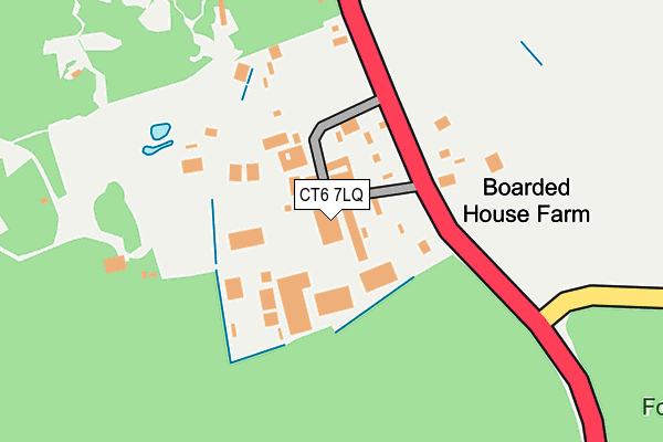
CT6 7LQ lies on West Blean House in Herne Bay. CT6 7LQ is located in the Sturry electoral ward, within the local authority district of Canterbury and the English Parliamentary constituency of Canterbury. The Sub Integrated Care Board (ICB) Location is NHS Kent and Medway ICB - 91Q and the police force is Kent. This postcode has been in use since August 1993.


GetTheData
Source: OS OpenMap – Local (Ordnance Survey)
Source: OS VectorMap District (Ordnance Survey)
Licence: Open Government Licence (requires attribution)
| Easting | 617383 |
| Northing | 163766 |
| Latitude | 51.331423 |
| Longitude | 1.119136 |
GetTheData
Source: Open Postcode Geo
Licence: Open Government Licence
| Street | West Blean House |
| Town/City | Herne Bay |
| Country | England |
| Postcode District | CT6 |
➜ See where CT6 is on a map | |
GetTheData
Source: Land Registry Price Paid Data
Licence: Open Government Licence
Elevation or altitude of CT6 7LQ as distance above sea level:
| Metres | Feet | |
|---|---|---|
| Elevation | 50m | 164ft |
Elevation is measured from the approximate centre of the postcode, to the nearest point on an OS contour line from OS Terrain 50, which has contour spacing of ten vertical metres.
➜ How high above sea level am I? Find the elevation of your current position using your device's GPS.
GetTheData
Source: Open Postcode Elevation
Licence: Open Government Licence
| Ward | Sturry |
| Constituency | Canterbury |
GetTheData
Source: ONS Postcode Database
Licence: Open Government Licence
| Wildwood (Canterbury Road) | Herne Common | 70m |
| Wildwood (Canterbury Road) | Herne Common | 83m |
| The Birches (Canterbury Road) | Herne Common | 536m |
| The Birches (Canterbury Road) | Herne Common | 560m |
| Punch Tavern (Herne Bay Road) | Calcott | 750m |
| Sturry Station | 3.4km |
| Herne Bay Station | 3.7km |
| Chestfield & Swalecliffe Station | 4.8km |
GetTheData
Source: NaPTAN
Licence: Open Government Licence
| Median download speed | 8.0Mbps |
| Average download speed | 10.3Mbps |
| Maximum download speed | 16.59Mbps |
| Median upload speed | 2.7Mbps |
| Average upload speed | 2.5Mbps |
| Maximum upload speed | 3.83Mbps |
GetTheData
Source: Ofcom
Licence: Ofcom Terms of Use (requires attribution)
GetTheData
Source: ONS Postcode Database
Licence: Open Government Licence


➜ Get more ratings from the Food Standards Agency
GetTheData
Source: Food Standards Agency
Licence: FSA terms & conditions
| Last Collection | |||
|---|---|---|---|
| Location | Mon-Fri | Sat | Distance |
| Herne Common | 17:30 | 11:30 | 70m |
| Hicks Forstal | 16:30 | 10:45 | 718m |
| Calcott | 16:30 | 11:00 | 786m |
GetTheData
Source: Dracos
Licence: Creative Commons Attribution-ShareAlike
The below table lists the International Territorial Level (ITL) codes (formerly Nomenclature of Territorial Units for Statistics (NUTS) codes) and Local Administrative Units (LAU) codes for CT6 7LQ:
| ITL 1 Code | Name |
|---|---|
| TLJ | South East (England) |
| ITL 2 Code | Name |
| TLJ4 | Kent |
| ITL 3 Code | Name |
| TLJ44 | East Kent |
| LAU 1 Code | Name |
| E07000106 | Canterbury |
GetTheData
Source: ONS Postcode Directory
Licence: Open Government Licence
The below table lists the Census Output Area (OA), Lower Layer Super Output Area (LSOA), and Middle Layer Super Output Area (MSOA) for CT6 7LQ:
| Code | Name | |
|---|---|---|
| OA | E00122403 | |
| LSOA | E01024110 | Canterbury 011B |
| MSOA | E02005020 | Canterbury 011 |
GetTheData
Source: ONS Postcode Directory
Licence: Open Government Licence
| CT6 7LG | Herne Common | 40m |
| CT6 7LE | Canterbury Road | 703m |
| CT3 4NB | Calcott | 718m |
| CT3 4NA | Hicks Forstal Road | 733m |
| CT3 4ER | Farthings Wood Rise | 901m |
| CT6 7NP | Braggs Lane | 1009m |
| CT3 4ND | Calcott Hill | 1110m |
| CT6 7NW | Bullockstone Road | 1190m |
| CT6 7LJ | Busheyfields Road | 1206m |
| CT6 7LB | Herne Common | 1250m |
GetTheData
Source: Open Postcode Geo; Land Registry Price Paid Data
Licence: Open Government Licence