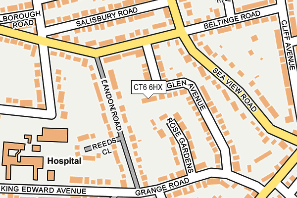
CT6 6HX lies on Ashburn Gardens in Herne Bay. CT6 6HX is located in the Beltinge electoral ward, within the local authority district of Canterbury and the English Parliamentary constituency of North Thanet. The Sub Integrated Care Board (ICB) Location is NHS Kent and Medway ICB - 91Q and the police force is Kent. This postcode has been in use since January 1980.


GetTheData
Source: OS OpenMap – Local (Ordnance Survey)
Source: OS VectorMap District (Ordnance Survey)
Licence: Open Government Licence (requires attribution)
| Easting | 619122 |
| Northing | 168019 |
| Latitude | 51.368935 |
| Longitude | 1.146646 |
GetTheData
Source: Open Postcode Geo
Licence: Open Government Licence
| Street | Ashburn Gardens |
| Town/City | Herne Bay |
| Country | England |
| Postcode District | CT6 |
➜ See where CT6 is on a map ➜ Where is Herne Bay? | |
GetTheData
Source: Land Registry Price Paid Data
Licence: Open Government Licence
Elevation or altitude of CT6 6HX as distance above sea level:
| Metres | Feet | |
|---|---|---|
| Elevation | 30m | 98ft |
Elevation is measured from the approximate centre of the postcode, to the nearest point on an OS contour line from OS Terrain 50, which has contour spacing of ten vertical metres.
➜ How high above sea level am I? Find the elevation of your current position using your device's GPS.
GetTheData
Source: Open Postcode Elevation
Licence: Open Government Licence
| Ward | Beltinge |
| Constituency | North Thanet |
GetTheData
Source: ONS Postcode Database
Licence: Open Government Licence
| Glen Avenue (Beltinge Road) | Herne Bay | 99m |
| Glen Avenue (Beltinge Road) | Herne Bay | 129m |
| Landon Road (Grange Road) | Herne Bay | 180m |
| Landon Road (King Edward Avenue) | Herne Bay | 214m |
| Hilary Close (Grange Road) | Beltinge | 220m |
| Herne Bay Station | 2.1km |
GetTheData
Source: NaPTAN
Licence: Open Government Licence
| Percentage of properties with Next Generation Access | 100.0% |
| Percentage of properties with Superfast Broadband | 100.0% |
| Percentage of properties with Ultrafast Broadband | 0.0% |
| Percentage of properties with Full Fibre Broadband | 0.0% |
Superfast Broadband is between 30Mbps and 300Mbps
Ultrafast Broadband is > 300Mbps
| Percentage of properties unable to receive 2Mbps | 0.0% |
| Percentage of properties unable to receive 5Mbps | 0.0% |
| Percentage of properties unable to receive 10Mbps | 0.0% |
| Percentage of properties unable to receive 30Mbps | 0.0% |
GetTheData
Source: Ofcom
Licence: Ofcom Terms of Use (requires attribution)
GetTheData
Source: ONS Postcode Database
Licence: Open Government Licence


➜ Get more ratings from the Food Standards Agency
GetTheData
Source: Food Standards Agency
Licence: FSA terms & conditions
| Last Collection | |||
|---|---|---|---|
| Location | Mon-Fri | Sat | Distance |
| Seaview Road | 16:00 | 10:45 | 151m |
| Highfield Avenue Estate | 17:00 | 10:45 | 320m |
| Dence Park | 16:00 | 11:00 | 427m |
GetTheData
Source: Dracos
Licence: Creative Commons Attribution-ShareAlike
The below table lists the International Territorial Level (ITL) codes (formerly Nomenclature of Territorial Units for Statistics (NUTS) codes) and Local Administrative Units (LAU) codes for CT6 6HX:
| ITL 1 Code | Name |
|---|---|
| TLJ | South East (England) |
| ITL 2 Code | Name |
| TLJ4 | Kent |
| ITL 3 Code | Name |
| TLJ44 | East Kent |
| LAU 1 Code | Name |
| E07000106 | Canterbury |
GetTheData
Source: ONS Postcode Directory
Licence: Open Government Licence
The below table lists the Census Output Area (OA), Lower Layer Super Output Area (LSOA), and Middle Layer Super Output Area (MSOA) for CT6 6HX:
| Code | Name | |
|---|---|---|
| OA | E00122335 | |
| LSOA | E01024097 | Canterbury 002C |
| MSOA | E02005011 | Canterbury 002 |
GetTheData
Source: ONS Postcode Directory
Licence: Open Government Licence
| CT6 6HU | Glen Avenue | 84m |
| CT6 6NJ | Rose Gardens | 92m |
| CT6 6HP | Landon Road | 99m |
| CT6 6HT | Beltinge Road | 105m |
| CT6 6HY | Glen Avenue | 121m |
| CT6 6HS | Beltinge Road | 138m |
| CT6 6NQ | Grange Road | 163m |
| CT6 6JA | Sea View Road | 170m |
| CT6 6HR | Reeds Close | 176m |
| CT6 6HH | Beacon Avenue | 185m |
GetTheData
Source: Open Postcode Geo; Land Registry Price Paid Data
Licence: Open Government Licence