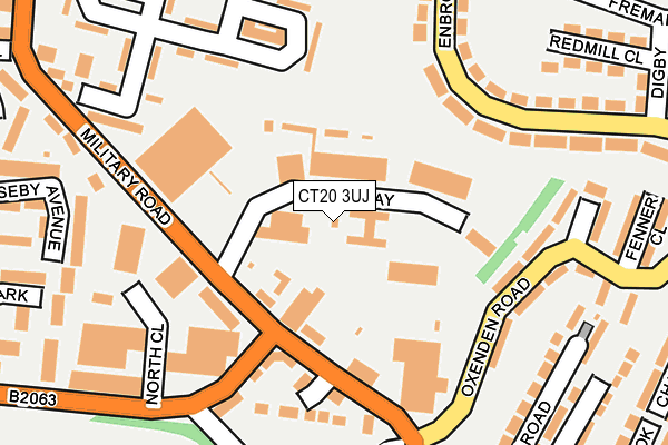
CT20 3UJ lies on Ross Way in Folkestone. CT20 3UJ is located in the Sandgate & West Folkestone electoral ward, within the local authority district of Folkestone and Hythe and the English Parliamentary constituency of Folkestone and Hythe. The Sub Integrated Care Board (ICB) Location is NHS Kent and Medway ICB - 91Q and the police force is Kent. This postcode has been in use since January 1980.


GetTheData
Source: OS OpenMap – Local (Ordnance Survey)
Source: OS VectorMap District (Ordnance Survey)
Licence: Open Government Licence (requires attribution)
| Easting | 620132 |
| Northing | 135997 |
| Latitude | 51.081046 |
| Longitude | 1.141514 |
GetTheData
Source: Open Postcode Geo
Licence: Open Government Licence
| Street | Ross Way |
| Town/City | Folkestone |
| Country | England |
| Postcode District | CT20 |
➜ See where CT20 is on a map ➜ Where is Folkestone? | |
GetTheData
Source: Land Registry Price Paid Data
Licence: Open Government Licence
Elevation or altitude of CT20 3UJ as distance above sea level:
| Metres | Feet | |
|---|---|---|
| Elevation | 60m | 197ft |
Elevation is measured from the approximate centre of the postcode, to the nearest point on an OS contour line from OS Terrain 50, which has contour spacing of ten vertical metres.
➜ How high above sea level am I? Find the elevation of your current position using your device's GPS.
GetTheData
Source: Open Postcode Elevation
Licence: Open Government Licence
| Ward | Sandgate & West Folkestone |
| Constituency | Folkestone And Hythe |
GetTheData
Source: ONS Postcode Database
Licence: Open Government Licence
| Ross Way (Military Road) | Shorncliffe | 154m |
| Fenner Close (Oxenden Road) | Shorncliffe | 206m |
| Enbrook Valley Fremantle Road (Enbrook Valley) | Shorncliffe | 217m |
| Fenner Close (Oxenden Road) | Shorncliffe | 219m |
| Enbrook Valley Fremantle Road (Enbrook Valley) | Shorncliffe | 240m |
| Folkestone West Station | 1km |
| Folkestone Central Station | 2km |
GetTheData
Source: NaPTAN
Licence: Open Government Licence
| Percentage of properties with Next Generation Access | 100.0% |
| Percentage of properties with Superfast Broadband | 100.0% |
| Percentage of properties with Ultrafast Broadband | 100.0% |
| Percentage of properties with Full Fibre Broadband | 0.0% |
Superfast Broadband is between 30Mbps and 300Mbps
Ultrafast Broadband is > 300Mbps
| Median download speed | 32.0Mbps |
| Average download speed | 31.4Mbps |
| Maximum download speed | 79.98Mbps |
| Median upload speed | 6.2Mbps |
| Average upload speed | 6.6Mbps |
| Maximum upload speed | 20.00Mbps |
| Percentage of properties unable to receive 2Mbps | 0.0% |
| Percentage of properties unable to receive 5Mbps | 0.0% |
| Percentage of properties unable to receive 10Mbps | 0.0% |
| Percentage of properties unable to receive 30Mbps | 0.0% |
GetTheData
Source: Ofcom
Licence: Ofcom Terms of Use (requires attribution)
GetTheData
Source: ONS Postcode Database
Licence: Open Government Licence


➜ Get more ratings from the Food Standards Agency
GetTheData
Source: Food Standards Agency
Licence: FSA terms & conditions
| Last Collection | |||
|---|---|---|---|
| Location | Mon-Fri | Sat | Distance |
| Mckenzie Drive | 17:30 | 12:00 | 194m |
| Chichester Road | 17:45 | 12:00 | 280m |
| Shorncliffe Post Office | 17:30 | 12:00 | 456m |
GetTheData
Source: Dracos
Licence: Creative Commons Attribution-ShareAlike
The below table lists the International Territorial Level (ITL) codes (formerly Nomenclature of Territorial Units for Statistics (NUTS) codes) and Local Administrative Units (LAU) codes for CT20 3UJ:
| ITL 1 Code | Name |
|---|---|
| TLJ | South East (England) |
| ITL 2 Code | Name |
| TLJ4 | Kent |
| ITL 3 Code | Name |
| TLJ44 | East Kent |
| LAU 1 Code | Name |
| E07000112 | Folkestone and Hythe |
GetTheData
Source: ONS Postcode Directory
Licence: Open Government Licence
The below table lists the Census Output Area (OA), Lower Layer Super Output Area (LSOA), and Middle Layer Super Output Area (MSOA) for CT20 3UJ:
| Code | Name | |
|---|---|---|
| OA | E00124457 | |
| LSOA | E01024519 | Shepway 006G |
| MSOA | E02005107 | Shepway 006 |
GetTheData
Source: ONS Postcode Directory
Licence: Open Government Licence
| CT20 3NJ | Oxenden Road | 159m |
| CT20 3NA | Enbrook Valley | 191m |
| CT20 3BS | Valley Road | 209m |
| CT20 3NL | Vincent Close | 209m |
| CT20 3NH | Fenner Close | 225m |
| CT20 3UH | Shornecliffe Industrial Estate | 232m |
| CT20 3LS | Craufurd Green | 269m |
| CT20 3BP | Chichester Road | 271m |
| CT20 3NG | Chalcroft Road | 291m |
| CT20 3BT | Valley Road | 292m |
GetTheData
Source: Open Postcode Geo; Land Registry Price Paid Data
Licence: Open Government Licence