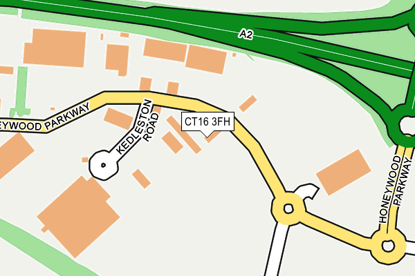
CT16 3FH lies on The Glenmore Centre in Whitfield, Dover. CT16 3FH is located in the Whitfield electoral ward, within the local authority district of Dover and the English Parliamentary constituency of Dover. The Sub Integrated Care Board (ICB) Location is NHS Kent and Medway ICB - 91Q and the police force is Kent. This postcode has been in use since July 2008.


GetTheData
Source: OS OpenMap – Local (Ordnance Survey)
Source: OS VectorMap District (Ordnance Survey)
Licence: Open Government Licence (requires attribution)
| Easting | 631170 |
| Northing | 144476 |
| Latitude | 51.152829 |
| Longitude | 1.304261 |
GetTheData
Source: Open Postcode Geo
Licence: Open Government Licence
| Street | The Glenmore Centre |
| Locality | Whitfield |
| Town/City | Dover |
| Country | England |
| Postcode District | CT16 |
➜ See where CT16 is on a map ➜ Where is Whitfield? | |
GetTheData
Source: Land Registry Price Paid Data
Licence: Open Government Licence
Elevation or altitude of CT16 3FH as distance above sea level:
| Metres | Feet | |
|---|---|---|
| Elevation | 120m | 394ft |
Elevation is measured from the approximate centre of the postcode, to the nearest point on an OS contour line from OS Terrain 50, which has contour spacing of ten vertical metres.
➜ How high above sea level am I? Find the elevation of your current position using your device's GPS.
GetTheData
Source: Open Postcode Elevation
Licence: Open Government Licence
| Ward | Whitfield |
| Constituency | Dover |
GetTheData
Source: ONS Postcode Database
Licence: Open Government Licence
| B And Q (Honeywood Parkway) | Whitfield | 209m |
| B And Q (Honeywood Parkway) | Whitfield | 239m |
| Homebase (Honeywood Parkway) | Whitfield | 271m |
| Homebase (Honeywood Parkway) | Whitfield | 309m |
| B And Q Store (B And Q Car Park) | Whitfield | 385m |
| Kearsney Station | 2.3km |
| Dover Priory Station | 3km |
| Martin Mill Station | 3.7km |
GetTheData
Source: NaPTAN
Licence: Open Government Licence
| Median download speed | 19.3Mbps |
| Average download speed | 18.8Mbps |
| Maximum download speed | 23.06Mbps |
| Median upload speed | 1.2Mbps |
| Average upload speed | 1.2Mbps |
| Maximum upload speed | 1.25Mbps |
GetTheData
Source: Ofcom
Licence: Ofcom Terms of Use (requires attribution)
GetTheData
Source: ONS Postcode Database
Licence: Open Government Licence


➜ Get more ratings from the Food Standards Agency
GetTheData
Source: Food Standards Agency
Licence: FSA terms & conditions
| Last Collection | |||
|---|---|---|---|
| Location | Mon-Fri | Sat | Distance |
| Tesco | 17:00 | 11:45 | 404m |
| Rokesley Road | 18:00 | 11:45 | 583m |
| Cranleigh Drive | 17:15 | 09:00 | 846m |
GetTheData
Source: Dracos
Licence: Creative Commons Attribution-ShareAlike
The below table lists the International Territorial Level (ITL) codes (formerly Nomenclature of Territorial Units for Statistics (NUTS) codes) and Local Administrative Units (LAU) codes for CT16 3FH:
| ITL 1 Code | Name |
|---|---|
| TLJ | South East (England) |
| ITL 2 Code | Name |
| TLJ4 | Kent |
| ITL 3 Code | Name |
| TLJ44 | East Kent |
| LAU 1 Code | Name |
| E07000108 | Dover |
GetTheData
Source: ONS Postcode Directory
Licence: Open Government Licence
The below table lists the Census Output Area (OA), Lower Layer Super Output Area (LSOA), and Middle Layer Super Output Area (MSOA) for CT16 3FH:
| Code | Name | |
|---|---|---|
| OA | E00171558 | |
| LSOA | E01024254 | Dover 010E |
| MSOA | E02005050 | Dover 010 |
GetTheData
Source: ONS Postcode Directory
Licence: Open Government Licence
| CT16 3PT | Honeywood Parkway | 92m |
| CT16 2ER | Colton Crescent | 533m |
| CT16 2EB | Melbourne Avenue | 552m |
| CT16 2EQ | Rokesley Road | 552m |
| CT16 2EE | Fulbert Road | 574m |
| CT16 2ED | Fulbert Road | 595m |
| CT16 2EZ | Whyte Close | 618m |
| CT16 2JH | Melbourne Avenue | 618m |
| CT16 2EW | Peverell Road | 634m |
| CT16 2EP | Colton Crescent | 640m |
GetTheData
Source: Open Postcode Geo; Land Registry Price Paid Data
Licence: Open Government Licence