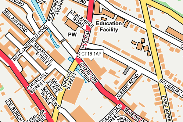
CT16 1AP is located in the St Radigunds electoral ward, within the local authority district of Dover and the English Parliamentary constituency of Dover. The Sub Integrated Care Board (ICB) Location is NHS Kent and Medway ICB - 91Q and the police force is Kent. This postcode has been in use since March 2022.


GetTheData
Source: OS OpenMap – Local (Ordnance Survey)
Source: OS VectorMap District (Ordnance Survey)
Licence: Open Government Licence (requires attribution)
| Easting | 631464 |
| Northing | 142186 |
| Latitude | 51.132153 |
| Longitude | 1.306987 |
GetTheData
Source: Open Postcode Geo
Licence: Open Government Licence
| Country | England |
| Postcode District | CT16 |
➜ See where CT16 is on a map ➜ Where is Dover? | |
GetTheData
Source: Land Registry Price Paid Data
Licence: Open Government Licence
Elevation or altitude of CT16 1AP as distance above sea level:
| Metres | Feet | |
|---|---|---|
| Elevation | 10m | 33ft |
Elevation is measured from the approximate centre of the postcode, to the nearest point on an OS contour line from OS Terrain 50, which has contour spacing of ten vertical metres.
➜ How high above sea level am I? Find the elevation of your current position using your device's GPS.
GetTheData
Source: Open Postcode Elevation
Licence: Open Government Licence
| Ward | St Radigunds |
| Constituency | Dover |
GetTheData
Source: ONS Postcode Database
Licence: Open Government Licence
| Dover Girls' Grammar School (Frith Road) | Dover | 118m |
| Templar Street (London Road) | Dover | 227m |
| Five Ways (Maison Dieu Road) | Dover | 238m |
| Park Avenue | Dover | 239m |
| Charlton Primary School (Barton Road) | Dover | 283m |
| Dover Priory Station | 0.7km |
| Kearsney Station | 3.1km |
| Martin Mill Station | 5.2km |
GetTheData
Source: NaPTAN
Licence: Open Government Licence
GetTheData
Source: ONS Postcode Database
Licence: Open Government Licence


➜ Get more ratings from the Food Standards Agency
GetTheData
Source: Food Standards Agency
Licence: FSA terms & conditions
| Last Collection | |||
|---|---|---|---|
| Location | Mon-Fri | Sat | Distance |
| Granville Street Post Office | 18:30 | 12:45 | 158m |
| Frith Road | 18:30 | 11:30 | 188m |
| Branch Street | 18:30 | 12:15 | 195m |
GetTheData
Source: Dracos
Licence: Creative Commons Attribution-ShareAlike
The below table lists the International Territorial Level (ITL) codes (formerly Nomenclature of Territorial Units for Statistics (NUTS) codes) and Local Administrative Units (LAU) codes for CT16 1AP:
| ITL 1 Code | Name |
|---|---|
| TLJ | South East (England) |
| ITL 2 Code | Name |
| TLJ4 | Kent |
| ITL 3 Code | Name |
| TLJ44 | East Kent |
| LAU 1 Code | Name |
| E07000108 | Dover |
GetTheData
Source: ONS Postcode Directory
Licence: Open Government Licence
The below table lists the Census Output Area (OA), Lower Layer Super Output Area (LSOA), and Middle Layer Super Output Area (MSOA) for CT16 1AP:
| Code | Name | |
|---|---|---|
| OA | E00123104 | |
| LSOA | E01024247 | Dover 012D |
| MSOA | E02005052 | Dover 012 |
GetTheData
Source: ONS Postcode Directory
Licence: Open Government Licence
| CT16 1EU | Salisbury Road | 78m |
| CT16 2PY | Frith Road | 94m |
| CT16 1RA | Maison Dieu Road | 112m |
| CT16 1EX | Salisbury Road | 112m |
| CT16 2LG | Granville Street | 115m |
| CT16 2PS | Charlton Green | 118m |
| CT16 2LB | Bridge Street | 120m |
| CT16 1RB | Maison Dieu Road | 137m |
| CT16 2LD | Pauls Place | 156m |
| CT16 1RD | Albert Road | 157m |
GetTheData
Source: Open Postcode Geo; Land Registry Price Paid Data
Licence: Open Government Licence