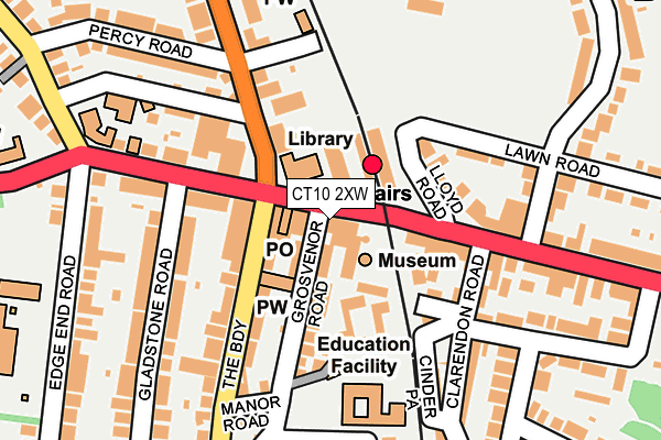
CT10 2XW is located in the Viking electoral ward, within the local authority district of Thanet and the English Parliamentary constituency of South Thanet. The Sub Integrated Care Board (ICB) Location is NHS Kent and Medway ICB - 91Q and the police force is Kent. This postcode has been in use since February 2019.


GetTheData
Source: OS OpenMap – Local (Ordnance Survey)
Source: OS VectorMap District (Ordnance Survey)
Licence: Open Government Licence (requires attribution)
| Easting | 639084 |
| Northing | 167941 |
| Latitude | 51.360197 |
| Longitude | 1.432875 |
GetTheData
Source: Open Postcode Geo
Licence: Open Government Licence
| Country | England |
| Postcode District | CT10 |
➜ See where CT10 is on a map ➜ Where is Broadstairs? | |
GetTheData
Source: Land Registry Price Paid Data
Licence: Open Government Licence
Elevation or altitude of CT10 2XW as distance above sea level:
| Metres | Feet | |
|---|---|---|
| Elevation | 40m | 131ft |
Elevation is measured from the approximate centre of the postcode, to the nearest point on an OS contour line from OS Terrain 50, which has contour spacing of ten vertical metres.
➜ How high above sea level am I? Find the elevation of your current position using your device's GPS.
GetTheData
Source: Open Postcode Elevation
Licence: Open Government Licence
| Ward | Viking |
| Constituency | South Thanet |
GetTheData
Source: ONS Postcode Database
Licence: Open Government Licence
| Railway Station (Lloyd Road) | Broadstairs | 71m |
| Osbourne Road (The Broadway) | Broadstairs | 97m |
| Railway Station (High Street) | Broadstairs | 120m |
| Percy Road (St Peter's Park Road) | Broadstairs | 126m |
| Railway Station (High Street) | Broadstairs | 138m |
| Broadstairs Station | 0.1km |
| Dumpton Park Station | 1.7km |
| Ramsgate Station | 2.8km |
GetTheData
Source: NaPTAN
Licence: Open Government Licence
GetTheData
Source: ONS Postcode Database
Licence: Open Government Licence


➜ Get more ratings from the Food Standards Agency
GetTheData
Source: Food Standards Agency
Licence: FSA terms & conditions
| Last Collection | |||
|---|---|---|---|
| Location | Mon-Fri | Sat | Distance |
| Broadstairs Post Office | 17:30 | 12:30 | 50m |
| Pierremont Avenue | 17:30 | 11:45 | 220m |
| Gladstone Road | 16:00 | 11:30 | 275m |
GetTheData
Source: Dracos
Licence: Creative Commons Attribution-ShareAlike
The below table lists the International Territorial Level (ITL) codes (formerly Nomenclature of Territorial Units for Statistics (NUTS) codes) and Local Administrative Units (LAU) codes for CT10 2XW:
| ITL 1 Code | Name |
|---|---|
| TLJ | South East (England) |
| ITL 2 Code | Name |
| TLJ4 | Kent |
| ITL 3 Code | Name |
| TLJ44 | East Kent |
| LAU 1 Code | Name |
| E07000114 | Thanet |
GetTheData
Source: ONS Postcode Directory
Licence: Open Government Licence
The below table lists the Census Output Area (OA), Lower Layer Super Output Area (LSOA), and Middle Layer Super Output Area (MSOA) for CT10 2XW:
| Code | Name | |
|---|---|---|
| OA | E00125421 | |
| LSOA | E01024706 | Thanet 010C |
| MSOA | E02005141 | Thanet 010 |
GetTheData
Source: ONS Postcode Directory
Licence: Open Government Licence
| CT10 2AD | The Broadway | 55m |
| CT10 2BT | Grosvenor Road | 82m |
| CT10 2XU | Grosvenor Road | 101m |
| CT10 1HZ | Lloyd Road | 105m |
| CT10 1NG | High Street | 109m |
| CT10 1RZ | Clarendon Mews | 117m |
| CT10 2AG | St Peters Road | 124m |
| CT10 2BL | St Peters Park Road | 132m |
| CT10 2AE | Osborne Road | 143m |
| CT10 1NW | Clarendon Road | 144m |
GetTheData
Source: Open Postcode Geo; Land Registry Price Paid Data
Licence: Open Government Licence