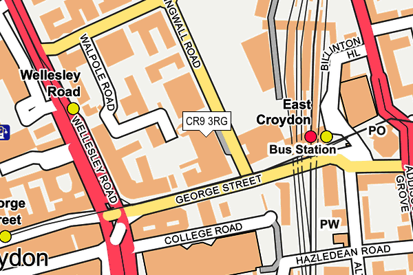
CR9 3RG is located in the Fairfield electoral ward, within the London borough of Croydon and the English Parliamentary constituency of Croydon Central. The Sub Integrated Care Board (ICB) Location is NHS South West London ICB - 36L and the police force is Metropolitan Police. This postcode has been in use since January 1980.


GetTheData
Source: OS OpenMap – Local (Ordnance Survey)
Source: OS VectorMap District (Ordnance Survey)
Licence: Open Government Licence (requires attribution)
| Easting | 532700 |
| Northing | 165728 |
| Latitude | 51.375108 |
| Longitude | -0.094820 |
GetTheData
Source: Open Postcode Geo
Licence: Open Government Licence
| Country | England |
| Postcode District | CR9 |
➜ Where is Croydon? | |
GetTheData
Source: Land Registry Price Paid Data
Licence: Open Government Licence
Elevation or altitude of CR9 3RG as distance above sea level:
| Metres | Feet | |
|---|---|---|
| Elevation | 60m | 197ft |
Elevation is measured from the approximate centre of the postcode, to the nearest point on an OS contour line from OS Terrain 50, which has contour spacing of ten vertical metres.
➜ How high above sea level am I? Find the elevation of your current position using your device's GPS.
GetTheData
Source: Open Postcode Elevation
Licence: Open Government Licence
| Ward | Fairfield |
| Constituency | Croydon Central |
GetTheData
Source: ONS Postcode Database
Licence: Open Government Licence
| East Croydon Rail Station | Croydon | 23m |
| East Croydon Rail Station | Croydon | 35m |
| Dingwall Road | Croydon | 42m |
| East Croydon Rail Station | Croydon | 122m |
| East Croydon Rail Station (George Street) | Croydon | 159m |
| East Croydon Tram Stop (George Street) | Croydon | 170m |
| Wellesley Road Tram Stop (Wellesley Road) | Croydon | 193m |
| George Street Tram Stop (George Street) | Croydon | 301m |
| Centrale Tram Stop (Tamworth Road) | Croydon | 638m |
| West Croydon Tram Stop (Station Road) | Croydon | 643m |
| East Croydon Station | 0.1km |
| West Croydon Station | 0.7km |
| South Croydon Station | 1.4km |
GetTheData
Source: NaPTAN
Licence: Open Government Licence
GetTheData
Source: ONS Postcode Database
Licence: Open Government Licence


➜ Get more ratings from the Food Standards Agency
GetTheData
Source: Food Standards Agency
Licence: FSA terms & conditions
| Last Collection | |||
|---|---|---|---|
| Location | Mon-Fri | Sat | Distance |
| Wellesley Court Road (2) | 17:45 | 12:00 | 157m |
| Lansdown Road | 17:30 | 12:00 | 213m |
| Dingwall Avenue (Opp 2) | 18:15 | 12:00 | 215m |
GetTheData
Source: Dracos
Licence: Creative Commons Attribution-ShareAlike
The below table lists the International Territorial Level (ITL) codes (formerly Nomenclature of Territorial Units for Statistics (NUTS) codes) and Local Administrative Units (LAU) codes for CR9 3RG:
| ITL 1 Code | Name |
|---|---|
| TLI | London |
| ITL 2 Code | Name |
| TLI6 | Outer London - South |
| ITL 3 Code | Name |
| TLI62 | Croydon |
| LAU 1 Code | Name |
| E09000008 | Croydon |
GetTheData
Source: ONS Postcode Directory
Licence: Open Government Licence
The below table lists the Census Output Area (OA), Lower Layer Super Output Area (LSOA), and Middle Layer Super Output Area (MSOA) for CR9 3RG:
| Code | Name | |
|---|---|---|
| OA | E00005197 | |
| LSOA | E01001045 | Croydon 027C |
| MSOA | E02000220 | Croydon 027 |
GetTheData
Source: ONS Postcode Directory
Licence: Open Government Licence
| CR0 1LD | George Street | 34m |
| CR0 1PJ | George Street | 100m |
| CR0 1LE | Wellesley Court Road | 136m |
| CR0 5LA | Altyre Road | 228m |
| CR0 2BX | Lansdowne Road | 258m |
| CR9 6LL | Addiscombe Road | 258m |
| CR0 1YD | Park Street | 272m |
| CR0 5LE | Altyre Road | 288m |
| CR0 5LF | Altyre Road | 288m |
| CR0 5LR | Addiscombe Grove | 306m |
GetTheData
Source: Open Postcode Geo; Land Registry Price Paid Data
Licence: Open Government Licence