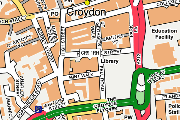
CR9 1RH is located in the Fairfield electoral ward, within the London borough of Croydon and the English Parliamentary constituency of Croydon Central. The Sub Integrated Care Board (ICB) Location is NHS South West London ICB - 36L and the police force is Metropolitan Police. This postcode has been in use since March 2006.


GetTheData
Source: OS OpenMap – Local (Ordnance Survey)
Source: OS VectorMap District (Ordnance Survey)
Licence: Open Government Licence (requires attribution)
| Easting | 532417 |
| Northing | 165393 |
| Latitude | 51.372163 |
| Longitude | -0.099008 |
GetTheData
Source: Open Postcode Geo
Licence: Open Government Licence
| Country | England |
| Postcode District | CR9 |
➜ Where is Croydon? | |
GetTheData
Source: Land Registry Price Paid Data
Licence: Open Government Licence
Elevation or altitude of CR9 1RH as distance above sea level:
| Metres | Feet | |
|---|---|---|
| Elevation | 50m | 164ft |
Elevation is measured from the approximate centre of the postcode, to the nearest point on an OS contour line from OS Terrain 50, which has contour spacing of ten vertical metres.
➜ How high above sea level am I? Find the elevation of your current position using your device's GPS.
GetTheData
Source: Open Postcode Elevation
Licence: Open Government Licence
| Ward | Fairfield |
| Constituency | Croydon Central |
GetTheData
Source: ONS Postcode Database
Licence: Open Government Licence
| Croydon Library (Katharine Street) | Croydon | 25m |
| Croydon Library (Katharine Street) | Croydon | 27m |
| Taberner House (Katharine Street) | Croydon | 67m |
| Croydon Library (Katharine Street) | Croydon | 70m |
| Croydon Flyover (Croydon High Street) | Croydon | 123m |
| George Street Tram Stop (George Street) | Croydon | 202m |
| Wellesley Road Tram Stop (Wellesley Road) | Croydon | 371m |
| Church Street Tram Stop (Church Street) | Croydon | 410m |
| Centrale Tram Stop (Tamworth Road) | Croydon | 527m |
| East Croydon Tram Stop (George Street) | Croydon | 548m |
| East Croydon Station | 0.6km |
| West Croydon Station | 0.7km |
| South Croydon Station | 1.1km |
GetTheData
Source: NaPTAN
Licence: Open Government Licence
GetTheData
Source: ONS Postcode Database
Licence: Open Government Licence


➜ Get more ratings from the Food Standards Agency
GetTheData
Source: Food Standards Agency
Licence: FSA terms & conditions
| Last Collection | |||
|---|---|---|---|
| Location | Mon-Fri | Sat | Distance |
| Katherine Street | 18:45 | 12:00 | 32m |
| Park Lane | 18:45 | 12:00 | 155m |
| 10 High Street P.o. | 18:45 | 12:15 | 168m |
GetTheData
Source: Dracos
Licence: Creative Commons Attribution-ShareAlike
The below table lists the International Territorial Level (ITL) codes (formerly Nomenclature of Territorial Units for Statistics (NUTS) codes) and Local Administrative Units (LAU) codes for CR9 1RH:
| ITL 1 Code | Name |
|---|---|
| TLI | London |
| ITL 2 Code | Name |
| TLI6 | Outer London - South |
| ITL 3 Code | Name |
| TLI62 | Croydon |
| LAU 1 Code | Name |
| E09000008 | Croydon |
GetTheData
Source: ONS Postcode Directory
Licence: Open Government Licence
The below table lists the Census Output Area (OA), Lower Layer Super Output Area (LSOA), and Middle Layer Super Output Area (MSOA) for CR9 1RH:
| Code | Name | |
|---|---|---|
| OA | E00005206 | |
| LSOA | E01001043 | Croydon 027B |
| MSOA | E02000220 | Croydon 027 |
GetTheData
Source: ONS Postcode Directory
Licence: Open Government Licence
| CR0 1XS | Mint Walk | 85m |
| CR0 1YB | High Street | 117m |
| CR0 1QB | High Street | 123m |
| CR0 1QE | High Street | 126m |
| CR0 1FN | Scarbrook Road | 142m |
| CR0 1NA | High Street | 163m |
| CR0 1UL | Waterworks Yard | 168m |
| CR0 1RJ | Surrey Street | 169m |
| CR0 1UH | Scarbrook Road | 170m |
| CR0 1YD | Park Street | 183m |
GetTheData
Source: Open Postcode Geo; Land Registry Price Paid Data
Licence: Open Government Licence