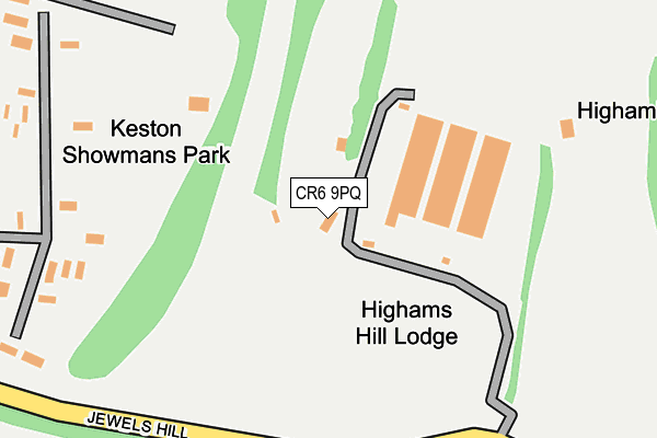
CR6 9PQ lies on Sheep Barn Lane in Warlingham. CR6 9PQ is located in the Darwin electoral ward, within the London borough of Bromley and the English Parliamentary constituency of Orpington. The Sub Integrated Care Board (ICB) Location is NHS South East London ICB - 72Q and the police force is Metropolitan Police. This postcode has been in use since July 1990.


GetTheData
Source: OS OpenMap – Local (Ordnance Survey)
Source: OS VectorMap District (Ordnance Survey)
Licence: Open Government Licence (requires attribution)
| Easting | 540111 |
| Northing | 161298 |
| Latitude | 51.333521 |
| Longitude | 0.009875 |
GetTheData
Source: Open Postcode Geo
Licence: Open Government Licence
| Street | Sheep Barn Lane |
| Town/City | Warlingham |
| Country | England |
| Postcode District | CR6 |
➜ See where CR6 is on a map | |
GetTheData
Source: Land Registry Price Paid Data
Licence: Open Government Licence
Elevation or altitude of CR6 9PQ as distance above sea level:
| Metres | Feet | |
|---|---|---|
| Elevation | 160m | 525ft |
Elevation is measured from the approximate centre of the postcode, to the nearest point on an OS contour line from OS Terrain 50, which has contour spacing of ten vertical metres.
➜ How high above sea level am I? Find the elevation of your current position using your device's GPS.
GetTheData
Source: Open Postcode Elevation
Licence: Open Government Licence
| Ward | Darwin |
| Constituency | Orpington |
GetTheData
Source: ONS Postcode Database
Licence: Open Government Licence
| Meridian High School (King Henry's Drive) | New Addington | 788m |
| Meridian High School (King Henry's Drive) | New Addington | 790m |
| King Henry's Drive Homestead Way (King Henry's Drive) | New Addington | 836m |
| King Henry's Drive Homestead Way (King Henry's Drive) | New Addington | 873m |
| Warbank Crescent (King Henry's Drive) | New Addington | 996m |
| Hayes (Kent) Station | 4.8km |
| Woldingham Station | 6.5km |
GetTheData
Source: NaPTAN
Licence: Open Government Licence
| Percentage of properties with Next Generation Access | 0.0% |
| Percentage of properties with Superfast Broadband | 0.0% |
| Percentage of properties with Ultrafast Broadband | 0.0% |
| Percentage of properties with Full Fibre Broadband | 0.0% |
Superfast Broadband is between 30Mbps and 300Mbps
Ultrafast Broadband is > 300Mbps
| Percentage of properties unable to receive 2Mbps | 0.0% |
| Percentage of properties unable to receive 5Mbps | 0.0% |
| Percentage of properties unable to receive 10Mbps | 100.0% |
| Percentage of properties unable to receive 30Mbps | 100.0% |
GetTheData
Source: Ofcom
Licence: Ofcom Terms of Use (requires attribution)
GetTheData
Source: ONS Postcode Database
Licence: Open Government Licence


➜ Get more ratings from the Food Standards Agency
GetTheData
Source: Food Standards Agency
Licence: FSA terms & conditions
| Last Collection | |||
|---|---|---|---|
| Location | Mon-Fri | Sat | Distance |
| Milne Park East (139) | 18:15 | 12:00 | 1,017m |
| Leaves Green Tso | 17:00 | 12:00 | 1,374m |
| Homestead Way (114) | 18:15 | 12:00 | 1,445m |
GetTheData
Source: Dracos
Licence: Creative Commons Attribution-ShareAlike
The below table lists the International Territorial Level (ITL) codes (formerly Nomenclature of Territorial Units for Statistics (NUTS) codes) and Local Administrative Units (LAU) codes for CR6 9PQ:
| ITL 1 Code | Name |
|---|---|
| TLI | London |
| ITL 2 Code | Name |
| TLI6 | Outer London - South |
| ITL 3 Code | Name |
| TLI61 | Bromley |
| LAU 1 Code | Name |
| E09000006 | Bromley |
GetTheData
Source: ONS Postcode Directory
Licence: Open Government Licence
The below table lists the Census Output Area (OA), Lower Layer Super Output Area (LSOA), and Middle Layer Super Output Area (MSOA) for CR6 9PQ:
| Code | Name | |
|---|---|---|
| OA | E00003646 | |
| LSOA | E01000747 | Bromley 042B |
| MSOA | E02006789 | Bromley 042 |
GetTheData
Source: ONS Postcode Directory
Licence: Open Government Licence
| CR0 0AJ | King Henrys Drive | 701m |
| BR2 6AR | Layhams Road | 781m |
| CR0 0AG | King Henrys Drive | 800m |
| CR0 0AD | King Henrys Drive | 804m |
| CR0 0AH | Fairchildes Avenue | 867m |
| CR0 0BG | Homestead Way | 879m |
| CR0 0BX | Walsh Crescent | 890m |
| TN16 3ER | Keith Park Crescent | 916m |
| CR0 0BR | Uvedale Crescent | 917m |
| CR0 0BW | Uvedale Crescent | 921m |
GetTheData
Source: Open Postcode Geo; Land Registry Price Paid Data
Licence: Open Government Licence