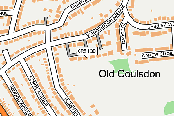
CR5 1QD lies on Waddington Close in Coulsdon. CR5 1QD is located in the Old Coulsdon electoral ward, within the London borough of Croydon and the English Parliamentary constituency of Croydon South. The Sub Integrated Care Board (ICB) Location is NHS South West London ICB - 36L and the police force is Metropolitan Police. This postcode has been in use since July 1990.


GetTheData
Source: OS OpenMap – Local (Ordnance Survey)
Source: OS VectorMap District (Ordnance Survey)
Licence: Open Government Licence (requires attribution)
| Easting | 531680 |
| Northing | 157510 |
| Latitude | 51.301491 |
| Longitude | -0.112502 |
GetTheData
Source: Open Postcode Geo
Licence: Open Government Licence
| Street | Waddington Close |
| Town/City | Coulsdon |
| Country | England |
| Postcode District | CR5 |
➜ See where CR5 is on a map ➜ Where is Coulsdon? | |
GetTheData
Source: Land Registry Price Paid Data
Licence: Open Government Licence
Elevation or altitude of CR5 1QD as distance above sea level:
| Metres | Feet | |
|---|---|---|
| Elevation | 160m | 525ft |
Elevation is measured from the approximate centre of the postcode, to the nearest point on an OS contour line from OS Terrain 50, which has contour spacing of ten vertical metres.
➜ How high above sea level am I? Find the elevation of your current position using your device's GPS.
GetTheData
Source: Open Postcode Elevation
Licence: Open Government Licence
| Ward | Old Coulsdon |
| Constituency | Croydon South |
GetTheData
Source: ONS Postcode Database
Licence: Open Government Licence
| Waddington Avenuehomefield Rd (Waddington Avenue) | Old Coulsdon | 95m |
| Waddington Avenuehomefield Rd (Waddington Avenue) | Old Coulsdon | 110m |
| Homefield Road | Old Coulsdon | 115m |
| Homefield Road | Old Coulsdon | 152m |
| Shirley Avenue | Old Coulsdon | 176m |
| Whyteleafe Station | 2.4km |
| Coulsdon South Station | 2.4km |
| Whyteleafe South Station | 2.5km |
GetTheData
Source: NaPTAN
Licence: Open Government Licence
| Percentage of properties with Next Generation Access | 100.0% |
| Percentage of properties with Superfast Broadband | 100.0% |
| Percentage of properties with Ultrafast Broadband | 25.0% |
| Percentage of properties with Full Fibre Broadband | 0.0% |
Superfast Broadband is between 30Mbps and 300Mbps
Ultrafast Broadband is > 300Mbps
| Percentage of properties unable to receive 2Mbps | 0.0% |
| Percentage of properties unable to receive 5Mbps | 0.0% |
| Percentage of properties unable to receive 10Mbps | 0.0% |
| Percentage of properties unable to receive 30Mbps | 0.0% |
GetTheData
Source: Ofcom
Licence: Ofcom Terms of Use (requires attribution)
GetTheData
Source: ONS Postcode Database
Licence: Open Government Licence


➜ Get more ratings from the Food Standards Agency
GetTheData
Source: Food Standards Agency
Licence: FSA terms & conditions
| Last Collection | |||
|---|---|---|---|
| Location | Mon-Fri | Sat | Distance |
| Keston Avenue(30) | 16:00 | 12:00 | 370m |
| Caterham Drive (179) | 16:30 | 12:00 | 604m |
| The Fox(The Fox Pub) | 16:00 | 12:00 | 671m |
GetTheData
Source: Dracos
Licence: Creative Commons Attribution-ShareAlike
The below table lists the International Territorial Level (ITL) codes (formerly Nomenclature of Territorial Units for Statistics (NUTS) codes) and Local Administrative Units (LAU) codes for CR5 1QD:
| ITL 1 Code | Name |
|---|---|
| TLI | London |
| ITL 2 Code | Name |
| TLI6 | Outer London - South |
| ITL 3 Code | Name |
| TLI62 | Croydon |
| LAU 1 Code | Name |
| E09000008 | Croydon |
GetTheData
Source: ONS Postcode Directory
Licence: Open Government Licence
The below table lists the Census Output Area (OA), Lower Layer Super Output Area (LSOA), and Middle Layer Super Output Area (MSOA) for CR5 1QD:
| Code | Name | |
|---|---|---|
| OA | E00005091 | |
| LSOA | E01001022 | Croydon 044E |
| MSOA | E02000237 | Croydon 044 |
GetTheData
Source: ONS Postcode Directory
Licence: Open Government Licence
| CR5 1QF | Waddington Avenue | 51m |
| CR5 1QQ | Lingfield Gardens | 65m |
| CR5 1QJ | Waddington Avenue | 106m |
| CR5 1ET | Homefield Road | 123m |
| CR5 1QT | Darcy Close | 156m |
| CR5 1SF | Taunton Lane | 159m |
| CR5 1ES | Homefield Road | 175m |
| CR5 1LR | Forge Avenue | 188m |
| CR5 1SJ | Taunton Lane | 215m |
| CR5 1SE | Taunton Lane | 225m |
GetTheData
Source: Open Postcode Geo; Land Registry Price Paid Data
Licence: Open Government Licence