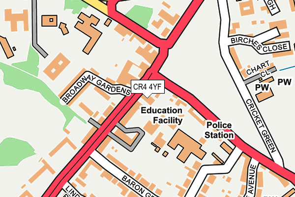
CR4 4YF is located in the Cricket Green electoral ward, within the London borough of Merton and the English Parliamentary constituency of Mitcham and Morden. The Sub Integrated Care Board (ICB) Location is NHS South West London ICB - 36L and the police force is Metropolitan Police. This postcode has been in use since July 1995.


GetTheData
Source: OS OpenMap – Local (Ordnance Survey)
Source: OS VectorMap District (Ordnance Survey)
Licence: Open Government Licence (requires attribution)
| Easting | 527489 |
| Northing | 168429 |
| Latitude | 51.400575 |
| Longitude | -0.168678 |
GetTheData
Source: Open Postcode Geo
Licence: Open Government Licence
| Country | England |
| Postcode District | CR4 |
➜ See where CR4 is on a map ➜ Where is London? | |
GetTheData
Source: Land Registry Price Paid Data
Licence: Open Government Licence
Elevation or altitude of CR4 4YF as distance above sea level:
| Metres | Feet | |
|---|---|---|
| Elevation | 20m | 66ft |
Elevation is measured from the approximate centre of the postcode, to the nearest point on an OS contour line from OS Terrain 50, which has contour spacing of ten vertical metres.
➜ How high above sea level am I? Find the elevation of your current position using your device's GPS.
GetTheData
Source: Open Postcode Elevation
Licence: Open Government Licence
| Ward | Cricket Green |
| Constituency | Mitcham And Morden |
GetTheData
Source: ONS Postcode Database
Licence: Open Government Licence
| Mitcham Cricket Green | Mitcham | 50m |
| Mitcham Cricket Green (London Road) | Mitcham | 54m |
| Mitcham Cricket Green (Cricket Green) | Mitcham | 89m |
| Lower Green West | Mitcham | 129m |
| Mitcham Lower Green | Mitcham | 165m |
| Mitcham Tram Stop (Off London Road) | Mitcham | 376m |
| Belgrave Walk Tram Stop (Belgrave Walk) | Morden | 685m |
| Phipps Bridge Tram Stop (New Close-phipps Bridge) | Morden | 998m |
| Mitcham Junction Tram Stop (Off Carshalton Road) | Mitcham | 1,123m |
| Mitcham Junction Station | 1.1km |
| Mitcham Eastfields Station | 1.3km |
| Morden South Station | 2.2km |
GetTheData
Source: NaPTAN
Licence: Open Government Licence
GetTheData
Source: ONS Postcode Database
Licence: Open Government Licence


➜ Get more ratings from the Food Standards Agency
GetTheData
Source: Food Standards Agency
Licence: FSA terms & conditions
| Last Collection | |||
|---|---|---|---|
| Location | Mon-Fri | Sat | Distance |
| London Road (380) | 17:00 | 12:00 | 48m |
| Bramcote Avenue | 16:45 | 12:00 | 239m |
| Glebe Path (2) | 17:15 | 12:00 | 314m |
GetTheData
Source: Dracos
Licence: Creative Commons Attribution-ShareAlike
The below table lists the International Territorial Level (ITL) codes (formerly Nomenclature of Territorial Units for Statistics (NUTS) codes) and Local Administrative Units (LAU) codes for CR4 4YF:
| ITL 1 Code | Name |
|---|---|
| TLI | London |
| ITL 2 Code | Name |
| TLI6 | Outer London - South |
| ITL 3 Code | Name |
| TLI63 | Merton, Kingston upon Thames and Sutton |
| LAU 1 Code | Name |
| E09000024 | Merton |
GetTheData
Source: ONS Postcode Directory
Licence: Open Government Licence
The below table lists the Census Output Area (OA), Lower Layer Super Output Area (LSOA), and Middle Layer Super Output Area (MSOA) for CR4 4YF:
| Code | Name | |
|---|---|---|
| OA | E00017096 | |
| LSOA | E01003374 | Merton 022A |
| MSOA | E02000710 | Merton 022 |
GetTheData
Source: ONS Postcode Directory
Licence: Open Government Licence
| CR4 4BE | London Road | 74m |
| CR4 3ND | London Road | 85m |
| CR4 4EA | London Road | 91m |
| CR4 4LA | Cricket Green | 123m |
| CR4 4EL | Church Path | 128m |
| CR4 3AF | Lower Green West | 128m |
| CR4 4EF | Broadway Gardens | 134m |
| CR4 4EE | Broadway Gardens | 150m |
| CR4 4EH | Baron Grove | 183m |
| CR4 4ES | London Road | 200m |
GetTheData
Source: Open Postcode Geo; Land Registry Price Paid Data
Licence: Open Government Licence