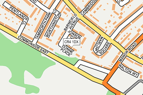
CR4 1DX lies on Donne Place in Mitcham. CR4 1DX is located in the Longthornton electoral ward, within the London borough of Merton and the English Parliamentary constituency of Mitcham and Morden. The Sub Integrated Care Board (ICB) Location is NHS South West London ICB - 36L and the police force is Metropolitan Police. This postcode has been in use since January 1980.


GetTheData
Source: OS OpenMap – Local (Ordnance Survey)
Source: OS VectorMap District (Ordnance Survey)
Licence: Open Government Licence (requires attribution)
| Easting | 528941 |
| Northing | 168446 |
| Latitude | 51.400399 |
| Longitude | -0.147811 |
GetTheData
Source: Open Postcode Geo
Licence: Open Government Licence
| Street | Donne Place |
| Town/City | Mitcham |
| Country | England |
| Postcode District | CR4 |
➜ See where CR4 is on a map ➜ Where is London? | |
GetTheData
Source: Land Registry Price Paid Data
Licence: Open Government Licence
Elevation or altitude of CR4 1DX as distance above sea level:
| Metres | Feet | |
|---|---|---|
| Elevation | 30m | 98ft |
Elevation is measured from the approximate centre of the postcode, to the nearest point on an OS contour line from OS Terrain 50, which has contour spacing of ten vertical metres.
➜ How high above sea level am I? Find the elevation of your current position using your device's GPS.
GetTheData
Source: Open Postcode Elevation
Licence: Open Government Licence
| Ward | Longthornton |
| Constituency | Mitcham And Morden |
GetTheData
Source: ONS Postcode Database
Licence: Open Government Licence
| Tamworth Park | Mitcham | 140m |
| Sherwood Park Road (Cr4) | Mitcham | 148m |
| Tamworth Park Tamworth Lane | Mitcham | 148m |
| Tamworth Park | Mitcham | 192m |
| Sherwood Park Road (Cr4) (Manor Road) | Mitcham | 216m |
| Mitcham Junction Tram Stop (Off Carshalton Road) | Mitcham | 1,110m |
| Beddington Lane Tram Stop (Off Beddington Lane) | Beddington Corner | 1,302m |
| Mitcham Eastfields Station | 0.9km |
| Mitcham Junction Station | 1.1km |
| Norbury Station | 2.2km |
GetTheData
Source: NaPTAN
Licence: Open Government Licence
| Percentage of properties with Next Generation Access | 100.0% |
| Percentage of properties with Superfast Broadband | 100.0% |
| Percentage of properties with Ultrafast Broadband | 100.0% |
| Percentage of properties with Full Fibre Broadband | 0.0% |
Superfast Broadband is between 30Mbps and 300Mbps
Ultrafast Broadband is > 300Mbps
| Median download speed | 42.6Mbps |
| Average download speed | 45.8Mbps |
| Maximum download speed | 100.00Mbps |
| Median upload speed | 8.9Mbps |
| Average upload speed | 9.9Mbps |
| Maximum upload speed | 18.30Mbps |
| Percentage of properties unable to receive 2Mbps | 0.0% |
| Percentage of properties unable to receive 5Mbps | 0.0% |
| Percentage of properties unable to receive 10Mbps | 0.0% |
| Percentage of properties unable to receive 30Mbps | 0.0% |
GetTheData
Source: Ofcom
Licence: Ofcom Terms of Use (requires attribution)
Estimated total energy consumption in CR4 1DX by fuel type, 2015.
| Consumption (kWh) | 141,312 |
|---|---|
| Meter count | 16 |
| Mean (kWh/meter) | 8,832 |
| Median (kWh/meter) | 9,821 |
| Consumption (kWh) | 52,643 |
|---|---|
| Meter count | 16 |
| Mean (kWh/meter) | 3,290 |
| Median (kWh/meter) | 2,764 |
GetTheData
Source: Postcode level gas estimates: 2015 (experimental)
Source: Postcode level electricity estimates: 2015 (experimental)
Licence: Open Government Licence
GetTheData
Source: ONS Postcode Database
Licence: Open Government Licence


➜ Get more ratings from the Food Standards Agency
GetTheData
Source: Food Standards Agency
Licence: FSA terms & conditions
| Last Collection | |||
|---|---|---|---|
| Location | Mon-Fri | Sat | Distance |
| Commonside East (275) | 18:45 | 12:00 | 135m |
| Tamworth Lane (303) | 16:30 | 12:00 | 141m |
| Commonside East (337a) | 18:45 | 12:00 | 193m |
GetTheData
Source: Dracos
Licence: Creative Commons Attribution-ShareAlike
The below table lists the International Territorial Level (ITL) codes (formerly Nomenclature of Territorial Units for Statistics (NUTS) codes) and Local Administrative Units (LAU) codes for CR4 1DX:
| ITL 1 Code | Name |
|---|---|
| TLI | London |
| ITL 2 Code | Name |
| TLI6 | Outer London - South |
| ITL 3 Code | Name |
| TLI63 | Merton, Kingston upon Thames and Sutton |
| LAU 1 Code | Name |
| E09000024 | Merton |
GetTheData
Source: ONS Postcode Directory
Licence: Open Government Licence
The below table lists the Census Output Area (OA), Lower Layer Super Output Area (LSOA), and Middle Layer Super Output Area (MSOA) for CR4 1DX:
| Code | Name | |
|---|---|---|
| OA | E00017375 | |
| LSOA | E01003435 | Merton 014E |
| MSOA | E02000702 | Merton 014 |
GetTheData
Source: ONS Postcode Directory
Licence: Open Government Licence
| CR4 1DP | Jonson Close | 71m |
| CR4 1DN | Barnfield Avenue | 82m |
| CR4 1DF | Tamworth Lane | 104m |
| CR4 1DT | Marlowe Square | 107m |
| CR4 1JQ | Worthington Close | 109m |
| CR4 1HE | Commonside East | 126m |
| CR4 1HD | Commonside East | 140m |
| CR4 1DL | Tamworth Lane | 145m |
| CR4 1HY | Tamworth Park | 147m |
| CR4 1HZ | Tamworth Park | 185m |
GetTheData
Source: Open Postcode Geo; Land Registry Price Paid Data
Licence: Open Government Licence