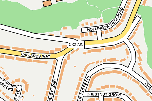
CR2 7JN lies on Ballards Way in South Croydon. CR2 7JN is located in the Selsdon & Addington Village electoral ward, within the London borough of Croydon and the English Parliamentary constituency of Croydon South. The Sub Integrated Care Board (ICB) Location is NHS South West London ICB - 36L and the police force is Metropolitan Police. This postcode has been in use since January 1980.


GetTheData
Source: OS OpenMap – Local (Ordnance Survey)
Source: OS VectorMap District (Ordnance Survey)
Licence: Open Government Licence (requires attribution)
| Easting | 534811 |
| Northing | 163582 |
| Latitude | 51.355325 |
| Longitude | -0.065295 |
GetTheData
Source: Open Postcode Geo
Licence: Open Government Licence
| Street | Ballards Way |
| Town/City | South Croydon |
| Country | England |
| Postcode District | CR2 |
➜ See where CR2 is on a map ➜ Where is Croydon? | |
GetTheData
Source: Land Registry Price Paid Data
Licence: Open Government Licence
Elevation or altitude of CR2 7JN as distance above sea level:
| Metres | Feet | |
|---|---|---|
| Elevation | 110m | 361ft |
Elevation is measured from the approximate centre of the postcode, to the nearest point on an OS contour line from OS Terrain 50, which has contour spacing of ten vertical metres.
➜ How high above sea level am I? Find the elevation of your current position using your device's GPS.
GetTheData
Source: Open Postcode Elevation
Licence: Open Government Licence
| Ward | Selsdon & Addington Village |
| Constituency | Croydon South |
GetTheData
Source: ONS Postcode Database
Licence: Open Government Licence
| Farley Road Croham Valley Rd (Farley Road) | Selsdon/South Croydon | 397m |
| Farley Road Croham Valley Rd (Farley Road) | Selsdon/South Croydon | 400m |
| Ballards Way (Croham Valley Road) | Selsdon/South Croydon | 508m |
| Littleheath Road (Farley Road) | Selsdon/South Croydon | 538m |
| Ballards Way (Croham Valley Road) | Selsdon/South Croydon | 538m |
| Coombe Lane Tram Stop (Coombe Lane) | Upper Shirley | 638m |
| Lloyd Park Tram Stop (Coombe Road) | South Croydon | 1,466m |
| Sanderstead Station | 2.1km |
| South Croydon Station | 2.1km |
| Purley Oaks Station | 2.5km |
GetTheData
Source: NaPTAN
Licence: Open Government Licence
| Percentage of properties with Next Generation Access | 100.0% |
| Percentage of properties with Superfast Broadband | 100.0% |
| Percentage of properties with Ultrafast Broadband | 100.0% |
| Percentage of properties with Full Fibre Broadband | 0.0% |
Superfast Broadband is between 30Mbps and 300Mbps
Ultrafast Broadband is > 300Mbps
| Percentage of properties unable to receive 2Mbps | 0.0% |
| Percentage of properties unable to receive 5Mbps | 0.0% |
| Percentage of properties unable to receive 10Mbps | 0.0% |
| Percentage of properties unable to receive 30Mbps | 0.0% |
GetTheData
Source: Ofcom
Licence: Ofcom Terms of Use (requires attribution)
GetTheData
Source: ONS Postcode Database
Licence: Open Government Licence


➜ Get more ratings from the Food Standards Agency
GetTheData
Source: Food Standards Agency
Licence: FSA terms & conditions
| Last Collection | |||
|---|---|---|---|
| Location | Mon-Fri | Sat | Distance |
| Farley Road(158) | 16:00 | 12:00 | 514m |
| Coombe Lane (Heathfield) | 17:30 | 12:00 | 714m |
| Coombe Lane | 16:15 | 12:00 | 850m |
GetTheData
Source: Dracos
Licence: Creative Commons Attribution-ShareAlike
The below table lists the International Territorial Level (ITL) codes (formerly Nomenclature of Territorial Units for Statistics (NUTS) codes) and Local Administrative Units (LAU) codes for CR2 7JN:
| ITL 1 Code | Name |
|---|---|
| TLI | London |
| ITL 2 Code | Name |
| TLI6 | Outer London - South |
| ITL 3 Code | Name |
| TLI62 | Croydon |
| LAU 1 Code | Name |
| E09000008 | Croydon |
GetTheData
Source: ONS Postcode Directory
Licence: Open Government Licence
The below table lists the Census Output Area (OA), Lower Layer Super Output Area (LSOA), and Middle Layer Super Output Area (MSOA) for CR2 7JN:
| Code | Name | |
|---|---|---|
| OA | E00005596 | |
| LSOA | E01001122 | Croydon 033B |
| MSOA | E02000226 | Croydon 033 |
GetTheData
Source: ONS Postcode Directory
Licence: Open Government Licence
| CR0 5RL | Ballards Farm Road | 91m |
| CR2 7LT | The Ruffetts | 93m |
| CR2 7LA | Ballards Way | 106m |
| CR2 7LR | The Ruffetts | 138m |
| CR0 5RP | Hollingsworth Road | 156m |
| CR2 7JQ | Crest Road | 169m |
| CR2 7JR | Crest Road | 178m |
| CR2 7LS | The Ruffetts | 217m |
| CR2 7JP | Ballards Way | 245m |
| CR2 7JS | Ruffetts Close | 264m |
GetTheData
Source: Open Postcode Geo; Land Registry Price Paid Data
Licence: Open Government Licence