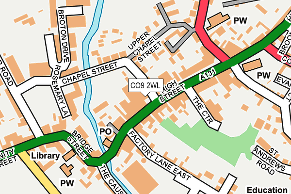
CO9 2WL is located in the Halstead St Andrew's electoral ward, within the local authority district of Braintree and the English Parliamentary constituency of Braintree. The Sub Integrated Care Board (ICB) Location is NHS Mid and South Essex ICB - 06Q and the police force is Essex. This postcode has been in use since January 2020.


GetTheData
Source: OS OpenMap – Local (Ordnance Survey)
Source: OS VectorMap District (Ordnance Survey)
Licence: Open Government Licence (requires attribution)
| Easting | 581306 |
| Northing | 230627 |
| Latitude | 51.944603 |
| Longitude | 0.636511 |
GetTheData
Source: Open Postcode Geo
Licence: Open Government Licence
| Country | England |
| Postcode District | CO9 |
➜ See where CO9 is on a map ➜ Where is Halstead? | |
GetTheData
Source: Land Registry Price Paid Data
Licence: Open Government Licence
Elevation or altitude of CO9 2WL as distance above sea level:
| Metres | Feet | |
|---|---|---|
| Elevation | 40m | 131ft |
Elevation is measured from the approximate centre of the postcode, to the nearest point on an OS contour line from OS Terrain 50, which has contour spacing of ten vertical metres.
➜ How high above sea level am I? Find the elevation of your current position using your device's GPS.
GetTheData
Source: Open Postcode Elevation
Licence: Open Government Licence
| Ward | Halstead St Andrew's |
| Constituency | Braintree |
GetTheData
Source: ONS Postcode Database
Licence: Open Government Licence
| High Street | Halstead | 85m |
| High Street | Halstead | 92m |
| Butler Road Car Park (Butler Road) | Halstead | 242m |
| The Woodman (Colchester Road) | Halstead | 351m |
| Halstead Park (Trinity Street) | Halstead | 361m |
GetTheData
Source: NaPTAN
Licence: Open Government Licence
GetTheData
Source: ONS Postcode Database
Licence: Open Government Licence


➜ Get more ratings from the Food Standards Agency
GetTheData
Source: Food Standards Agency
Licence: FSA terms & conditions
| Last Collection | |||
|---|---|---|---|
| Location | Mon-Fri | Sat | Distance |
| Broton Drive | 17:15 | 12:15 | 212m |
| Trinity Street | 17:15 | 12:15 | 362m |
| Neale Road | 17:15 | 12:15 | 425m |
GetTheData
Source: Dracos
Licence: Creative Commons Attribution-ShareAlike
The below table lists the International Territorial Level (ITL) codes (formerly Nomenclature of Territorial Units for Statistics (NUTS) codes) and Local Administrative Units (LAU) codes for CO9 2WL:
| ITL 1 Code | Name |
|---|---|
| TLH | East |
| ITL 2 Code | Name |
| TLH3 | Essex |
| ITL 3 Code | Name |
| TLH34 | Essex Haven Gateway |
| LAU 1 Code | Name |
| E07000067 | Braintree |
GetTheData
Source: ONS Postcode Directory
Licence: Open Government Licence
The below table lists the Census Output Area (OA), Lower Layer Super Output Area (LSOA), and Middle Layer Super Output Area (MSOA) for CO9 2WL:
| Code | Name | |
|---|---|---|
| OA | E00108632 | |
| LSOA | E01021387 | Braintree 004A |
| MSOA | E02004449 | Braintree 004 |
GetTheData
Source: ONS Postcode Directory
Licence: Open Government Licence
| CO9 2JB | High Street | 43m |
| CO9 2JD | High Street | 48m |
| CO9 2LR | Chapel Street | 63m |
| CO9 2LT | Oak Yard | 90m |
| CO9 2JG | High Street | 98m |
| CO9 2AP | High Street | 98m |
| CO9 2AA | High Street | 104m |
| CO9 2LS | Chapel Street | 108m |
| CO9 2LU | Papermill Cottages | 109m |
| CO9 2DT | Elizabeth Way | 110m |
GetTheData
Source: Open Postcode Geo; Land Registry Price Paid Data
Licence: Open Government Licence