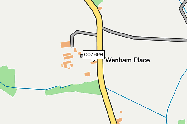
CO7 6PH is located in the Copdock & Washbrook electoral ward, within the local authority district of Babergh and the English Parliamentary constituency of South Suffolk. The Sub Integrated Care Board (ICB) Location is NHS Suffolk and North East Essex ICB - 06L and the police force is Suffolk. This postcode has been in use since January 1980.


GetTheData
Source: OS OpenMap – Local (Ordnance Survey)
Source: OS VectorMap District (Ordnance Survey)
Licence: Open Government Licence (requires attribution)
| Easting | 607194 |
| Northing | 237760 |
| Latitude | 51.999605 |
| Longitude | 1.016907 |
GetTheData
Source: Open Postcode Geo
Licence: Open Government Licence
| Country | England |
| Postcode District | CO7 |
➜ See where CO7 is on a map | |
GetTheData
Source: Land Registry Price Paid Data
Licence: Open Government Licence
Elevation or altitude of CO7 6PH as distance above sea level:
| Metres | Feet | |
|---|---|---|
| Elevation | 40m | 131ft |
Elevation is measured from the approximate centre of the postcode, to the nearest point on an OS contour line from OS Terrain 50, which has contour spacing of ten vertical metres.
➜ How high above sea level am I? Find the elevation of your current position using your device's GPS.
GetTheData
Source: Open Postcode Elevation
Licence: Open Government Licence
| Ward | Copdock & Washbrook |
| Constituency | South Suffolk |
GetTheData
Source: ONS Postcode Database
Licence: Open Government Licence
| Church Close | Great Wenham | 517m |
| Church Close | Great Wenham | 527m |
| Queens Head (The Row) | Great Wenham | 882m |
| Queens Head (The Row) | Great Wenham | 897m |
| Windmill Hill (Mill Hill) | Capel St Mary | 1,346m |
GetTheData
Source: NaPTAN
Licence: Open Government Licence
GetTheData
Source: ONS Postcode Database
Licence: Open Government Licence

➜ Get more ratings from the Food Standards Agency
GetTheData
Source: Food Standards Agency
Licence: FSA terms & conditions
| Last Collection | |||
|---|---|---|---|
| Location | Mon-Fri | Sat | Distance |
| Days Green | 16:30 | 09:45 | 1,821m |
| Post Office, The Street | 16:45 | 10:00 | 2,212m |
| Carriers Arms | 16:45 | 10:30 | 2,410m |
GetTheData
Source: Dracos
Licence: Creative Commons Attribution-ShareAlike
The below table lists the International Territorial Level (ITL) codes (formerly Nomenclature of Territorial Units for Statistics (NUTS) codes) and Local Administrative Units (LAU) codes for CO7 6PH:
| ITL 1 Code | Name |
|---|---|
| TLH | East |
| ITL 2 Code | Name |
| TLH1 | East Anglia |
| ITL 3 Code | Name |
| TLH14 | Suffolk CC |
| LAU 1 Code | Name |
| E07000200 | Babergh |
GetTheData
Source: ONS Postcode Directory
Licence: Open Government Licence
The below table lists the Census Output Area (OA), Lower Layer Super Output Area (LSOA), and Middle Layer Super Output Area (MSOA) for CO7 6PH:
| Code | Name | |
|---|---|---|
| OA | E00152402 | |
| LSOA | E01029905 | Babergh 010G |
| MSOA | E02006236 | Babergh 010 |
GetTheData
Source: ONS Postcode Directory
Licence: Open Government Licence
| CO7 6PJ | Wenham Lane | 205m |
| CO7 6PL | Church Lane | 380m |
| CO7 6PT | Church Close | 488m |
| CO7 6PS | Wenham Road | 656m |
| CO7 6PU | The Row | 977m |
| IP9 2JZ | Lattinford Bridge | 1104m |
| CO7 6PQ | Ipswich Road | 1147m |
| CO7 6PG | Ipswich Road | 1191m |
| CO7 6QE | Coopers Corner | 1258m |
| IP9 2JG | Mill Close | 1264m |
GetTheData
Source: Open Postcode Geo; Land Registry Price Paid Data
Licence: Open Government Licence