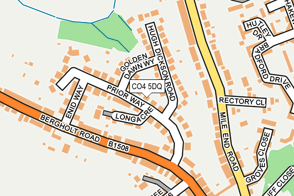
CO4 5DQ lies on Prior Way in Colchester. CO4 5DQ is located in the Mile End electoral ward, within the local authority district of Colchester and the English Parliamentary constituency of Colchester. The Sub Integrated Care Board (ICB) Location is NHS Suffolk and North East Essex ICB - 06T and the police force is Essex. This postcode has been in use since January 1980.


GetTheData
Source: OS OpenMap – Local (Ordnance Survey)
Source: OS VectorMap District (Ordnance Survey)
Licence: Open Government Licence (requires attribution)
| Easting | 599073 |
| Northing | 226772 |
| Latitude | 51.903909 |
| Longitude | 0.892411 |
GetTheData
Source: Open Postcode Geo
Licence: Open Government Licence
| Street | Prior Way |
| Town/City | Colchester |
| Country | England |
| Postcode District | CO4 |
➜ See where CO4 is on a map ➜ Where is Colchester? | |
GetTheData
Source: Land Registry Price Paid Data
Licence: Open Government Licence
Elevation or altitude of CO4 5DQ as distance above sea level:
| Metres | Feet | |
|---|---|---|
| Elevation | 30m | 98ft |
Elevation is measured from the approximate centre of the postcode, to the nearest point on an OS contour line from OS Terrain 50, which has contour spacing of ten vertical metres.
➜ How high above sea level am I? Find the elevation of your current position using your device's GPS.
GetTheData
Source: Open Postcode Elevation
Licence: Open Government Licence
| Ward | Mile End |
| Constituency | Colchester |
GetTheData
Source: ONS Postcode Database
Licence: Open Government Licence
15, PRIOR WAY, COLCHESTER, CO4 5DQ 2000 31 JAN £84,000 |
15, PRIOR WAY, COLCHESTER, CO4 5DQ 1999 31 MAR £64,500 |
19, PRIOR WAY, COLCHESTER, CO4 5DQ 1995 30 JUN £55,000 |
19, PRIOR WAY, COLCHESTER, CO4 5DQ 1995 6 MAR £27,500 |
GetTheData
Source: HM Land Registry Price Paid Data
Licence: Contains HM Land Registry data © Crown copyright and database right 2025. This data is licensed under the Open Government Licence v3.0.
| Enid Way (Bergholt Road) | Colchester | 127m |
| Enid Way (Bergholt Road) | Colchester | 144m |
| Rectory Close (Mile End Road) | Colchester | 148m |
| Oaks Place (Mile End Road) | Colchester | 157m |
| Oaks Place (Mile End Road) | Colchester | 256m |
| Colchester Station | 0.4km |
| Colchester Town Station | 2.1km |
| Hythe (Essex) Station | 3.2km |
GetTheData
Source: NaPTAN
Licence: Open Government Licence
| Percentage of properties with Next Generation Access | 100.0% |
| Percentage of properties with Superfast Broadband | 100.0% |
| Percentage of properties with Ultrafast Broadband | 0.0% |
| Percentage of properties with Full Fibre Broadband | 0.0% |
Superfast Broadband is between 30Mbps and 300Mbps
Ultrafast Broadband is > 300Mbps
| Median download speed | 56.9Mbps |
| Average download speed | 52.3Mbps |
| Maximum download speed | 74.73Mbps |
| Median upload speed | 17.5Mbps |
| Average upload speed | 14.6Mbps |
| Maximum upload speed | 20.00Mbps |
| Percentage of properties unable to receive 2Mbps | 0.0% |
| Percentage of properties unable to receive 5Mbps | 0.0% |
| Percentage of properties unable to receive 10Mbps | 0.0% |
| Percentage of properties unable to receive 30Mbps | 0.0% |
GetTheData
Source: Ofcom
Licence: Ofcom Terms of Use (requires attribution)
Estimated total energy consumption in CO4 5DQ by fuel type, 2015.
| Consumption (kWh) | 177,836 |
|---|---|
| Meter count | 18 |
| Mean (kWh/meter) | 9,880 |
| Median (kWh/meter) | 8,763 |
| Consumption (kWh) | 37,896 |
|---|---|
| Meter count | 15 |
| Mean (kWh/meter) | 2,526 |
| Median (kWh/meter) | 2,156 |
GetTheData
Source: Postcode level gas estimates: 2015 (experimental)
Source: Postcode level electricity estimates: 2015 (experimental)
Licence: Open Government Licence
GetTheData
Source: ONS Postcode Database
Licence: Open Government Licence


➜ Get more ratings from the Food Standards Agency
GetTheData
Source: Food Standards Agency
Licence: FSA terms & conditions
| Last Collection | |||
|---|---|---|---|
| Location | Mon-Fri | Sat | Distance |
| North Station Down | 18:30 | 12:00 | 368m |
| Bergholt Road | 17:30 | 11:30 | 403m |
| Peto Avenue | 17:30 | 12:00 | 608m |
GetTheData
Source: Dracos
Licence: Creative Commons Attribution-ShareAlike
The below table lists the International Territorial Level (ITL) codes (formerly Nomenclature of Territorial Units for Statistics (NUTS) codes) and Local Administrative Units (LAU) codes for CO4 5DQ:
| ITL 1 Code | Name |
|---|---|
| TLH | East |
| ITL 2 Code | Name |
| TLH3 | Essex |
| ITL 3 Code | Name |
| TLH34 | Essex Haven Gateway |
| LAU 1 Code | Name |
| E07000071 | Colchester |
GetTheData
Source: ONS Postcode Directory
Licence: Open Government Licence
The below table lists the Census Output Area (OA), Lower Layer Super Output Area (LSOA), and Middle Layer Super Output Area (MSOA) for CO4 5DQ:
| Code | Name | |
|---|---|---|
| OA | E00110132 | |
| LSOA | E01021679 | Colchester 004A |
| MSOA | E02004509 | Colchester 004 |
GetTheData
Source: ONS Postcode Directory
Licence: Open Government Licence
| CO4 5DD | Hugh Dickson Road | 71m |
| CO4 5DR | Longacre | 82m |
| CO4 5DF | Golden Dawn Way | 83m |
| CO4 5DG | Prior Way | 90m |
| CO4 5DH | Prior Way | 95m |
| CO4 5AF | Bergholt Road | 96m |
| CO4 5AG | Bergholt Road | 126m |
| CO4 5DE | Hugh Dickson Road | 126m |
| CO4 5AE | Bergholt Road | 133m |
| CO4 5AQ | Bergholt Road | 150m |
GetTheData
Source: Open Postcode Geo; Land Registry Price Paid Data
Licence: Open Government Licence