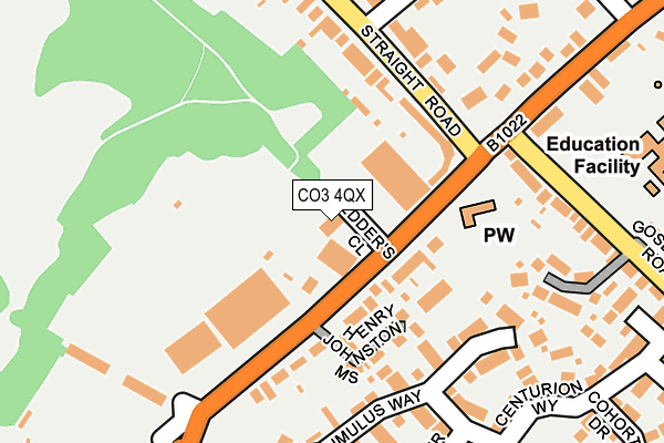
CO3 4QX lies on Pedders Close in Colchester. CO3 4QX is located in the Prettygate electoral ward, within the local authority district of Colchester and the English Parliamentary constituency of Colchester. The Sub Integrated Care Board (ICB) Location is NHS Suffolk and North East Essex ICB - 06T and the police force is Essex. This postcode has been in use since January 1983.


GetTheData
Source: OS OpenMap – Local (Ordnance Survey)
Source: OS VectorMap District (Ordnance Survey)
Licence: Open Government Licence (requires attribution)
| Easting | 596921 |
| Northing | 223144 |
| Latitude | 51.872095 |
| Longitude | 0.859102 |
GetTheData
Source: Open Postcode Geo
Licence: Open Government Licence
| Street | Pedders Close |
| Town/City | Colchester |
| Country | England |
| Postcode District | CO3 |
➜ See where CO3 is on a map ➜ Where is Colchester? | |
GetTheData
Source: Land Registry Price Paid Data
Licence: Open Government Licence
Elevation or altitude of CO3 4QX as distance above sea level:
| Metres | Feet | |
|---|---|---|
| Elevation | 40m | 131ft |
Elevation is measured from the approximate centre of the postcode, to the nearest point on an OS contour line from OS Terrain 50, which has contour spacing of ten vertical metres.
➜ How high above sea level am I? Find the elevation of your current position using your device's GPS.
GetTheData
Source: Open Postcode Elevation
Licence: Open Government Licence
| Ward | Prettygate |
| Constituency | Colchester |
GetTheData
Source: ONS Postcode Database
Licence: Open Government Licence
2, PEDDERS CLOSE, COLCHESTER, CO3 4QX 2014 14 FEB £216,000 |
GetTheData
Source: HM Land Registry Price Paid Data
Licence: Contains HM Land Registry data © Crown copyright and database right 2025. This data is licensed under the Open Government Licence v3.0.
| Ash Way (Straight Road) | Colchester | 141m |
| Leather Bottle (Shrub End Road) | Shrub End | 189m |
| Baden Powell Drive (Straight Road) | Colchester | 224m |
| Gosbecks Road | Shrub End | 236m |
| Gosbecks Road | Shrub End | 241m |
| Colchester Town Station | 3.5km |
| Colchester Station | 3.9km |
| Hythe (Essex) Station | 4.9km |
GetTheData
Source: NaPTAN
Licence: Open Government Licence
GetTheData
Source: ONS Postcode Database
Licence: Open Government Licence


➜ Get more ratings from the Food Standards Agency
GetTheData
Source: Food Standards Agency
Licence: FSA terms & conditions
| Last Collection | |||
|---|---|---|---|
| Location | Mon-Fri | Sat | Distance |
| Straight Road South | 17:30 | 11:30 | 190m |
| Gladiator Way | 17:30 | 11:30 | 373m |
| Baden Powell Drive | 17:30 | 11:30 | 484m |
GetTheData
Source: Dracos
Licence: Creative Commons Attribution-ShareAlike
The below table lists the International Territorial Level (ITL) codes (formerly Nomenclature of Territorial Units for Statistics (NUTS) codes) and Local Administrative Units (LAU) codes for CO3 4QX:
| ITL 1 Code | Name |
|---|---|
| TLH | East |
| ITL 2 Code | Name |
| TLH3 | Essex |
| ITL 3 Code | Name |
| TLH34 | Essex Haven Gateway |
| LAU 1 Code | Name |
| E07000071 | Colchester |
GetTheData
Source: ONS Postcode Directory
Licence: Open Government Licence
The below table lists the Census Output Area (OA), Lower Layer Super Output Area (LSOA), and Middle Layer Super Output Area (MSOA) for CO3 4QX:
| Code | Name | |
|---|---|---|
| OA | E00110187 | |
| LSOA | E01021690 | Colchester 014B |
| MSOA | E02004519 | Colchester 014 |
GetTheData
Source: ONS Postcode Directory
Licence: Open Government Licence
| CO3 4RP | Shrub End Road | 81m |
| CO3 4RL | Shrub End Road | 92m |
| CO3 4RW | Shrub End Road | 114m |
| CO3 4RN | Shrub End Road | 117m |
| CO3 4BT | Henry Johnston Mews | 123m |
| CO3 9FN | Ash Way | 123m |
| CO3 9EE | Straight Road | 143m |
| CO2 9SD | Tumulus Way | 164m |
| CO3 9DY | Straight Road | 166m |
| CO2 9TA | Springfields Drive | 204m |
GetTheData
Source: Open Postcode Geo; Land Registry Price Paid Data
Licence: Open Government Licence