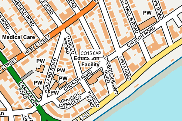
CO15 6AP lies on Church Road in Clacton-on-sea. CO15 6AP is located in the Pier electoral ward, within the local authority district of Tendring and the English Parliamentary constituency of Clacton. The Sub Integrated Care Board (ICB) Location is NHS Suffolk and North East Essex ICB - 06T and the police force is Essex. This postcode has been in use since January 1980.


GetTheData
Source: OS OpenMap – Local (Ordnance Survey)
Source: OS VectorMap District (Ordnance Survey)
Licence: Open Government Licence (requires attribution)
| Easting | 618035 |
| Northing | 214978 |
| Latitude | 51.790952 |
| Longitude | 1.160219 |
GetTheData
Source: Open Postcode Geo
Licence: Open Government Licence
| Street | Church Road |
| Town/City | Clacton-on-sea |
| Country | England |
| Postcode District | CO15 |
➜ See where CO15 is on a map ➜ Where is Clacton-on-Sea? | |
GetTheData
Source: Land Registry Price Paid Data
Licence: Open Government Licence
Elevation or altitude of CO15 6AP as distance above sea level:
| Metres | Feet | |
|---|---|---|
| Elevation | 10m | 33ft |
Elevation is measured from the approximate centre of the postcode, to the nearest point on an OS contour line from OS Terrain 50, which has contour spacing of ten vertical metres.
➜ How high above sea level am I? Find the elevation of your current position using your device's GPS.
GetTheData
Source: Open Postcode Elevation
Licence: Open Government Licence
| Ward | Pier |
| Constituency | Clacton |
GetTheData
Source: ONS Postcode Database
Licence: Open Government Licence
| Thoroughgood Road (Skelmersdale Road) | Clacton | 340m |
| Avondale Road (Skelmersdale Road) | Clacton | 341m |
| Avondale Road (Skelmersdale Road) | Clacton | 353m |
| Thoroughgood Road (Skelmersdale Road) | Clacton | 365m |
| Station Road | Clacton | 466m |
| Clacton-on-Sea Station | 0.5km |
GetTheData
Source: NaPTAN
Licence: Open Government Licence
| Percentage of properties with Next Generation Access | 100.0% |
| Percentage of properties with Superfast Broadband | 100.0% |
| Percentage of properties with Ultrafast Broadband | 0.0% |
| Percentage of properties with Full Fibre Broadband | 0.0% |
Superfast Broadband is between 30Mbps and 300Mbps
Ultrafast Broadband is > 300Mbps
| Median download speed | 22.7Mbps |
| Average download speed | 28.4Mbps |
| Maximum download speed | 60.38Mbps |
| Median upload speed | 1.2Mbps |
| Average upload speed | 5.3Mbps |
| Maximum upload speed | 16.93Mbps |
| Percentage of properties unable to receive 2Mbps | 0.0% |
| Percentage of properties unable to receive 5Mbps | 0.0% |
| Percentage of properties unable to receive 10Mbps | 0.0% |
| Percentage of properties unable to receive 30Mbps | 0.0% |
GetTheData
Source: Ofcom
Licence: Ofcom Terms of Use (requires attribution)
GetTheData
Source: ONS Postcode Database
Licence: Open Government Licence

➜ Get more ratings from the Food Standards Agency
GetTheData
Source: Food Standards Agency
Licence: FSA terms & conditions
| Last Collection | |||
|---|---|---|---|
| Location | Mon-Fri | Sat | Distance |
| High Street | 17:15 | 11:00 | 131m |
| Vista Road | 17:00 | 11:00 | 134m |
| Anglefield | 17:00 | 11:00 | 215m |
GetTheData
Source: Dracos
Licence: Creative Commons Attribution-ShareAlike
The below table lists the International Territorial Level (ITL) codes (formerly Nomenclature of Territorial Units for Statistics (NUTS) codes) and Local Administrative Units (LAU) codes for CO15 6AP:
| ITL 1 Code | Name |
|---|---|
| TLH | East |
| ITL 2 Code | Name |
| TLH3 | Essex |
| ITL 3 Code | Name |
| TLH34 | Essex Haven Gateway |
| LAU 1 Code | Name |
| E07000076 | Tendring |
GetTheData
Source: ONS Postcode Directory
Licence: Open Government Licence
The below table lists the Census Output Area (OA), Lower Layer Super Output Area (LSOA), and Middle Layer Super Output Area (MSOA) for CO15 6AP:
| Code | Name | |
|---|---|---|
| OA | E00111907 | |
| LSOA | E01022027 | Tendring 016D |
| MSOA | E02004588 | Tendring 016 |
GetTheData
Source: ONS Postcode Directory
Licence: Open Government Licence
| CO15 6AS | Church Road | 52m |
| CO15 6AL | Harold Road | 64m |
| CO15 6AJ | Harold Road | 68m |
| CO15 6AN | Thoroughgood Road | 81m |
| CO15 6AR | Thoroughgood Road | 81m |
| CO15 6JX | Thoroughgood Road | 87m |
| CO15 6AW | The Limes | 88m |
| CO15 6JF | Harold Road | 96m |
| CO15 6AE | Harold Road | 97m |
| CO15 6JG | Marine Parade East | 106m |
GetTheData
Source: Open Postcode Geo; Land Registry Price Paid Data
Licence: Open Government Licence