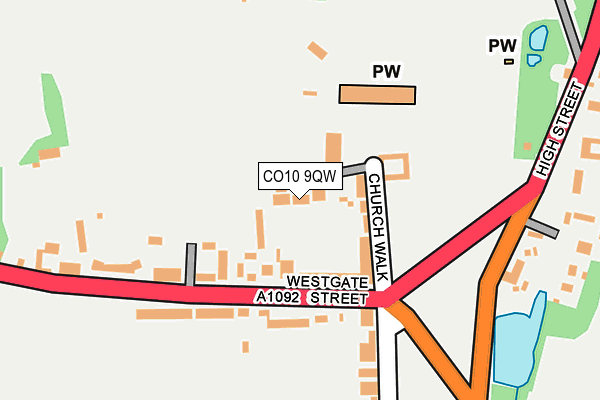
CO10 9QW lies on Rectory Gardens in Long Melford, Sudbury. CO10 9QW is located in the Long Melford electoral ward, within the local authority district of Babergh and the English Parliamentary constituency of South Suffolk. The Sub Integrated Care Board (ICB) Location is NHS Suffolk and North East Essex ICB - 07K and the police force is Suffolk. This postcode has been in use since June 1997.


GetTheData
Source: OS OpenMap – Local (Ordnance Survey)
Source: OS VectorMap District (Ordnance Survey)
Licence: Open Government Licence (requires attribution)
| Easting | 586437 |
| Northing | 246654 |
| Latitude | 52.086844 |
| Longitude | 0.719793 |
GetTheData
Source: Open Postcode Geo
Licence: Open Government Licence
| Street | Rectory Gardens |
| Locality | Long Melford |
| Town/City | Sudbury |
| Country | England |
| Postcode District | CO10 |
➜ See where CO10 is on a map ➜ Where is Long Melford? | |
GetTheData
Source: Land Registry Price Paid Data
Licence: Open Government Licence
Elevation or altitude of CO10 9QW as distance above sea level:
| Metres | Feet | |
|---|---|---|
| Elevation | 50m | 164ft |
Elevation is measured from the approximate centre of the postcode, to the nearest point on an OS contour line from OS Terrain 50, which has contour spacing of ten vertical metres.
➜ How high above sea level am I? Find the elevation of your current position using your device's GPS.
GetTheData
Source: Open Postcode Elevation
Licence: Open Government Licence
| Ward | Long Melford |
| Constituency | South Suffolk |
GetTheData
Source: ONS Postcode Database
Licence: Open Government Licence
2019 6 MAR £520,000 |
2, RECTORY GARDENS, LONG MELFORD, SUDBURY, CO10 9QW 2009 31 JUL £435,000 |
1, RECTORY GARDENS, LONG MELFORD, SUDBURY, CO10 9QW 2005 4 FEB £420,000 |
2, RECTORY GARDENS, LONG MELFORD, SUDBURY, CO10 9QW 2002 19 AUG £240,000 |
2, RECTORY GARDENS, LONG MELFORD, SUDBURY, CO10 9QW 1997 6 AUG £180,000 |
4, RECTORY GARDENS, LONG MELFORD, SUDBURY, CO10 9QW 1997 18 JUL £170,000 |
1997 27 JUN £165,000 |
1, RECTORY GARDENS, LONG MELFORD, SUDBURY, CO10 9QW 1997 3 JUN £180,000 |
GetTheData
Source: HM Land Registry Price Paid Data
Licence: Contains HM Land Registry data © Crown copyright and database right 2025. This data is licensed under the Open Government Licence v3.0.
| Black Lion | Long Melford | 111m |
| Black Lion | Long Melford | 122m |
| Harefield (High Street) | High Street | 454m |
| Harefield (High Street) | High Street | 465m |
| Bull (Hall Street) | Long Melford | 793m |
GetTheData
Source: NaPTAN
Licence: Open Government Licence
| Percentage of properties with Next Generation Access | 100.0% |
| Percentage of properties with Superfast Broadband | 100.0% |
| Percentage of properties with Ultrafast Broadband | 0.0% |
| Percentage of properties with Full Fibre Broadband | 0.0% |
Superfast Broadband is between 30Mbps and 300Mbps
Ultrafast Broadband is > 300Mbps
| Percentage of properties unable to receive 2Mbps | 0.0% |
| Percentage of properties unable to receive 5Mbps | 0.0% |
| Percentage of properties unable to receive 10Mbps | 0.0% |
| Percentage of properties unable to receive 30Mbps | 0.0% |
GetTheData
Source: Ofcom
Licence: Ofcom Terms of Use (requires attribution)
GetTheData
Source: ONS Postcode Database
Licence: Open Government Licence


➜ Get more ratings from the Food Standards Agency
GetTheData
Source: Food Standards Agency
Licence: FSA terms & conditions
| Last Collection | |||
|---|---|---|---|
| Location | Mon-Fri | Sat | Distance |
| Long Melford Church | 16:45 | 10:30 | 82m |
| Windmill Hill Long Melford | 16:30 | 10:30 | 802m |
| Shaw Road Long Melford | 16:45 | 10:30 | 823m |
GetTheData
Source: Dracos
Licence: Creative Commons Attribution-ShareAlike
The below table lists the International Territorial Level (ITL) codes (formerly Nomenclature of Territorial Units for Statistics (NUTS) codes) and Local Administrative Units (LAU) codes for CO10 9QW:
| ITL 1 Code | Name |
|---|---|
| TLH | East |
| ITL 2 Code | Name |
| TLH1 | East Anglia |
| ITL 3 Code | Name |
| TLH14 | Suffolk CC |
| LAU 1 Code | Name |
| E07000200 | Babergh |
GetTheData
Source: ONS Postcode Directory
Licence: Open Government Licence
The below table lists the Census Output Area (OA), Lower Layer Super Output Area (LSOA), and Middle Layer Super Output Area (MSOA) for CO10 9QW:
| Code | Name | |
|---|---|---|
| OA | E00152374 | |
| LSOA | E01029901 | Babergh 003B |
| MSOA | E02006229 | Babergh 003 |
GetTheData
Source: ONS Postcode Directory
Licence: Open Government Licence
| CO10 9DP | Westgate Street | 61m |
| CO10 9DL | Church Walk | 65m |
| CO10 9DW | Westgate Terrace | 85m |
| CO10 9DN | Church Walk | 99m |
| CO10 9DT | The Green | 140m |
| CO10 9DS | Westgate Street | 146m |
| CO10 9DR | Westgate Street | 153m |
| CO10 9DU | The Green | 263m |
| CO10 9DH | High Street | 267m |
| CO10 9DG | High Street | 289m |
GetTheData
Source: Open Postcode Geo; Land Registry Price Paid Data
Licence: Open Government Licence