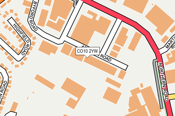
CO10 2YW lies on Addison Road in Sudbury. CO10 2YW is located in the Sudbury South East electoral ward, within the local authority district of Babergh and the English Parliamentary constituency of South Suffolk. The Sub Integrated Care Board (ICB) Location is NHS Suffolk and North East Essex ICB - 07K and the police force is Suffolk. This postcode has been in use since December 1998.


GetTheData
Source: OS OpenMap – Local (Ordnance Survey)
Source: OS VectorMap District (Ordnance Survey)
Licence: Open Government Licence (requires attribution)
| Easting | 588534 |
| Northing | 241996 |
| Latitude | 52.044304 |
| Longitude | 0.747793 |
GetTheData
Source: Open Postcode Geo
Licence: Open Government Licence
| Street | Addison Road |
| Town/City | Sudbury |
| Country | England |
| Postcode District | CO10 |
➜ See where CO10 is on a map ➜ Where is Sudbury? | |
GetTheData
Source: Land Registry Price Paid Data
Licence: Open Government Licence
Elevation or altitude of CO10 2YW as distance above sea level:
| Metres | Feet | |
|---|---|---|
| Elevation | 60m | 197ft |
Elevation is measured from the approximate centre of the postcode, to the nearest point on an OS contour line from OS Terrain 50, which has contour spacing of ten vertical metres.
➜ How high above sea level am I? Find the elevation of your current position using your device's GPS.
GetTheData
Source: Open Postcode Elevation
Licence: Open Government Licence
| Ward | Sudbury South East |
| Constituency | South Suffolk |
GetTheData
Source: ONS Postcode Database
Licence: Open Government Licence
| Chilton Industrial Estate (A134) | Sudbury | 220m |
| Chilton Industrial Estate (A134) | Sudbury | 237m |
| Deben Drive (Landsdown Road) | Sudbury | 342m |
| Deben Drive (Landsdown Road) | Sudbury | 346m |
| Industrial Estate (Windham Road) | Chilton | 376m |
| Sudbury (Suffolk) Station | 1.2km |
GetTheData
Source: NaPTAN
Licence: Open Government Licence
| Median download speed | 10.2Mbps |
| Average download speed | 23.4Mbps |
| Maximum download speed | 80.00Mbps |
| Median upload speed | 0.9Mbps |
| Average upload speed | 5.4Mbps |
| Maximum upload speed | 20.00Mbps |
GetTheData
Source: Ofcom
Licence: Ofcom Terms of Use (requires attribution)
Estimated total energy consumption in CO10 2YW by fuel type, 2015.
| Consumption (kWh) | 269,624 |
|---|---|
| Meter count | 8 |
| Mean (kWh/meter) | 33,703 |
| Median (kWh/meter) | 28,363 |
GetTheData
Source: Postcode level gas estimates: 2015 (experimental)
Source: Postcode level electricity estimates: 2015 (experimental)
Licence: Open Government Licence
GetTheData
Source: ONS Postcode Database
Licence: Open Government Licence


➜ Get more ratings from the Food Standards Agency
GetTheData
Source: Food Standards Agency
Licence: FSA terms & conditions
| Last Collection | |||
|---|---|---|---|
| Location | Mon-Fri | Sat | Distance |
| Sudbury Delivery Office | 18:00 | 12:30 | 413m |
| Lansdown Road | 17:15 | 11:30 | 448m |
| Acton Lane | 17:15 | 11:30 | 921m |
GetTheData
Source: Dracos
Licence: Creative Commons Attribution-ShareAlike
The below table lists the International Territorial Level (ITL) codes (formerly Nomenclature of Territorial Units for Statistics (NUTS) codes) and Local Administrative Units (LAU) codes for CO10 2YW:
| ITL 1 Code | Name |
|---|---|
| TLH | East |
| ITL 2 Code | Name |
| TLH1 | East Anglia |
| ITL 3 Code | Name |
| TLH14 | Suffolk CC |
| LAU 1 Code | Name |
| E07000200 | Babergh |
GetTheData
Source: ONS Postcode Directory
Licence: Open Government Licence
The below table lists the Census Output Area (OA), Lower Layer Super Output Area (LSOA), and Middle Layer Super Output Area (MSOA) for CO10 2YW:
| Code | Name | |
|---|---|---|
| OA | E00152450 | |
| LSOA | E01029913 | Babergh 007B |
| MSOA | E02006233 | Babergh 007 |
GetTheData
Source: ONS Postcode Directory
Licence: Open Government Licence
| CO10 2YG | Byford Road | 278m |
| CO10 2QJ | Highfield Road | 286m |
| CO10 2XD | Chilton Industrial Estate | 287m |
| CO10 2QG | Landsdown Road | 321m |
| CO10 2QQ | Landsdown Road | 333m |
| CO10 2QS | Waldingfield Road | 353m |
| CO10 2QH | Deben Drive | 384m |
| CO10 2PZ | Waldingfield Road | 399m |
| CO10 2QF | Landsdown Road | 400m |
| CO10 2YR | The Cloisters | 405m |
GetTheData
Source: Open Postcode Geo; Land Registry Price Paid Data
Licence: Open Government Licence