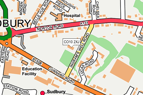
CO10 2XJ is located in the Sudbury South West electoral ward, within the local authority district of Babergh and the English Parliamentary constituency of South Suffolk. The Sub Integrated Care Board (ICB) Location is NHS Suffolk and North East Essex ICB - 07K and the police force is Suffolk. This postcode has been in use since December 1998.


GetTheData
Source: OS OpenMap – Local (Ordnance Survey)
Source: OS VectorMap District (Ordnance Survey)
Licence: Open Government Licence (requires attribution)
| Easting | 587835 |
| Northing | 241260 |
| Latitude | 52.037918 |
| Longitude | 0.737178 |
GetTheData
Source: Open Postcode Geo
Licence: Open Government Licence
| Country | England |
| Postcode District | CO10 |
➜ See where CO10 is on a map ➜ Where is Sudbury? | |
GetTheData
Source: Land Registry Price Paid Data
Licence: Open Government Licence
Elevation or altitude of CO10 2XJ as distance above sea level:
| Metres | Feet | |
|---|---|---|
| Elevation | 40m | 131ft |
Elevation is measured from the approximate centre of the postcode, to the nearest point on an OS contour line from OS Terrain 50, which has contour spacing of ten vertical metres.
➜ How high above sea level am I? Find the elevation of your current position using your device's GPS.
GetTheData
Source: Open Postcode Elevation
Licence: Open Government Licence
| Ward | Sudbury South West |
| Constituency | South Suffolk |
GetTheData
Source: ONS Postcode Database
Licence: Open Government Licence
| Lucas Road (Cornard Road) | Sudbury | 154m |
| Lucas Road (Cornard Road) | Sudbury | 169m |
| Cemetery Gates (Newton Road) | Sudbury | 240m |
| Cemetery Gates (Newton Road) | Sudbury | 251m |
| Sainsbury's | Sudbury | 275m |
| Sudbury (Suffolk) Station | 0.2km |
GetTheData
Source: NaPTAN
Licence: Open Government Licence
| Percentage of properties with Next Generation Access | 100.0% |
| Percentage of properties with Superfast Broadband | 100.0% |
| Percentage of properties with Ultrafast Broadband | 0.0% |
| Percentage of properties with Full Fibre Broadband | 0.0% |
Superfast Broadband is between 30Mbps and 300Mbps
Ultrafast Broadband is > 300Mbps
| Percentage of properties unable to receive 2Mbps | 0.0% |
| Percentage of properties unable to receive 5Mbps | 0.0% |
| Percentage of properties unable to receive 10Mbps | 0.0% |
| Percentage of properties unable to receive 30Mbps | 0.0% |
GetTheData
Source: Ofcom
Licence: Ofcom Terms of Use (requires attribution)
GetTheData
Source: ONS Postcode Database
Licence: Open Government Licence


➜ Get more ratings from the Food Standards Agency
GetTheData
Source: Food Standards Agency
Licence: FSA terms & conditions
| Last Collection | |||
|---|---|---|---|
| Location | Mon-Fri | Sat | Distance |
| Great Eastern Road | 17:30 | 11:30 | 318m |
| Sudbury Post Office | 17:30 | 12:00 | 375m |
| Sudbury Post Office | 17:30 | 12:00 | 375m |
GetTheData
Source: Dracos
Licence: Creative Commons Attribution-ShareAlike
The below table lists the International Territorial Level (ITL) codes (formerly Nomenclature of Territorial Units for Statistics (NUTS) codes) and Local Administrative Units (LAU) codes for CO10 2XJ:
| ITL 1 Code | Name |
|---|---|
| TLH | East |
| ITL 2 Code | Name |
| TLH1 | East Anglia |
| ITL 3 Code | Name |
| TLH14 | Suffolk CC |
| LAU 1 Code | Name |
| E07000200 | Babergh |
GetTheData
Source: ONS Postcode Directory
Licence: Open Government Licence
The below table lists the Census Output Area (OA), Lower Layer Super Output Area (LSOA), and Middle Layer Super Output Area (MSOA) for CO10 2XJ:
| Code | Name | |
|---|---|---|
| OA | E00152469 | |
| LSOA | E01029918 | Babergh 007F |
| MSOA | E02006233 | Babergh 007 |
GetTheData
Source: ONS Postcode Directory
Licence: Open Government Licence
| CO10 2RT | Ingrams Well Road | 23m |
| CO10 2RL | Newton Road | 85m |
| CO10 2WR | Lucas Road | 88m |
| CO10 2WS | Lucas Road | 107m |
| CO10 2RU | Chelsea Road | 172m |
| CO10 2RD | Cornard Road | 173m |
| CO10 2PR | Burroughs Piece Road | 198m |
| CO10 2XA | Cornard Road | 208m |
| CO10 2PP | Belle Vue Road | 216m |
| CO10 2RN | Newton Road | 224m |
GetTheData
Source: Open Postcode Geo; Land Registry Price Paid Data
Licence: Open Government Licence