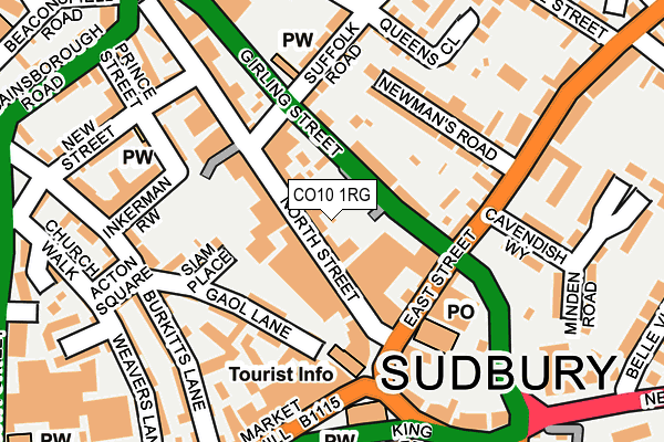
CO10 1RG is located in the Sudbury North West electoral ward, within the local authority district of Babergh and the English Parliamentary constituency of South Suffolk. The Sub Integrated Care Board (ICB) Location is NHS Suffolk and North East Essex ICB - 07K and the police force is Suffolk. This postcode has been in use since June 2003.


GetTheData
Source: OS OpenMap – Local (Ordnance Survey)
Source: OS VectorMap District (Ordnance Survey)
Licence: Open Government Licence (requires attribution)
| Easting | 587407 |
| Northing | 241499 |
| Latitude | 52.040209 |
| Longitude | 0.731076 |
GetTheData
Source: Open Postcode Geo
Licence: Open Government Licence
| Country | England |
| Postcode District | CO10 |
➜ See where CO10 is on a map ➜ Where is Sudbury? | |
GetTheData
Source: Land Registry Price Paid Data
Licence: Open Government Licence
Elevation or altitude of CO10 1RG as distance above sea level:
| Metres | Feet | |
|---|---|---|
| Elevation | 40m | 131ft |
Elevation is measured from the approximate centre of the postcode, to the nearest point on an OS contour line from OS Terrain 50, which has contour spacing of ten vertical metres.
➜ How high above sea level am I? Find the elevation of your current position using your device's GPS.
GetTheData
Source: Open Postcode Elevation
Licence: Open Government Licence
| Ward | Sudbury North West |
| Constituency | South Suffolk |
GetTheData
Source: ONS Postcode Database
Licence: Open Government Licence
| Post Office (East Street) | Sudbury | 105m |
| Suffolk Road (Girling Street) | Sudbury | 135m |
| Cavendish Way (East Street) | Sudbury | 148m |
| Cavendish Way (East Street) | Sudbury | 161m |
| York Road | Sudbury | 278m |
| Sudbury (Suffolk) Station | 0.5km |
GetTheData
Source: NaPTAN
Licence: Open Government Licence
GetTheData
Source: ONS Postcode Database
Licence: Open Government Licence


➜ Get more ratings from the Food Standards Agency
GetTheData
Source: Food Standards Agency
Licence: FSA terms & conditions
| Last Collection | |||
|---|---|---|---|
| Location | Mon-Fri | Sat | Distance |
| Sudbury Post Office | 17:30 | 12:00 | 120m |
| Sudbury Post Office | 17:30 | 12:00 | 120m |
| Market Hill | 17:30 | 12:00 | 252m |
GetTheData
Source: Dracos
Licence: Creative Commons Attribution-ShareAlike
The below table lists the International Territorial Level (ITL) codes (formerly Nomenclature of Territorial Units for Statistics (NUTS) codes) and Local Administrative Units (LAU) codes for CO10 1RG:
| ITL 1 Code | Name |
|---|---|
| TLH | East |
| ITL 2 Code | Name |
| TLH1 | East Anglia |
| ITL 3 Code | Name |
| TLH14 | Suffolk CC |
| LAU 1 Code | Name |
| E07000200 | Babergh |
GetTheData
Source: ONS Postcode Directory
Licence: Open Government Licence
The below table lists the Census Output Area (OA), Lower Layer Super Output Area (LSOA), and Middle Layer Super Output Area (MSOA) for CO10 1RG:
| Code | Name | |
|---|---|---|
| OA | E00152471 | |
| LSOA | E01029920 | Babergh 007H |
| MSOA | E02006233 | Babergh 007 |
GetTheData
Source: ONS Postcode Directory
Licence: Open Government Licence
| CO10 1RF | North Street | 16m |
| CO10 1RB | North Street | 43m |
| CO10 1LZ | Girling Street | 61m |
| CO10 1JH | Siam Place | 107m |
| CO10 1JL | Gaol Lane | 119m |
| CO10 1UA | Newmans Road | 123m |
| CO10 1JJ | Gaol Lane | 127m |
| CO10 2TP | East Street | 130m |
| CO10 2TW | East Street | 138m |
| CO10 1UN | Suffolk Road | 143m |
GetTheData
Source: Open Postcode Geo; Land Registry Price Paid Data
Licence: Open Government Licence