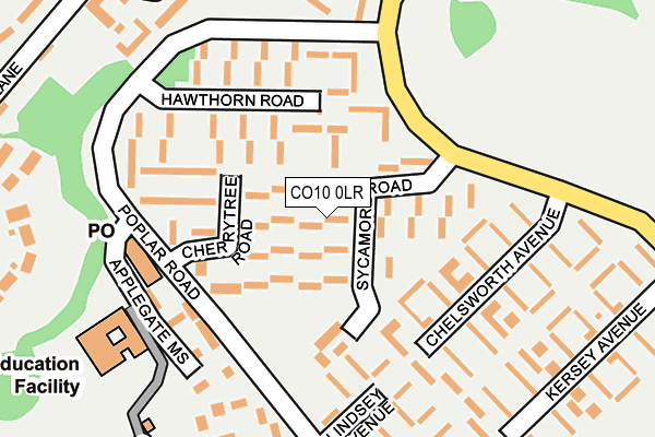
CO10 0LR lies on Sycamore Road in Great Cornard, Sudbury. CO10 0LR is located in the Great Cornard electoral ward, within the local authority district of Babergh and the English Parliamentary constituency of South Suffolk. The Sub Integrated Care Board (ICB) Location is NHS Suffolk and North East Essex ICB - 07K and the police force is Suffolk. This postcode has been in use since January 1980.


GetTheData
Source: OS OpenMap – Local (Ordnance Survey)
Source: OS VectorMap District (Ordnance Survey)
Licence: Open Government Licence (requires attribution)
| Easting | 588710 |
| Northing | 241058 |
| Latitude | 52.035807 |
| Longitude | 0.749808 |
GetTheData
Source: Open Postcode Geo
Licence: Open Government Licence
| Street | Sycamore Road |
| Locality | Great Cornard |
| Town/City | Sudbury |
| Country | England |
| Postcode District | CO10 |
➜ See where CO10 is on a map ➜ Where is Sudbury? | |
GetTheData
Source: Land Registry Price Paid Data
Licence: Open Government Licence
Elevation or altitude of CO10 0LR as distance above sea level:
| Metres | Feet | |
|---|---|---|
| Elevation | 50m | 164ft |
Elevation is measured from the approximate centre of the postcode, to the nearest point on an OS contour line from OS Terrain 50, which has contour spacing of ten vertical metres.
➜ How high above sea level am I? Find the elevation of your current position using your device's GPS.
GetTheData
Source: Open Postcode Elevation
Licence: Open Government Licence
| Ward | Great Cornard |
| Constituency | South Suffolk |
GetTheData
Source: ONS Postcode Database
Licence: Open Government Licence
| Lindsey Avenue (Poplar Road) | Great Cornard | 158m |
| Maldon Court (Poplar Road) | Great Cornard | 168m |
| Maldon Court (Poplar Road) | Great Cornard | 177m |
| Lindsey Avenue (Poplar Road) | Great Cornard | 187m |
| Chelsworth Avenue (Shawlands Avenue) | Great Cornard | 208m |
| Sudbury (Suffolk) Station | 1km |
GetTheData
Source: NaPTAN
Licence: Open Government Licence
| Percentage of properties with Next Generation Access | 100.0% |
| Percentage of properties with Superfast Broadband | 100.0% |
| Percentage of properties with Ultrafast Broadband | 0.0% |
| Percentage of properties with Full Fibre Broadband | 0.0% |
Superfast Broadband is between 30Mbps and 300Mbps
Ultrafast Broadband is > 300Mbps
| Median download speed | 40.0Mbps |
| Average download speed | 39.1Mbps |
| Maximum download speed | 71.93Mbps |
| Median upload speed | 10.0Mbps |
| Average upload speed | 11.1Mbps |
| Maximum upload speed | 20.00Mbps |
| Percentage of properties unable to receive 2Mbps | 0.0% |
| Percentage of properties unable to receive 5Mbps | 0.0% |
| Percentage of properties unable to receive 10Mbps | 0.0% |
| Percentage of properties unable to receive 30Mbps | 0.0% |
GetTheData
Source: Ofcom
Licence: Ofcom Terms of Use (requires attribution)
Estimated total energy consumption in CO10 0LR by fuel type, 2015.
| Consumption (kWh) | 305,621 |
|---|---|
| Meter count | 31 |
| Mean (kWh/meter) | 9,859 |
| Median (kWh/meter) | 9,238 |
| Consumption (kWh) | 115,173 |
|---|---|
| Meter count | 31 |
| Mean (kWh/meter) | 3,715 |
| Median (kWh/meter) | 3,098 |
GetTheData
Source: Postcode level gas estimates: 2015 (experimental)
Source: Postcode level electricity estimates: 2015 (experimental)
Licence: Open Government Licence
GetTheData
Source: ONS Postcode Database
Licence: Open Government Licence


➜ Get more ratings from the Food Standards Agency
GetTheData
Source: Food Standards Agency
Licence: FSA terms & conditions
| Last Collection | |||
|---|---|---|---|
| Location | Mon-Fri | Sat | Distance |
| Poplar Road Great Cornard | 17:15 | 11:30 | 190m |
| Pot Kiln Road Great Cornard | 17:15 | 10:30 | 469m |
| Mede Way Great Cornard | 16:15 | 11:30 | 594m |
GetTheData
Source: Dracos
Licence: Creative Commons Attribution-ShareAlike
The below table lists the International Territorial Level (ITL) codes (formerly Nomenclature of Territorial Units for Statistics (NUTS) codes) and Local Administrative Units (LAU) codes for CO10 0LR:
| ITL 1 Code | Name |
|---|---|
| TLH | East |
| ITL 2 Code | Name |
| TLH1 | East Anglia |
| ITL 3 Code | Name |
| TLH14 | Suffolk CC |
| LAU 1 Code | Name |
| E07000200 | Babergh |
GetTheData
Source: ONS Postcode Directory
Licence: Open Government Licence
The below table lists the Census Output Area (OA), Lower Layer Super Output Area (LSOA), and Middle Layer Super Output Area (MSOA) for CO10 0LR:
| Code | Name | |
|---|---|---|
| OA | E00152304 | |
| LSOA | E01029888 | Babergh 008C |
| MSOA | E02006234 | Babergh 008 |
GetTheData
Source: ONS Postcode Directory
Licence: Open Government Licence
| CO10 0LJ | Cherrytree Road | 73m |
| CO10 0LP | Sycamore Road | 85m |
| CO10 0LW | Hawthorn Road | 131m |
| CO10 0LN | Hawthorn Road | 160m |
| CO10 0LT | Chelsworth Avenue | 161m |
| CO10 0LS | Chelsworth Avenue | 189m |
| CO10 0DT | Lindsey Avenue | 192m |
| CO10 0FX | Butt Road | 243m |
| CO10 0LY | Maldon Court | 257m |
| CO10 0DU | Shelley Avenue | 260m |
GetTheData
Source: Open Postcode Geo; Land Registry Price Paid Data
Licence: Open Government Licence