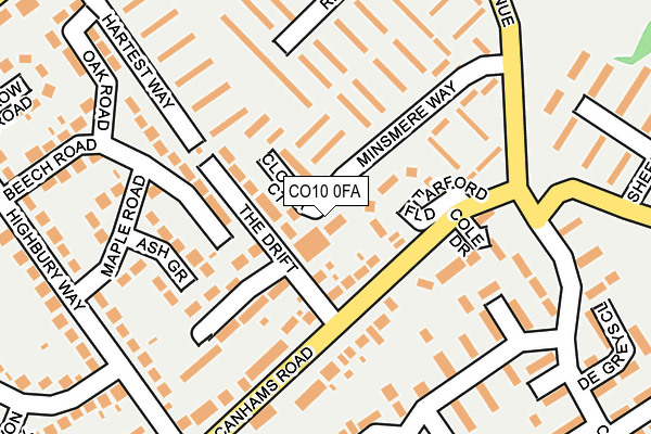
CO10 0FA is located in the Great Cornard electoral ward, within the local authority district of Babergh and the English Parliamentary constituency of South Suffolk. The Sub Integrated Care Board (ICB) Location is NHS Suffolk and North East Essex ICB - 07K and the police force is Suffolk. This postcode has been in use since March 2007.


GetTheData
Source: OS OpenMap – Local (Ordnance Survey)
Source: OS VectorMap District (Ordnance Survey)
Licence: Open Government Licence (requires attribution)
| Easting | 589163 |
| Northing | 240471 |
| Latitude | 52.030394 |
| Longitude | 0.756111 |
GetTheData
Source: Open Postcode Geo
Licence: Open Government Licence
| Country | England |
| Postcode District | CO10 |
➜ See where CO10 is on a map ➜ Where is Sudbury? | |
GetTheData
Source: Land Registry Price Paid Data
Licence: Open Government Licence
Elevation or altitude of CO10 0FA as distance above sea level:
| Metres | Feet | |
|---|---|---|
| Elevation | 30m | 98ft |
Elevation is measured from the approximate centre of the postcode, to the nearest point on an OS contour line from OS Terrain 50, which has contour spacing of ten vertical metres.
➜ How high above sea level am I? Find the elevation of your current position using your device's GPS.
GetTheData
Source: Open Postcode Elevation
Licence: Open Government Licence
| Ward | Great Cornard |
| Constituency | South Suffolk |
GetTheData
Source: ONS Postcode Database
Licence: Open Government Licence
| The Drift (Canhams Road) | Great Cornard | 125m |
| Kempson Drive | Great Cornard | 179m |
| Minsmere Way (Shawlands Avenue) | Great Cornard | 206m |
| Kempson Drive (Carsons Drive) | Great Cornard | 233m |
| Queensway (Highbury Way) | Great Cornard | 235m |
| Sudbury (Suffolk) Station | 1.6km |
GetTheData
Source: NaPTAN
Licence: Open Government Licence
| Percentage of properties with Next Generation Access | 100.0% |
| Percentage of properties with Superfast Broadband | 100.0% |
| Percentage of properties with Ultrafast Broadband | 0.0% |
| Percentage of properties with Full Fibre Broadband | 0.0% |
Superfast Broadband is between 30Mbps and 300Mbps
Ultrafast Broadband is > 300Mbps
| Percentage of properties unable to receive 2Mbps | 0.0% |
| Percentage of properties unable to receive 5Mbps | 0.0% |
| Percentage of properties unable to receive 10Mbps | 0.0% |
| Percentage of properties unable to receive 30Mbps | 0.0% |
GetTheData
Source: Ofcom
Licence: Ofcom Terms of Use (requires attribution)
GetTheData
Source: ONS Postcode Database
Licence: Open Government Licence


➜ Get more ratings from the Food Standards Agency
GetTheData
Source: Food Standards Agency
Licence: FSA terms & conditions
| Last Collection | |||
|---|---|---|---|
| Location | Mon-Fri | Sat | Distance |
| Carsons Drive Great Cornard | 16:00 | 10:30 | 207m |
| Mede Way Great Cornard | 16:15 | 11:30 | 309m |
| Kempson Drive | 16:15 | 10:30 | 357m |
GetTheData
Source: Dracos
Licence: Creative Commons Attribution-ShareAlike
The below table lists the International Territorial Level (ITL) codes (formerly Nomenclature of Territorial Units for Statistics (NUTS) codes) and Local Administrative Units (LAU) codes for CO10 0FA:
| ITL 1 Code | Name |
|---|---|
| TLH | East |
| ITL 2 Code | Name |
| TLH1 | East Anglia |
| ITL 3 Code | Name |
| TLH14 | Suffolk CC |
| LAU 1 Code | Name |
| E07000200 | Babergh |
GetTheData
Source: ONS Postcode Directory
Licence: Open Government Licence
The below table lists the Census Output Area (OA), Lower Layer Super Output Area (LSOA), and Middle Layer Super Output Area (MSOA) for CO10 0FA:
| Code | Name | |
|---|---|---|
| OA | E00152317 | |
| LSOA | E01029889 | Babergh 008D |
| MSOA | E02006234 | Babergh 008 |
GetTheData
Source: ONS Postcode Directory
Licence: Open Government Licence
| CO10 0ET | Farford Field | 54m |
| CO10 0ES | Canhams Road | 86m |
| CO10 0EU | The Drift | 109m |
| CO10 0EX | Oak Road | 114m |
| CO10 0FE | Cole Drive | 131m |
| CO10 0HB | Ash Grove | 133m |
| CO10 0LD | Minsmere Way | 146m |
| CO10 0LB | Minsmere Way | 157m |
| CO10 0ER | Canhams Road | 158m |
| CO10 0ND | Kempson Drive | 170m |
GetTheData
Source: Open Postcode Geo; Land Registry Price Paid Data
Licence: Open Government Licence