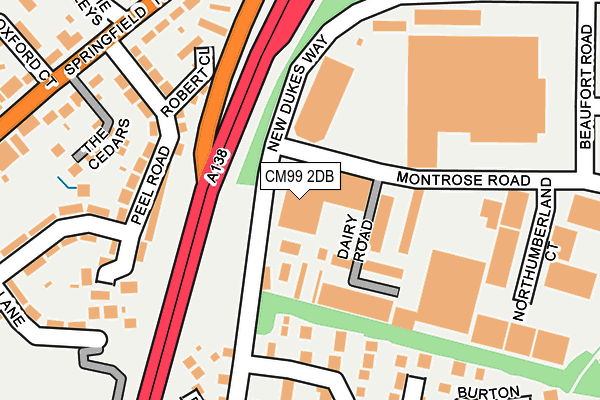
CM99 2DB is located in the Chelmer Village and Beaulieu Park electoral ward, within the local authority district of Chelmsford and the English Parliamentary constituency of Chelmsford. The Sub Integrated Care Board (ICB) Location is NHS Mid and South Essex ICB - 06Q and the police force is Essex. This postcode has been in use since May 2011.


GetTheData
Source: OS OpenMap – Local (Ordnance Survey)
Source: OS VectorMap District (Ordnance Survey)
Licence: Open Government Licence (requires attribution)
| Easting | 572740 |
| Northing | 207824 |
| Latitude | 51.742492 |
| Longitude | 0.500602 |
GetTheData
Source: Open Postcode Geo
Licence: Open Government Licence
| Country | England |
| Postcode District | CM99 |
➜ Where is Chelmsford? | |
GetTheData
Source: Land Registry Price Paid Data
Licence: Open Government Licence
Elevation or altitude of CM99 2DB as distance above sea level:
| Metres | Feet | |
|---|---|---|
| Elevation | 40m | 131ft |
Elevation is measured from the approximate centre of the postcode, to the nearest point on an OS contour line from OS Terrain 50, which has contour spacing of ten vertical metres.
➜ How high above sea level am I? Find the elevation of your current position using your device's GPS.
GetTheData
Source: Open Postcode Elevation
Licence: Open Government Licence
| Ward | Chelmer Village And Beaulieu Park |
| Constituency | Chelmsford |
GetTheData
Source: ONS Postcode Database
Licence: Open Government Licence
| Golding Thoroughfare (New Dukes Way) | Chelmer Village | 73m |
| Golding Thoroughfare (New Dukes Way) | Chelmer Village | 86m |
| Aldi (Springfield Road) | Springfield | 276m |
| Aldi (Springfield Road) | Springfield | 286m |
| The Plough (Springfield Road) | Springfield | 301m |
| Chelmsford Station | 2.3km |
GetTheData
Source: NaPTAN
Licence: Open Government Licence
GetTheData
Source: ONS Postcode Database
Licence: Open Government Licence


➜ Get more ratings from the Food Standards Agency
GetTheData
Source: Food Standards Agency
Licence: FSA terms & conditions
| Last Collection | |||
|---|---|---|---|
| Location | Mon-Fri | Sat | Distance |
| Upper Springfield Road | 17:30 | 11:30 | 353m |
| Essex Distribution Centre | 565m | ||
| Havengore | 17:45 | 11:30 | 589m |
GetTheData
Source: Dracos
Licence: Creative Commons Attribution-ShareAlike
The below table lists the International Territorial Level (ITL) codes (formerly Nomenclature of Territorial Units for Statistics (NUTS) codes) and Local Administrative Units (LAU) codes for CM99 2DB:
| ITL 1 Code | Name |
|---|---|
| TLH | East |
| ITL 2 Code | Name |
| TLH3 | Essex |
| ITL 3 Code | Name |
| TLH36 | Heart of Essex |
| LAU 1 Code | Name |
| E07000070 | Chelmsford |
GetTheData
Source: ONS Postcode Directory
Licence: Open Government Licence
The below table lists the Census Output Area (OA), Lower Layer Super Output Area (LSOA), and Middle Layer Super Output Area (MSOA) for CM99 2DB:
| Code | Name | |
|---|---|---|
| OA | E00109459 | |
| LSOA | E01021544 | Chelmsford 008A |
| MSOA | E02004492 | Chelmsford 008 |
GetTheData
Source: ONS Postcode Directory
Licence: Open Government Licence
| CM2 6XW | Buckingham Court | 110m |
| CM2 6TT | Mearns Place | 136m |
| CM2 6AH | Peel Road | 158m |
| CM2 6AJ | Peel Road | 167m |
| CM2 6TS | Lovibond Place | 172m |
| CM2 6AL | Peel Road | 187m |
| CM2 6FJ | Robert Close | 188m |
| CM2 6TP | Emberson Court | 201m |
| CM2 6BL | The Cedars | 216m |
| CM2 6AD | Dukes Lane | 216m |
GetTheData
Source: Open Postcode Geo; Land Registry Price Paid Data
Licence: Open Government Licence