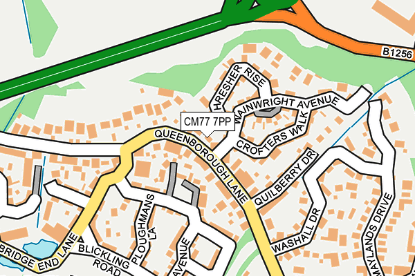
CM77 7PP lies on Queenborough Lane in Braintree. CM77 7PP is located in the Great Notley & Black Notley electoral ward, within the local authority district of Braintree and the English Parliamentary constituency of Braintree. The Sub Integrated Care Board (ICB) Location is NHS Mid and South Essex ICB - 06Q and the police force is Essex. This postcode has been in use since June 2002.


GetTheData
Source: OS OpenMap – Local (Ordnance Survey)
Source: OS VectorMap District (Ordnance Survey)
Licence: Open Government Licence (requires attribution)
| Easting | 574463 |
| Northing | 221740 |
| Latitude | 51.866956 |
| Longitude | 0.532530 |
GetTheData
Source: Open Postcode Geo
Licence: Open Government Licence
| Street | Queenborough Lane |
| Town/City | Braintree |
| Country | England |
| Postcode District | CM77 |
➜ See where CM77 is on a map ➜ Where is Great Notley? | |
GetTheData
Source: Land Registry Price Paid Data
Licence: Open Government Licence
Elevation or altitude of CM77 7PP as distance above sea level:
| Metres | Feet | |
|---|---|---|
| Elevation | 60m | 197ft |
Elevation is measured from the approximate centre of the postcode, to the nearest point on an OS contour line from OS Terrain 50, which has contour spacing of ten vertical metres.
➜ How high above sea level am I? Find the elevation of your current position using your device's GPS.
GetTheData
Source: Open Postcode Elevation
Licence: Open Government Licence
| Ward | Great Notley & Black Notley |
| Constituency | Braintree |
GetTheData
Source: ONS Postcode Database
Licence: Open Government Licence
FANAD, QUEENBOROUGH LANE, BRAINTREE, CM77 7PP 2002 16 DEC £299,750 |
GetTheData
Source: HM Land Registry Price Paid Data
Licence: Contains HM Land Registry data © Crown copyright and database right 2025. This data is licensed under the Open Government Licence v3.0.
| Bridge End Lane (Queenborough Lane) | Great Notley | 99m |
| Bridge End Lane (Queenborough Lane) | Great Notley | 106m |
| Panners Farm (Bridge End Lane) | Great Notley | 274m |
| Greenway Gardens (Queenborough Lane) | Great Notley | 280m |
| Panners Farm (Bridge End Lane) | Great Notley | 282m |
| Braintree Station | 1.9km |
| Braintree Freeport Station | 2.5km |
| Cressing Station | 3.5km |
GetTheData
Source: NaPTAN
Licence: Open Government Licence
| Percentage of properties with Next Generation Access | 100.0% |
| Percentage of properties with Superfast Broadband | 100.0% |
| Percentage of properties with Ultrafast Broadband | 0.0% |
| Percentage of properties with Full Fibre Broadband | 0.0% |
Superfast Broadband is between 30Mbps and 300Mbps
Ultrafast Broadband is > 300Mbps
| Percentage of properties unable to receive 2Mbps | 0.0% |
| Percentage of properties unable to receive 5Mbps | 0.0% |
| Percentage of properties unable to receive 10Mbps | 0.0% |
| Percentage of properties unable to receive 30Mbps | 0.0% |
GetTheData
Source: Ofcom
Licence: Ofcom Terms of Use (requires attribution)
GetTheData
Source: ONS Postcode Database
Licence: Open Government Licence


➜ Get more ratings from the Food Standards Agency
GetTheData
Source: Food Standards Agency
Licence: FSA terms & conditions
| Last Collection | |||
|---|---|---|---|
| Location | Mon-Fri | Sat | Distance |
| Beddalls End | 16:00 | 09:15 | 490m |
| Whitecourts | 16:00 | 09:15 | 853m |
| Tesco Store | 18:45 | 13:00 | 926m |
GetTheData
Source: Dracos
Licence: Creative Commons Attribution-ShareAlike
The below table lists the International Territorial Level (ITL) codes (formerly Nomenclature of Territorial Units for Statistics (NUTS) codes) and Local Administrative Units (LAU) codes for CM77 7PP:
| ITL 1 Code | Name |
|---|---|
| TLH | East |
| ITL 2 Code | Name |
| TLH3 | Essex |
| ITL 3 Code | Name |
| TLH34 | Essex Haven Gateway |
| LAU 1 Code | Name |
| E07000067 | Braintree |
GetTheData
Source: ONS Postcode Directory
Licence: Open Government Licence
The below table lists the Census Output Area (OA), Lower Layer Super Output Area (LSOA), and Middle Layer Super Output Area (MSOA) for CM77 7PP:
| Code | Name | |
|---|---|---|
| OA | E00108616 | |
| LSOA | E01021383 | Braintree 010C |
| MSOA | E02004455 | Braintree 010 |
GetTheData
Source: ONS Postcode Directory
Licence: Open Government Licence
| CM77 7GR | Queenborough Grove | 66m |
| CM77 7GP | Crofters Walk | 103m |
| CM77 7WN | Thresher Rise | 105m |
| CM77 7LJ | Wainwright Avenue | 118m |
| CM77 7QD | Queenborough Lane | 121m |
| CM77 7GG | Quilberry Drive | 127m |
| CM77 7DG | Coopers Crescent | 157m |
| CM77 7YJ | Chestnut Avenue | 195m |
| CM77 7GF | Washall Drive | 203m |
| CM77 7ZJ | Blickling Road | 211m |
GetTheData
Source: Open Postcode Geo; Land Registry Price Paid Data
Licence: Open Government Licence