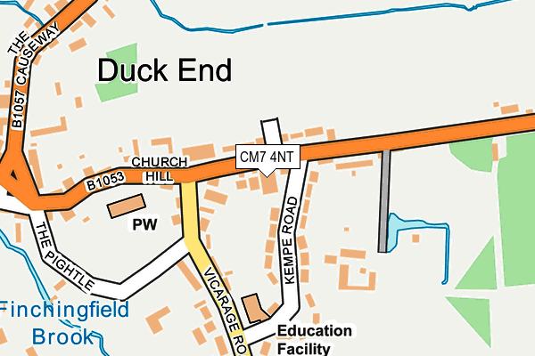
CM7 4NT is located in the Three Fields electoral ward, within the local authority district of Braintree and the English Parliamentary constituency of Braintree. The Sub Integrated Care Board (ICB) Location is NHS Mid and South Essex ICB - 06Q and the police force is Essex. This postcode has been in use since January 1980.


GetTheData
Source: OS OpenMap – Local (Ordnance Survey)
Source: OS VectorMap District (Ordnance Survey)
Licence: Open Government Licence (requires attribution)
| Easting | 568780 |
| Northing | 232835 |
| Latitude | 51.968364 |
| Longitude | 0.455506 |
GetTheData
Source: Open Postcode Geo
Licence: Open Government Licence
| Country | England |
| Postcode District | CM7 |
➜ See where CM7 is on a map ➜ Where is Finchingfield? | |
GetTheData
Source: Land Registry Price Paid Data
Licence: Open Government Licence
Elevation or altitude of CM7 4NT as distance above sea level:
| Metres | Feet | |
|---|---|---|
| Elevation | 70m | 230ft |
Elevation is measured from the approximate centre of the postcode, to the nearest point on an OS contour line from OS Terrain 50, which has contour spacing of ten vertical metres.
➜ How high above sea level am I? Find the elevation of your current position using your device's GPS.
GetTheData
Source: Open Postcode Elevation
Licence: Open Government Licence
| Ward | Three Fields |
| Constituency | Braintree |
GetTheData
Source: ONS Postcode Database
Licence: Open Government Licence
| Kempe Road (B1053 Sampford Road) | Finchingfield | 25m |
| Kempe Road (B1053 Sampford Road) | Finchingfield | 117m |
| Church Hill (The Causeway) | Finchingfield | 292m |
| The Fox (Sunnyside (B1057)) | Finchingfield | 348m |
| The Fox (Sunnyside) | Finchingfield | 355m |
GetTheData
Source: NaPTAN
Licence: Open Government Licence
GetTheData
Source: ONS Postcode Database
Licence: Open Government Licence


➜ Get more ratings from the Food Standards Agency
GetTheData
Source: Food Standards Agency
Licence: FSA terms & conditions
| Last Collection | |||
|---|---|---|---|
| Location | Mon-Fri | Sat | Distance |
| Hawkins Hill | 16:30 | 09:30 | 2,409m |
| Wethersfield P.o. | 16:30 | 10:30 | 2,704m |
| Little Sampford Village | 16:00 | 09:30 | 3,640m |
GetTheData
Source: Dracos
Licence: Creative Commons Attribution-ShareAlike
The below table lists the International Territorial Level (ITL) codes (formerly Nomenclature of Territorial Units for Statistics (NUTS) codes) and Local Administrative Units (LAU) codes for CM7 4NT:
| ITL 1 Code | Name |
|---|---|
| TLH | East |
| ITL 2 Code | Name |
| TLH3 | Essex |
| ITL 3 Code | Name |
| TLH34 | Essex Haven Gateway |
| LAU 1 Code | Name |
| E07000067 | Braintree |
GetTheData
Source: ONS Postcode Directory
Licence: Open Government Licence
The below table lists the Census Output Area (OA), Lower Layer Super Output Area (LSOA), and Middle Layer Super Output Area (MSOA) for CM7 4NT:
| Code | Name | |
|---|---|---|
| OA | E00108773 | |
| LSOA | E01021412 | Braintree 005C |
| MSOA | E02004450 | Braintree 005 |
GetTheData
Source: ONS Postcode Directory
Licence: Open Government Licence
| CM7 4PL | Wethersfield Road | 49m |
| CM7 4NR | Wethersfield Road | 63m |
| CM7 4LE | Kempe Road | 113m |
| CM7 4LD | Vicarage Road | 157m |
| CM7 4NP | Church Hill | 185m |
| CM7 4NN | Church Hill | 210m |
| CM7 4LF | Vicarage Road | 257m |
| CM7 4LB | The Pightle | 263m |
| CM7 4JU | The Causeway | 264m |
| CM7 4NB | Duck End | 275m |
GetTheData
Source: Open Postcode Geo; Land Registry Price Paid Data
Licence: Open Government Licence