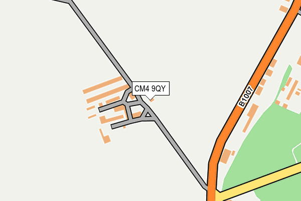
CM4 9QY is located in the South Hanningfield, Stock and Margaretting electoral ward, within the local authority district of Chelmsford and the English Parliamentary constituency of Maldon. The Sub Integrated Care Board (ICB) Location is NHS Mid and South Essex ICB - 06Q and the police force is Essex. This postcode has been in use since January 1980.


GetTheData
Source: OS OpenMap – Local (Ordnance Survey)
Source: OS VectorMap District (Ordnance Survey)
Licence: Open Government Licence (requires attribution)
| Easting | 570267 |
| Northing | 200611 |
| Latitude | 51.678455 |
| Longitude | 0.461298 |
GetTheData
Source: Open Postcode Geo
Licence: Open Government Licence
| Country | England |
| Postcode District | CM4 |
➜ See where CM4 is on a map | |
GetTheData
Source: Land Registry Price Paid Data
Licence: Open Government Licence
Elevation or altitude of CM4 9QY as distance above sea level:
| Metres | Feet | |
|---|---|---|
| Elevation | 90m | 295ft |
Elevation is measured from the approximate centre of the postcode, to the nearest point on an OS contour line from OS Terrain 50, which has contour spacing of ten vertical metres.
➜ How high above sea level am I? Find the elevation of your current position using your device's GPS.
GetTheData
Source: Open Postcode Elevation
Licence: Open Government Licence
| Ward | South Hanningfield, Stock And Margaretting |
| Constituency | Maldon |
GetTheData
Source: ONS Postcode Database
Licence: Open Government Licence
| The Ship (Stock Road) | West Hanningfield | 224m |
| The Ship (Stock Road) | West Hanningfield | 257m |
| Downham Road (Stock Road) | West Hanningfield | 619m |
| Bakers Lane (Stock Road) | West Hanningfield | 629m |
| Downham Road (Stock Road) | West Hanningfield | 716m |
GetTheData
Source: NaPTAN
Licence: Open Government Licence
| Percentage of properties with Next Generation Access | 100.0% |
| Percentage of properties with Superfast Broadband | 100.0% |
| Percentage of properties with Ultrafast Broadband | 0.0% |
| Percentage of properties with Full Fibre Broadband | 0.0% |
Superfast Broadband is between 30Mbps and 300Mbps
Ultrafast Broadband is > 300Mbps
| Percentage of properties unable to receive 2Mbps | 0.0% |
| Percentage of properties unable to receive 5Mbps | 0.0% |
| Percentage of properties unable to receive 10Mbps | 0.0% |
| Percentage of properties unable to receive 30Mbps | 0.0% |
GetTheData
Source: Ofcom
Licence: Ofcom Terms of Use (requires attribution)
GetTheData
Source: ONS Postcode Database
Licence: Open Government Licence


➜ Get more ratings from the Food Standards Agency
GetTheData
Source: Food Standards Agency
Licence: FSA terms & conditions
| Last Collection | |||
|---|---|---|---|
| Location | Mon-Fri | Sat | Distance |
| Ship Inn | 16:00 | 08:30 | 199m |
| Mill Road | 16:30 | 09:00 | 2,003m |
| Crowsfield | 16:15 | 08:15 | 2,668m |
GetTheData
Source: Dracos
Licence: Creative Commons Attribution-ShareAlike
The below table lists the International Territorial Level (ITL) codes (formerly Nomenclature of Territorial Units for Statistics (NUTS) codes) and Local Administrative Units (LAU) codes for CM4 9QY:
| ITL 1 Code | Name |
|---|---|
| TLH | East |
| ITL 2 Code | Name |
| TLH3 | Essex |
| ITL 3 Code | Name |
| TLH36 | Heart of Essex |
| LAU 1 Code | Name |
| E07000070 | Chelmsford |
GetTheData
Source: ONS Postcode Directory
Licence: Open Government Licence
The below table lists the Census Output Area (OA), Lower Layer Super Output Area (LSOA), and Middle Layer Super Output Area (MSOA) for CM4 9QY:
| Code | Name | |
|---|---|---|
| OA | E00109746 | |
| LSOA | E01021602 | Chelmsford 018B |
| MSOA | E02004502 | Chelmsford 018 |
GetTheData
Source: ONS Postcode Directory
Licence: Open Government Licence
| CM2 8LB | Stock Road | 256m |
| CM2 8LA | Stock Road | 256m |
| CM4 9QZ | Stock Road | 365m |
| CM4 9RA | Foxborough Chase | 514m |
| CM4 9QX | Stock Road | 682m |
| CM2 8LE | Bakers Lane | 813m |
| CM4 9RB | Downham Road | 1065m |
| CM2 8FN | Hall Lane | 1184m |
| CM4 9RD | Lower Stock Road | 1304m |
| CM2 8UY | Lower Stock Road | 1312m |
GetTheData
Source: Open Postcode Geo; Land Registry Price Paid Data
Licence: Open Government Licence