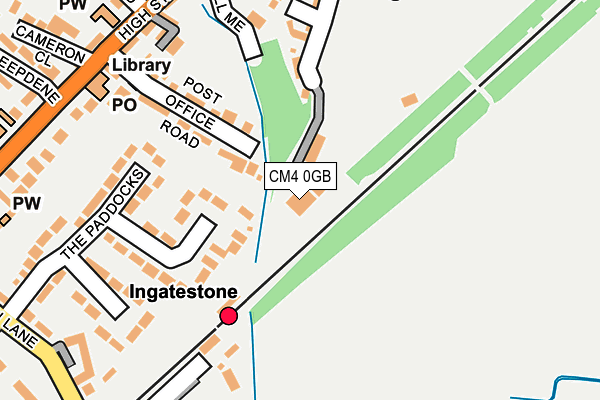
CM4 0GB is located in the Ingatestone, Fryerning and Mountnessing electoral ward, within the local authority district of Brentwood and the English Parliamentary constituency of Brentwood and Ongar. The Sub Integrated Care Board (ICB) Location is NHS Mid and South Essex ICB - 99E and the police force is Essex. This postcode has been in use since January 2009.


GetTheData
Source: OS OpenMap – Local (Ordnance Survey)
Source: OS VectorMap District (Ordnance Survey)
Licence: Open Government Licence (requires attribution)
| Easting | 565054 |
| Northing | 199272 |
| Latitude | 51.667981 |
| Longitude | 0.385337 |
GetTheData
Source: Open Postcode Geo
Licence: Open Government Licence
| Country | England |
| Postcode District | CM4 |
➜ See where CM4 is on a map ➜ Where is Ingatestone? | |
GetTheData
Source: Land Registry Price Paid Data
Licence: Open Government Licence
Elevation or altitude of CM4 0GB as distance above sea level:
| Metres | Feet | |
|---|---|---|
| Elevation | 60m | 197ft |
Elevation is measured from the approximate centre of the postcode, to the nearest point on an OS contour line from OS Terrain 50, which has contour spacing of ten vertical metres.
➜ How high above sea level am I? Find the elevation of your current position using your device's GPS.
GetTheData
Source: Open Postcode Elevation
Licence: Open Government Licence
| Ward | Ingatestone, Fryerning And Mountnessing |
| Constituency | Brentwood And Ongar |
GetTheData
Source: ONS Postcode Database
Licence: Open Government Licence
| Market Place (High Street) | Ingatestone | 270m |
| Alms Houses (High Street) | Ingatestone | 307m |
| Market Place (High Street) | Ingatestone | 312m |
| Alms Houses (High Street) | Ingatestone | 333m |
| Whadden Chase (Roman Road) | Ingatestone | 524m |
| Ingatestone Station | 0.1km |
| Billericay Station | 4.9km |
| Shenfield Station | 5.6km |
GetTheData
Source: NaPTAN
Licence: Open Government Licence
GetTheData
Source: ONS Postcode Database
Licence: Open Government Licence


➜ Get more ratings from the Food Standards Agency
GetTheData
Source: Food Standards Agency
Licence: FSA terms & conditions
| Last Collection | |||
|---|---|---|---|
| Location | Mon-Fri | Sat | Distance |
| Railway Station | 17:00 | 12:00 | 139m |
| Ingatestone Post Office | 17:45 | 12:30 | 233m |
| Co-op | 17:30 | 12:00 | 449m |
GetTheData
Source: Dracos
Licence: Creative Commons Attribution-ShareAlike
The below table lists the International Territorial Level (ITL) codes (formerly Nomenclature of Territorial Units for Statistics (NUTS) codes) and Local Administrative Units (LAU) codes for CM4 0GB:
| ITL 1 Code | Name |
|---|---|
| TLH | East |
| ITL 2 Code | Name |
| TLH3 | Essex |
| ITL 3 Code | Name |
| TLH36 | Heart of Essex |
| LAU 1 Code | Name |
| E07000068 | Brentwood |
GetTheData
Source: ONS Postcode Directory
Licence: Open Government Licence
The below table lists the Census Output Area (OA), Lower Layer Super Output Area (LSOA), and Middle Layer Super Output Area (MSOA) for CM4 0GB:
| Code | Name | |
|---|---|---|
| OA | E00109022 | |
| LSOA | E01021458 | Brentwood 002B |
| MSOA | E02004465 | Brentwood 002 |
GetTheData
Source: ONS Postcode Directory
Licence: Open Government Licence
| CM4 0GH | The Limes | 22m |
| CM4 9ES | Post Office Road | 141m |
| CM4 0BS | Summerfields | 157m |
| CM4 0BQ | The Paddocks | 170m |
| CM4 0BH | The Paddocks | 192m |
| CM4 0BB | Summerfields | 197m |
| CM4 0BD | Summerfields | 212m |
| CM4 0AR | High Street | 233m |
| CM4 0BG | The Limes | 235m |
| CM4 9EU | High Street | 249m |
GetTheData
Source: Open Postcode Geo; Land Registry Price Paid Data
Licence: Open Government Licence