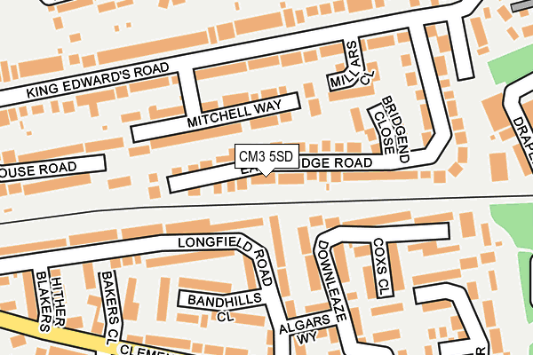
CM3 5SD lies on East Bridge Road in South Woodham Ferrers, Chelmsford. CM3 5SD is located in the South Woodham-Elmwood and Woodville electoral ward, within the local authority district of Chelmsford and the English Parliamentary constituency of Maldon. The Sub Integrated Care Board (ICB) Location is NHS Mid and South Essex ICB - 06Q and the police force is Essex. This postcode has been in use since January 1980.


GetTheData
Source: OS OpenMap – Local (Ordnance Survey)
Source: OS VectorMap District (Ordnance Survey)
Licence: Open Government Licence (requires attribution)
| Easting | 580946 |
| Northing | 197842 |
| Latitude | 51.650249 |
| Longitude | 0.614155 |
GetTheData
Source: Open Postcode Geo
Licence: Open Government Licence
| Street | East Bridge Road |
| Locality | South Woodham Ferrers |
| Town/City | Chelmsford |
| Country | England |
| Postcode District | CM3 |
➜ See where CM3 is on a map ➜ Where is South Woodham Ferrers? | |
GetTheData
Source: Land Registry Price Paid Data
Licence: Open Government Licence
Elevation or altitude of CM3 5SD as distance above sea level:
| Metres | Feet | |
|---|---|---|
| Elevation | 10m | 33ft |
Elevation is measured from the approximate centre of the postcode, to the nearest point on an OS contour line from OS Terrain 50, which has contour spacing of ten vertical metres.
➜ How high above sea level am I? Find the elevation of your current position using your device's GPS.
GetTheData
Source: Open Postcode Elevation
Licence: Open Government Licence
| Ward | South Woodham-elmwood And Woodville |
| Constituency | Maldon |
GetTheData
Source: ONS Postcode Database
Licence: Open Government Licence
| Mitchell Way (King Edward's Road) | South Woodham Ferrers | 147m |
| Railway Station (Hullbridge Road) | South Woodham Ferrers | 470m |
| Champions Manor Hall (Hullbridge Road) | South Woodham Ferrers | 472m |
| Railway Station (Hullbridge Road) | South Woodham Ferrers | 481m |
| Railway Station (Hullbridge Road) | South Woodham Ferrers | 496m |
| South Woodham Ferrers Station | 0.5km |
| Battlesbridge Station | 4.4km |
| North Fambridge Station | 4.7km |
GetTheData
Source: NaPTAN
Licence: Open Government Licence
| Percentage of properties with Next Generation Access | 100.0% |
| Percentage of properties with Superfast Broadband | 19.6% |
| Percentage of properties with Ultrafast Broadband | 0.0% |
| Percentage of properties with Full Fibre Broadband | 0.0% |
Superfast Broadband is between 30Mbps and 300Mbps
Ultrafast Broadband is > 300Mbps
| Median download speed | 19.1Mbps |
| Average download speed | 18.2Mbps |
| Maximum download speed | 62.57Mbps |
| Median upload speed | 1.4Mbps |
| Average upload speed | 2.5Mbps |
| Maximum upload speed | 13.12Mbps |
| Percentage of properties unable to receive 2Mbps | 0.0% |
| Percentage of properties unable to receive 5Mbps | 0.0% |
| Percentage of properties unable to receive 10Mbps | 0.0% |
| Percentage of properties unable to receive 30Mbps | 80.4% |
GetTheData
Source: Ofcom
Licence: Ofcom Terms of Use (requires attribution)
Estimated total energy consumption in CM3 5SD by fuel type, 2015.
| Consumption (kWh) | 573,084 |
|---|---|
| Meter count | 56 |
| Mean (kWh/meter) | 10,234 |
| Median (kWh/meter) | 10,028 |
| Consumption (kWh) | 222,372 |
|---|---|
| Meter count | 56 |
| Mean (kWh/meter) | 3,971 |
| Median (kWh/meter) | 3,327 |
GetTheData
Source: Postcode level gas estimates: 2015 (experimental)
Source: Postcode level electricity estimates: 2015 (experimental)
Licence: Open Government Licence
GetTheData
Source: ONS Postcode Database
Licence: Open Government Licence


➜ Get more ratings from the Food Standards Agency
GetTheData
Source: Food Standards Agency
Licence: FSA terms & conditions
| Last Collection | |||
|---|---|---|---|
| Location | Mon-Fri | Sat | Distance |
| Clement Green Lane | 17:00 | 10:15 | 344m |
| Hullbridge Road Post Office | 16:45 | 11:10 | 516m |
| Hullbridge Road | 17:00 | 08:30 | 520m |
GetTheData
Source: Dracos
Licence: Creative Commons Attribution-ShareAlike
The below table lists the International Territorial Level (ITL) codes (formerly Nomenclature of Territorial Units for Statistics (NUTS) codes) and Local Administrative Units (LAU) codes for CM3 5SD:
| ITL 1 Code | Name |
|---|---|
| TLH | East |
| ITL 2 Code | Name |
| TLH3 | Essex |
| ITL 3 Code | Name |
| TLH36 | Heart of Essex |
| LAU 1 Code | Name |
| E07000070 | Chelmsford |
GetTheData
Source: ONS Postcode Directory
Licence: Open Government Licence
The below table lists the Census Output Area (OA), Lower Layer Super Output Area (LSOA), and Middle Layer Super Output Area (MSOA) for CM3 5SD:
| Code | Name | |
|---|---|---|
| OA | E00109797 | |
| LSOA | E01021612 | Chelmsford 019B |
| MSOA | E02004503 | Chelmsford 019 |
GetTheData
Source: ONS Postcode Directory
Licence: Open Government Licence
| CM3 5PJ | Mitchell Way | 77m |
| CM3 5JL | Longfield Road | 123m |
| CM3 5PD | Bridgend Close | 128m |
| CM3 5JN | Longfield Road | 132m |
| CM3 5QF | Millars Close | 144m |
| CM3 5SN | Downleaze | 144m |
| CM3 5JW | Bandhills Close | 178m |
| CM3 5SL | Coxs Close | 181m |
| CM3 5SH | Algars Way | 185m |
| CM3 5PH | King Edwards Road | 187m |
GetTheData
Source: Open Postcode Geo; Land Registry Price Paid Data
Licence: Open Government Licence