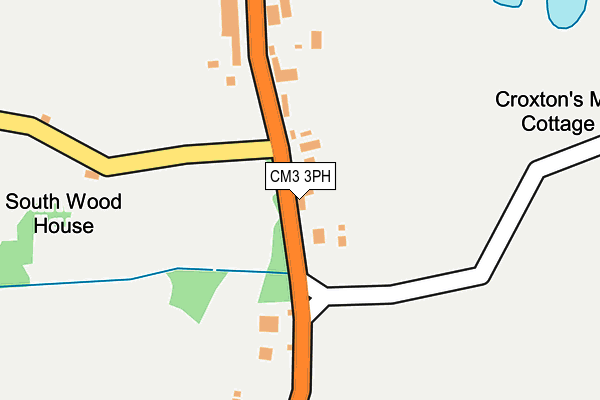
CM3 3PH lies on Blasford Hill in Little Waltham, Chelmsford. CM3 3PH is located in the Broomfield and The Walthams electoral ward, within the local authority district of Chelmsford and the English Parliamentary constituency of Saffron Walden. The Sub Integrated Care Board (ICB) Location is NHS Mid and South Essex ICB - 06Q and the police force is Essex. This postcode has been in use since January 1980.


GetTheData
Source: OS OpenMap – Local (Ordnance Survey)
Source: OS VectorMap District (Ordnance Survey)
Licence: Open Government Licence (requires attribution)
| Easting | 570774 |
| Northing | 211516 |
| Latitude | 51.776258 |
| Longitude | 0.473967 |
GetTheData
Source: Open Postcode Geo
Licence: Open Government Licence
| Street | Blasford Hill |
| Locality | Little Waltham |
| Town/City | Chelmsford |
| Country | England |
| Postcode District | CM3 |
➜ See where CM3 is on a map ➜ Where is Broomfield? | |
GetTheData
Source: Land Registry Price Paid Data
Licence: Open Government Licence
Elevation or altitude of CM3 3PH as distance above sea level:
| Metres | Feet | |
|---|---|---|
| Elevation | 40m | 131ft |
Elevation is measured from the approximate centre of the postcode, to the nearest point on an OS contour line from OS Terrain 50, which has contour spacing of ten vertical metres.
➜ How high above sea level am I? Find the elevation of your current position using your device's GPS.
GetTheData
Source: Open Postcode Elevation
Licence: Open Government Licence
| Ward | Broomfield And The Walthams |
| Constituency | Saffron Walden |
GetTheData
Source: ONS Postcode Database
Licence: Open Government Licence
ORCHARD COTTAGE, BLASFORD HILL, LITTLE WALTHAM, CHELMSFORD, CM3 3PH 2020 23 JUN £373,000 |
GetTheData
Source: HM Land Registry Price Paid Data
Licence: Contains HM Land Registry data © Crown copyright and database right 2025. This data is licensed under the Open Government Licence v3.0.
| Croxton's Mill (Blasford Hill) | Broomfield | 55m |
| Croxton's Mill (Blasford Hill) | Broomfield | 60m |
| Woodhouse Lane (Blansford Hill) | Broomfield | 235m |
| Woodhouse Lane (Blansford Hill) | Broomfield | 260m |
| Gernon Close (Hospital Approach) | Broomfield | 300m |
| Chelmsford Station | 4.5km |
GetTheData
Source: NaPTAN
Licence: Open Government Licence
| Percentage of properties with Next Generation Access | 100.0% |
| Percentage of properties with Superfast Broadband | 75.0% |
| Percentage of properties with Ultrafast Broadband | 0.0% |
| Percentage of properties with Full Fibre Broadband | 0.0% |
Superfast Broadband is between 30Mbps and 300Mbps
Ultrafast Broadband is > 300Mbps
| Percentage of properties unable to receive 2Mbps | 0.0% |
| Percentage of properties unable to receive 5Mbps | 0.0% |
| Percentage of properties unable to receive 10Mbps | 0.0% |
| Percentage of properties unable to receive 30Mbps | 25.0% |
GetTheData
Source: Ofcom
Licence: Ofcom Terms of Use (requires attribution)
GetTheData
Source: ONS Postcode Database
Licence: Open Government Licence


➜ Get more ratings from the Food Standards Agency
GetTheData
Source: Food Standards Agency
Licence: FSA terms & conditions
| Last Collection | |||
|---|---|---|---|
| Location | Mon-Fri | Sat | Distance |
| Church Avenue | 17:00 | 13:00 | 640m |
| Mill Lane | 17:10 | 13:00 | 1,150m |
| Goulton Road | 17:10 | 13:00 | 1,500m |
GetTheData
Source: Dracos
Licence: Creative Commons Attribution-ShareAlike
The below table lists the International Territorial Level (ITL) codes (formerly Nomenclature of Territorial Units for Statistics (NUTS) codes) and Local Administrative Units (LAU) codes for CM3 3PH:
| ITL 1 Code | Name |
|---|---|
| TLH | East |
| ITL 2 Code | Name |
| TLH3 | Essex |
| ITL 3 Code | Name |
| TLH36 | Heart of Essex |
| LAU 1 Code | Name |
| E07000070 | Chelmsford |
GetTheData
Source: ONS Postcode Directory
Licence: Open Government Licence
The below table lists the Census Output Area (OA), Lower Layer Super Output Area (LSOA), and Middle Layer Super Output Area (MSOA) for CM3 3PH:
| Code | Name | |
|---|---|---|
| OA | E00109442 | |
| LSOA | E01021541 | Chelmsford 001D |
| MSOA | E02004485 | Chelmsford 001 |
GetTheData
Source: ONS Postcode Directory
Licence: Open Government Licence
| CM3 3PQ | Blasford Hill | 33m |
| CM3 3PL | Blasford Hill | 122m |
| CM3 3PN | Blasford Hill | 157m |
| CM3 3PG | Blasford Hill | 247m |
| CM3 3PF | Blasford Hill | 247m |
| CM1 7HW | Gernon Close | 316m |
| CM3 3PW | 328m | |
| CM3 3PJ | Blasford Hill | 339m |
| CM1 7LE | Ayletts | 348m |
| CM1 7FD | The Windmills | 417m |
GetTheData
Source: Open Postcode Geo; Land Registry Price Paid Data
Licence: Open Government Licence